Journal of Geochemical Exploration ( IF 3.4 ) Pub Date : 2021-06-09 , DOI: 10.1016/j.gexplo.2021.106839 Mahyar Yousefi , Emmanuel John M. Carranza , Oliver P. Kreuzer , Vesa Nykänen , Jon M.A. Hronsky , Mark J. Mihalasky
|
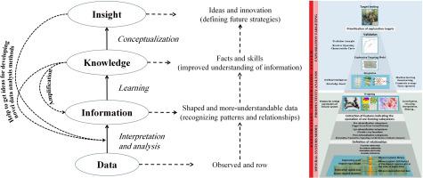
Mineral exploration targeting is a highly complex decision-making task. Two key risk factors, the quality of exploration data and robustness of the underlying conceptual targeting model, have a strong impact on the effectiveness of this decision-making. Geographic information systems (GIS) can be used not only for compiling, integrating, interrogating and interpreting diverse exploration data, but also for targeting by employing powerful mathematical algorithms, an approach that is commonly referred to as mineral potential modelling or mineral prospectivity mapping (MPM). Here, we pose and examine key aspects around the question of “how can we get better at mineral exploration targeting using GIS?” We do this by (1) reviewing the fundamental aspects of MPM, (2) identifying significant deficiencies of MPM, and (3) discussing possible solutions to alleviating or eliminating these deficiencies. In particular, we discuss how these deficiencies can be overcome by adopting an intelligence amplification system, such as the recently proposed exploration information system (EIS) for translating critical ore-forming processes into spatially predictive criteria (i.e., predictor maps and spatial proxies) and improving decision-making in mineral exploration targeting.
中文翻译:
应用于矿产勘探目标的远景建模数据分析方法:最新技术和展望
矿产勘探目标是一项高度复杂的决策任务。勘探数据的质量和基础概念目标模型的稳健性这两个关键风险因素对决策的有效性有很大影响。地理信息系统 (GIS) 不仅可以用于编译、整合、查询和解释各种勘探数据,还可以通过采用强大的数学算法进行定位,这种方法通常被称为矿产潜力建模或矿产远景图 (MPM) )。在这里,我们围绕“我们如何才能使用 GIS 更好地进行矿产勘探定位?”我们这样做是通过 (1) 审查 MPM 的基本方面,(2) 确定 MPM 的重大缺陷,以及 (3) 讨论减轻或消除这些缺陷的可能解决方案。特别是,我们讨论了如何通过采用情报放大系统来克服这些缺陷,例如最近提出的勘探信息系统(EIS),用于将关键的成矿过程转换为空间预测标准(即预测图和空间代理)和改进矿产勘探目标的决策。


 京公网安备 11010802027423号