Geoscience Frontiers ( IF 8.9 ) Pub Date : 2021-05-27 , DOI: 10.1016/j.gsf.2021.101230 Alireza Arabameri , Fatemeh Rezaie , Subodh Chandra Pal , Artemi Cerda , Asish Saha , Rabin Chakrabortty , Saro Lee
|
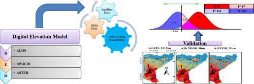
The geomorphic studies are extremely dependent on the quality and spatial resolution of digital elevation model (DEM) data. The unique terrain characteristics of a particular landscape are derived from DEM, which are responsible for initiation and development of ephemeral gullies. As the topographic features of an area significantly influences on the erosive power of the water flow, it is an important task the extraction of terrain features from DEM to properly research gully erosion. Alongside, topography is highly correlated with other geo-environmental factors i.e. geology, climate, soil types, vegetation density and floristic composition, runoff generation, which ultimately influences on gully occurrences. Therefore, terrain morphometric attributes derived from DEM data are used in spatial prediction of gully erosion susceptibility (GES) mapping. In this study, remote sensing-Geographic information system (GIS) techniques coupled with machine learning (ML) methods has been used for GES mapping in the parts of Semnan province, Iran. Current research focuses on the comparison of predicted GES result by using three types of DEM i.e. Advanced Land Observation satellite (ALOS), ALOS World 3D-30 m (AW3D30) and Advanced Space borne Thermal Emission and Reflection Radiometer (ASTER) in different resolutions. For further progress of our research work, here we have used thirteen suitable geo-environmental gully erosion conditioning factors (GECFs) based on the multi-collinearity analysis. ML methods of conditional inference forests (Cforest), Cubist model and Elastic net model have been chosen for modelling GES accordingly. Variable’s importance of GECFs was measured through sensitivity analysis and result show that elevation is the most important factor for occurrences of gullies in the three aforementioned ML methods (Cforest = 21.4, Cubist = 19.65 and Elastic net = 17.08), followed by lithology and slope. Validation of the model’s result was performed through area under curve (AUC) and other statistical indices. The validation result of AUC has shown that Cforest is the most appropriate model for predicting the GES assessment in three different DEMs (AUC value of Cforest in ALOS DEM is 0.994, AW3D30 DEM is 0.989 and ASTER DEM is 0.982) used in this study, followed by elastic net and cubist model. The output result of GES maps will be used by decision-makers for sustainable development of degraded land in this study area.
中文翻译:
管道坍塌和沟壑断头地貌建模:评估来自不同类型 DEM 的地形变量
地貌研究极其依赖于数字高程模型 (DEM) 数据的质量和空间分辨率。特定景观的独特地形特征源自 DEM,它负责短暂的沟壑的形成和发展。由于一个地区的地形特征对水流侵蚀力的影响很大,因此从DEM中提取地形特征以正确研究沟壑侵蚀是一项重要的任务。此外,地形与其他地质环境因素高度相关,例如地质、气候、土壤类型、植被密度和植物区系组成、径流生成,最终影响沟壑的发生。所以,源自 DEM 数据的地形形态测量属性用于沟壑侵蚀敏感性 (GES) 映射的空间预测。在这项研究中,遥感地理信息系统 (GIS) 技术与机器学习 (ML) 方法相结合,已被用于伊朗塞姆南省部分地区的 GES 制图。目前的研究重点是使用三种类型的DEM,即先进陆地观测卫星(ALOS)、ALOS World 3D-30 m(AW3D30)和先进星载热发射和反射辐射计(ASTER)在不同分辨率下的预测结果的比较。为了进一步推进我们的研究工作,我们在多重共线性分析的基础上使用了 13 个合适的地质环境沟蚀条件因子 (GECF)。条件推理森林(Cforest)的ML方法,相应地选择了立体派模型和弹性网模型来对 GES 进行建模。通过敏感性分析测量了GECFs的变量重要性,结果表明,在上述三种ML方法(Cforest = 21.4,Cubist = 19.65和Elastic net = 17.08)中,海拔是导致沟壑发生的最重要因素,其次是岩性和坡度。模型结果的验证通过曲线下面积 (AUC) 和其他统计指标进行。AUC的验证结果表明,Cforest是本研究使用的三种不同DEM(ALOS DEM中Cforest的AUC值为0.994,AW3D30 DEM为0.989,ASTER DEM为0.982)预测GES评估最合适的模型,随后通过弹性网和立体派模型。


 京公网安备 11010802027423号