当前位置:
X-MOL 学术
›
Earth Surf.Process. Land.
›
论文详情
Our official English website, www.x-mol.net, welcomes your feedback! (Note: you will need to create a separate account there.)
A comparison of hillslope drainage area estimation methods using high-resolution DEMs with implications for topographic studies of gullies
Earth Surface Processes and Landforms ( IF 3.3 ) Pub Date : 2021-05-24 , DOI: 10.1002/esp.5171 Simon J. Walker 1, 2 , Albert I. J. M. Dijk 1 , Scott N. Wilkinson 2 , Peter B. Hairsine 1
Earth Surface Processes and Landforms ( IF 3.3 ) Pub Date : 2021-05-24 , DOI: 10.1002/esp.5171 Simon J. Walker 1, 2 , Albert I. J. M. Dijk 1 , Scott N. Wilkinson 2 , Peter B. Hairsine 1
Affiliation
|
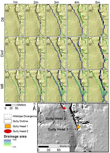
Topographic models provide a useful tool for understanding gully occurrence in the landscape but require reliable estimates of gully head drainage areas. Modern high-resolution topography data (collected using structure from motion photogrammetry or light detection and ranging) is increasingly used for topographic studies of gullies, but little work has been done to assess the variability of gully head drainage area estimates using different methods. This study evaluated alternative approaches to using high-resolution digital elevation models (DEMs) so that gully topographic models can be more readily applied to any area with suitably high-resolution data. Specifically, we investigated the impact of single- or multiple-direction flow routing algorithms, DEM hydrologic-enforcement procedures and spatial resolution on gully head drainage area estimation. We tested these methods on a 40 km2 site centred on Weany Creek, a low-relief semi-arid landscape draining towards the Great Barrier Reef, Australia. Using a subroutine to separate gully heads into those with divergent or convergent flow patterns upslope, we found that divergent flow conditions occurred at half of 484 studied gullies. Drainage areas estimated by different flow routing algorithms were more variable in these divergent cases than for convergent cases. This variation caused a significant difference between topographic threshold parameters (slope b and intercept k) derived from single- or multiple-direction flow routing algorithms, respectively. Different methods of hydrologic enforcement (filling or breaching) also affected threshold analysis, resulting in estimates of the exponent b being ~188% higher if the DEM was filled than if breached. The testing of the methods to date indicates that a finer resolution (≤2 m) DEM and a multiple-direction flow routing algorithm achieve the most realistic drainage area estimates in low-relief landscapes. For Weany Creek we estimated threshold parameters k = 0.033 and b = 0.189, indicating that it is highly susceptible to gully erosion.
中文翻译:

使用高分辨率 DEM 估算山坡流域面积的方法对沟壑地形研究的影响
地形模型为了解景观中的沟壑提供了有用的工具,但需要可靠地估计沟头流域面积。现代高分辨率地形数据(使用来自运动摄影测量或光探测和测距的结构收集)越来越多地用于沟渠的地形研究,但很少有工作使用不同的方法评估沟头流域面积估计的可变性。本研究评估了使用高分辨率数字高程模型 (DEM) 的替代方法,以便可以更轻松地将沟壑地形模型应用于具有适当高分辨率数据的任何区域。具体来说,我们研究了单向或多向流路由算法的影响,DEM 水文执行程序和沟头流域面积估计的空间分辨率。我们在 40 公里的路程上测试了这些方法2站点以 Weany Creek 为中心,这是一个流向澳大利亚大堡礁的低地势半干旱景观。使用子程序将沟水头分成具有发散或会聚流动模式的上坡沟,我们发现在 484 个研究的沟渠中,有一半发生了发散流条件。在这些发散情况下,由不同流量路由算法估计的排水面积比收敛情况下的变化更大。这种变化导致地形阈值参数(斜率b和截距k)分别源自单向或多向流路由算法之间的显着差异。不同的水文执法方法(填充或破坏)也会影响阈值分析,从而导致对指数的估计如果 DEM 被填充,则b比被破坏时高约 188%。迄今为止对方法的测试表明,更精细的分辨率 (≤2 m) DEM 和多方向流演算算法实现了低地貌景观中最真实的流域面积估计。对于 Weany Creek,我们估计阈值参数k = 0.033 和b = 0.189,表明它极易受到沟壑侵蚀。
更新日期:2021-05-24
中文翻译:
使用高分辨率 DEM 估算山坡流域面积的方法对沟壑地形研究的影响
地形模型为了解景观中的沟壑提供了有用的工具,但需要可靠地估计沟头流域面积。现代高分辨率地形数据(使用来自运动摄影测量或光探测和测距的结构收集)越来越多地用于沟渠的地形研究,但很少有工作使用不同的方法评估沟头流域面积估计的可变性。本研究评估了使用高分辨率数字高程模型 (DEM) 的替代方法,以便可以更轻松地将沟壑地形模型应用于具有适当高分辨率数据的任何区域。具体来说,我们研究了单向或多向流路由算法的影响,DEM 水文执行程序和沟头流域面积估计的空间分辨率。我们在 40 公里的路程上测试了这些方法2站点以 Weany Creek 为中心,这是一个流向澳大利亚大堡礁的低地势半干旱景观。使用子程序将沟水头分成具有发散或会聚流动模式的上坡沟,我们发现在 484 个研究的沟渠中,有一半发生了发散流条件。在这些发散情况下,由不同流量路由算法估计的排水面积比收敛情况下的变化更大。这种变化导致地形阈值参数(斜率b和截距k)分别源自单向或多向流路由算法之间的显着差异。不同的水文执法方法(填充或破坏)也会影响阈值分析,从而导致对指数的估计如果 DEM 被填充,则b比被破坏时高约 188%。迄今为止对方法的测试表明,更精细的分辨率 (≤2 m) DEM 和多方向流演算算法实现了低地貌景观中最真实的流域面积估计。对于 Weany Creek,我们估计阈值参数k = 0.033 和b = 0.189,表明它极易受到沟壑侵蚀。


 京公网安备 11010802027423号