Ecosystem Services ( IF 6.1 ) Pub Date : 2021-05-24 , DOI: 10.1016/j.ecoser.2021.101301 Kaegan M. Scully-Engelmeyer , Elise F. Granek , Max Nielsen-Pincus , Greg Brown
|
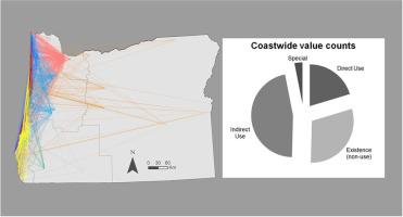
Consideration of social and cultural dimensions in coastal and marine planning has increased and ecosystem services provide important framing to investigate values and priorities associated with these systems. Research efforts in coastal communities offer insights on social dimensions of ocean and coastal management decisions, but questions remain about how demographics and geographic residence affect perceptions of marine resources and management. We conducted and analyzed a public participation geographic information system (PPGIS) mapping survey of Oregon residents to capture uses and perceived values of coastal and marine areas. We measured coastal values, explored regional differences in those values, and identified a suite of coastal and marine ecosystem services that Oregonians prioritize from the recently established marine reserve network. Examining respondent demographics, conservation values, and coastal geographic features, we discovered values varied by region in Oregon, with regions demonstrating distinct value orientations. Regional differences in value orientation highlight the importance of incorporating multiple interpretations of value into coastal resource communication strategies, and the consequence of coastal proximity on attitudes and values about coastal resources. Incorporating use (indirect and direct) and non-use (existence) values into a Total Economic Value framework revealed that participants prioritized indirect use (scenic, recreation) over direct use and existence values coastwide. Spatial variation of participant’s use and value locations demonstrates the utility of participatory mapping in marine spatial planning efforts, both in documenting spatially explicit non-market values of coastal areas and identifying potential areas of conflict among coastal stakeholder groups. Within Oregon’s marine reserve network, which was not delineated in the mapping exercise, value preferences diverged from coastwide averages, wherein existence values (biodiversity/wildlife, wilderness, etc.) were elevated above other categories.
中文翻译:
参与式GIS绘图突出了沿海资源和海洋保护区的间接利用和存在价值
沿海和海洋规划中对社会和文化方面的考虑有所增加,生态系统服务为调查与这些系统有关的价值和优先事项提供了重要的框架。沿海社区的研究工作提供了有关海洋和沿海管理决策的社会维度的见识,但有关人口统计学和地理住所如何影响海洋资源和管理观念的问题仍然存在。我们对俄勒冈州居民进行了公众参与地理信息系统(PPGIS)测绘调查,以分析沿海和海洋地区的用途和感知价值。我们测量了沿海价值,探索了这些价值之间的区域差异,并确定了一套俄勒冈州人从最近建立的海洋保护区网络中优先考虑的沿海和海洋生态系统服务。通过调查受访者的人口统计资料,保护价值和沿海地理特征,我们发现俄勒冈州各地区的价值有所不同,而各地区则表现出不同的价值取向。价值取向的区域差异突出了将价值的多种解释纳入沿海资源交流战略的重要性,以及沿海地区对沿海资源的态度和价值观的影响。将使用(间接和直接)和不使用(存在)的价值纳入总经济价值框架后,发现参与者将间接使用(风景,娱乐)的优先级高于整个海岸的直接使用和存在的价值。参与者使用和价值位置的空间变化证明了参与式制图在海洋空间规划工作中的实用性,既要记录沿海地区在空间上明确的非市场价值,又要确定沿海利益相关者群体之间潜在的冲突区域。在俄勒冈州的海洋保护区网络中(在制图活动中未进行描述),价值偏好与沿海地区的平均水平背离,沿海地区的平均存在价值(生物多样性/野生生物,荒野等)高于其他类别。


 京公网安备 11010802027423号