Soil and Tillage Research ( IF 6.1 ) Pub Date : 2021-05-21 , DOI: 10.1016/j.still.2021.105078 Lauri Ikkala , Anna-Kaisa Ronkanen , Olli Utriainen , Bjørn Kløve , Hannu Marttila
|
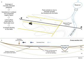
Peatlands worldwide are being threatened by intensive land use and drainage, which leads to soil subsidence. This has consequences for farming, especially on low-gradient cultivated peat-dominated lowlands with high flood risk. In this study, we combined historical soil elevation data and new lidar data to improve the estimation of subsidence and its consequences for lowland river systems. The results showed 202−349 mm subsidence within the last 24–51 years, with a mean rate of 5.15–9.47 mm y−1 for riparian peatland on the west coast of Finland. The subsidence rate was partly explained by the depth of the organic soil layer (R2 = 0.710, p > 0.05). The results also showed that increasing flooding of cultivated fields is mainly due to soil subsidence, not to increased flooding occurrence in river systems. The area flooded annually was found to increase by 101–194 % for the last 24–51 years, due to soil subsidence near rivers. Generalization of the results to catchment scale indicated an increase in the annual flood zone of 45 % in cultivated fields in one of two study catchments (Siikajoki river basin). These results demonstrate the value of using historical data to study soil subsidence and confirm that the risk of flooding increases in cultivated organic lowlands due to intensive drainage and subsidence. New management strategies, such as peatland rewetting, restoration, and paludiculture, should be considered in future land use plans to reduce subsidence and provide new income streams for farmers.
中文翻译:
泥炭地沉陷增加耕种的低地洪灾风险
全世界的泥炭地正受到密集的土地使用和排水的威胁,这导致土壤沉降。这对农业产生了影响,特别是在坡度低,以泥炭为主,低洪灾风险的低地上。在这项研究中,我们结合了历史土壤高程数据和新的激光雷达数据,以改善对沉降的估计及其对低地河流系统的影响。结果显示,过去24-51年内,地面沉降为202-349 mm ,芬兰西海岸的河岸泥炭地的平均速率为5.15-9.47 mm y -1。沉降速率部分由有机土壤层的深度(R 2= 0.710,p> 0.05)。结果还表明,耕地洪水泛滥的主要原因是土壤沉降,而不是河流系统中洪水泛滥的原因。在过去的24-51年中,由于河流附近的土壤沉降,每年的洪水泛滥面积增加了101-194%。结果对流域规模的概括表明,在两个研究流域之一(Siikajoki流域)中,耕地的年度洪水区增加了45%。这些结果证明了使用历史数据研究土壤沉降的价值,并证实了由于大量排水和沉降而造成的耕种有机低地洪水泛滥的风险增加了。新的管理策略,例如泥炭地的重新湿润,恢复和古生物学,


 京公网安备 11010802027423号