Marine Geology ( IF 2.6 ) Pub Date : 2021-05-14 , DOI: 10.1016/j.margeo.2021.106514 Eduardo G. Barboza , Sérgio R. Dillenburg , Renato P. Lopes , Maria Luiza C.C. Rosa , Felipe Caron , Vitor S. Abreu , Rogério P. Manzolli , José Carlos R. Nunes , Jair Weschenfelder , Luiz J. Tomazelli
|
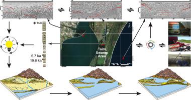
This paper describes the evolution of a sector of the southern coastal plain of the Pelotas Basin, southern Brazil, between the last Pleistocene sea-level lowstand and the Holocene highstand, based on geomorphology and high-resolution stratigraphy. A fluvial drainage system associated with an incised valley developed during the Last Glacial Maximum (LGM) was identified. Two high-resolution 2D and 2.5D geophysical profiles using Ground-Penetrating Radar (GPR) show a Pleistocene fluvial system's former path, starting close to its present mouth inside Mirim Lagoon crossing the coastal barriers and reaching the inner continental shelf, covering some 60 km across the coastal plain. During the LGM, with the sea-level at −120 to −130 m and the coastline positioned close to the shelf edge (distant 200 km from the present coastline), the fluvial system excavated a ~31.5-m deep channel. Two cores, 36 and 32 m long, show that the paleochannel was filled with sedimentary deposits after 19.4 ka BP, and the facies succession represents the transition from fluvial, to estuarine, to the coastal barrier, and finally to inner shelf depositional environments, generated by processes connected to LGM and the Postglacial Marine Transgression (PMT). The study region behaved as a sediment by-pass zone, connecting the adjacent coastal plain's inner portion with the inner continental shelf. The studied area presents an unusual record of the LGM at a coastal plain domain.
中文翻译:
巴西南部沿海平原和内陆陆架河床切口的地貌和地层演化
本文基于地貌学和高分辨率地层学,描述了巴西南部佩洛塔斯盆地南部沿海平原在最后一个更新世海平面低位和全新世高位之间的扇形演化。确定了与上一次冰川期最大(LGM)期间形成的切谷相关的河流排水系统。使用地面穿透雷达(GPR)的两个高分辨率2D和2.5D地球物理剖面显示了更新世河流系统的原路,从其现在的口开始在Mirim泻湖内穿越沿海屏障并到达内部大陆架,覆盖约60公里横跨沿海平原。在LGM期间,海平面为-120至-130 m,海岸线位于架子边缘附近(距当前海岸线200公里),河流系统开挖了约31.5米的深水沟。两个岩心分别为36和32 m,表明在19.4 ka BP后古河道充满了沉积物,相序代表了从河流向河口到沿海屏障的过渡,最后向内陆架沉积环境的转变。通过与LGM和冰河后海侵(PMT)相关的过程。研究区域表现为一个沉积物旁路区,将相邻的沿海平原的内部与大陆架相连接。所研究的地区在沿海平原地区呈现出LGM的异常记录。到河口,到沿海屏障,最后到内陆架沉积环境,这是由与LGM和冰河后海侵(PMT)相关的过程产生的。研究区域表现为一个沉积物旁路区,将相邻的沿海平原的内部与大陆架相连接。研究区域呈现了沿海平原地区LGM的异常记录。到河口,到沿海屏障,最后到内陆架沉积环境,这是由与LGM和冰河后海侵(PMT)相关的过程产生的。研究区域表现为一个沉积物旁路区,将相邻的沿海平原的内部与大陆架相连接。所研究的地区在沿海平原地区呈现出LGM的异常记录。


 京公网安备 11010802027423号