当前位置:
X-MOL 学术
›
Remote Sens. Ecol. Conserv.
›
论文详情
Our official English website, www.x-mol.net, welcomes your
feedback! (Note: you will need to create a separate account there.)
Capturing hedgerow structure and flowering abundance with UAV remote sensing
Remote Sensing in Ecology and Conservation ( IF 3.9 ) Pub Date : 2021-05-07 , DOI: 10.1002/rse2.208 Magdalena Smigaj 1, 2 , Rachel Gaulton 3
Remote Sensing in Ecology and Conservation ( IF 3.9 ) Pub Date : 2021-05-07 , DOI: 10.1002/rse2.208 Magdalena Smigaj 1, 2 , Rachel Gaulton 3
Affiliation
|
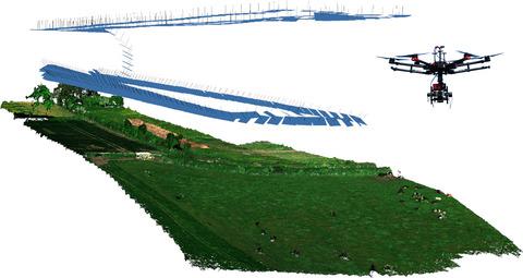
Hedgerows are an abundant and ecologically important feature of many rural areas. Their biodiversity value depends on composition, structure and availability of food resources, which can be significantly impacted by poor management. However, information about hedgerow condition is very limited due to field surveys being costly and labour-intensive. Unmanned aerial vehicles (UAVs) equipped with miniaturized cameras could prove a more cost-effective and time-efficient hedgerow surveying solution while preserving a high level of detail unattainable with airborne or satellite sensors. This study explored whether UAV remote sensing is a viable alternative for performing hedgerow condition surveys at local scale, focusing on hedgerow structure and flowering abundance. We acquired UAV Red, Green and Blue (RGB) and multispectral nadir and oblique imagery of structurally different hedgerows and used them to generate 3D point clouds and models with SfM workflow. Height thresholding allowed extraction of hedgerow extents, with root-mean-square error (RMSE) of height and width ranging from 0.11 to 0.23 m. RGB flower classification showed poor relationship with ground measurements (R2 = 0.31–0.42) due to confusion with woody material of hedgerows. Inclusion of a near-infrared channel in multispectral imagery significantly improved the relationship (R2 = 0.68–0.75, RMSE = 10%). Our study shows UAV remote sensing has high potential for performing detailed surveys of hedgerows, providing better characterization of structural variations and distribution of flowers than traditional ground surveys due to larger coverage. More comprehensive understanding of hedgerow, or other vegetated buffer strips, conditions offered by UAV surveys can enable better informed decisions on habitat management and biodiversity conservation in rural areas. Acquisitions over larger areas, potentially integrated with satellite remote sensing, can allow assessment of hedgerow connectivity over farm to landscape scales, contributing to better understanding of the hedgerow network and its role as a wildlife corridor.
中文翻译:

无人机遥感捕捉树篱结构和开花丰度
绿篱是许多农村地区丰富且具有重要生态意义的特征。它们的生物多样性价值取决于食物资源的组成、结构和可用性,管理不善会严重影响这些资源。然而,由于实地调查成本高且劳动密集,因此有关树篱状况的信息非常有限。配备微型摄像头的无人机 (UAV) 可以证明是一种更具成本效益和时间效率的树篱测量解决方案,同时保留了机载或卫星传感器无法获得的高水平细节。本研究探讨了无人机遥感是否是在局部范围内进行树篱条件调查的可行替代方案,重点是树篱结构和开花丰度。我们收购了 UAV Red,绿色和蓝色 (RGB) 以及结构不同的树篱的多光谱最低点和倾斜图像,并使用它们通过 SfM 工作流程生成 3D 点云和模型。高度阈值允许提取树篱范围,高度和宽度的均方根误差 (RMSE) 范围从 0.11 到 0.23 m。RGB 花卉分类与地面测量的相关性较差(R 2 = 0.31–0.42) 由于与树篱的木质材料混淆。在多光谱图像中加入近红外通道显着改善了这种关系 ( R 2 = 0.68–0.75,RMSE = 10%)。我们的研究表明,无人机遥感在对树篱进行详细调查方面具有很高的潜力,由于覆盖范围更大,与传统的地面调查相比,可以更好地表征结构变化和花卉分布。更全面地了解绿篱或其他植被缓冲带,无人机调查提供的条件可以使农村地区的栖息地管理和生物多样性保护做出更明智的决策。更大区域的采集,可能与卫星遥感相结合,可以评估农场到景观尺度的绿篱连通性,有助于更好地了解绿篱网络及其作为野生动物走廊的作用。
更新日期:2021-05-07
中文翻译:
无人机遥感捕捉树篱结构和开花丰度
绿篱是许多农村地区丰富且具有重要生态意义的特征。它们的生物多样性价值取决于食物资源的组成、结构和可用性,管理不善会严重影响这些资源。然而,由于实地调查成本高且劳动密集,因此有关树篱状况的信息非常有限。配备微型摄像头的无人机 (UAV) 可以证明是一种更具成本效益和时间效率的树篱测量解决方案,同时保留了机载或卫星传感器无法获得的高水平细节。本研究探讨了无人机遥感是否是在局部范围内进行树篱条件调查的可行替代方案,重点是树篱结构和开花丰度。我们收购了 UAV Red,绿色和蓝色 (RGB) 以及结构不同的树篱的多光谱最低点和倾斜图像,并使用它们通过 SfM 工作流程生成 3D 点云和模型。高度阈值允许提取树篱范围,高度和宽度的均方根误差 (RMSE) 范围从 0.11 到 0.23 m。RGB 花卉分类与地面测量的相关性较差(R 2 = 0.31–0.42) 由于与树篱的木质材料混淆。在多光谱图像中加入近红外通道显着改善了这种关系 ( R 2 = 0.68–0.75,RMSE = 10%)。我们的研究表明,无人机遥感在对树篱进行详细调查方面具有很高的潜力,由于覆盖范围更大,与传统的地面调查相比,可以更好地表征结构变化和花卉分布。更全面地了解绿篱或其他植被缓冲带,无人机调查提供的条件可以使农村地区的栖息地管理和生物多样性保护做出更明智的决策。更大区域的采集,可能与卫星遥感相结合,可以评估农场到景观尺度的绿篱连通性,有助于更好地了解绿篱网络及其作为野生动物走廊的作用。


 京公网安备 11010802027423号