当前位置:
X-MOL 学术
›
Glob. Chall.
›
论文详情
Our official English website, www.x-mol.net, welcomes your
feedback! (Note: you will need to create a separate account there.)
The Spatiotemporal Dynamics of Land Use Land Cover Change, and Its Impact on Soil Erosion in Tagaw Watershed, Blue Nile Basin, Ethiopia
Global Challenges ( IF 4.4 ) Pub Date : 2021-05-07 , DOI: 10.1002/gch2.202000109 Tadele Melese 1 , Abebe Senamaw 1 , Tatek Belay 2 , Getachew Bayable 1
Global Challenges ( IF 4.4 ) Pub Date : 2021-05-07 , DOI: 10.1002/gch2.202000109 Tadele Melese 1 , Abebe Senamaw 1 , Tatek Belay 2 , Getachew Bayable 1
Affiliation
|
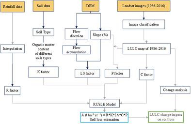
The Blue Nile basin is one of the hot-spots of soil erosion areas in Ethiopia. However, the impact of land use changes on soil erosion is poorly understood in the Tagaw watershed. Hence, the objective of the study is to assess the impact of land use changes on soil erosion in Tagaw watershed over the last 31 years. Rainfall, soil, satellite images and topographic data are acquired from field survey and secondary sources. A Revised Universal Soil Loss Equation (RUSLE) model is used to estimate soil erosion. The mean annual and total potential soil losses of the watershed are 19.3, 22.9, 26 and 0.06–503.56, 0.11–516.67, and 0.00–543.5 tons ha−1 yr−1 for 1995, 2006 and 2016 respectively. The highest soil loss is found for bare land. The RUSLE model further showed that the highest soil erosion occurred in 2016 whereas the lowest soil erosion occurred in 1995.
中文翻译:

埃塞俄比亚青尼罗河流域Tagaw流域土地利用土地覆盖变化时空动态及其对土壤侵蚀的影响
青尼罗河流域是埃塞俄比亚水土流失的热点地区之一。然而,人们对塔加流域土地利用变化对土壤侵蚀的影响知之甚少。因此,本研究的目的是评估过去 31 年土地利用变化对 Tagaw 流域土壤侵蚀的影响。降雨量、土壤、卫星图像和地形数据均通过实地调查和二手来源获得。修订后的通用土壤流失方程 (RUSLE) 模型用于估计土壤侵蚀。 1995年、2006年和2016年流域年平均和潜在土壤流失总量分别为19.3、22.9、26和0.06-503.56、0.11-516.67和0.00-543.5吨ha -1 yr -1 。裸地土壤流失量最大。 RUSLE模型进一步显示,土壤侵蚀最高发生在2016年,而土壤侵蚀最低发生在1995年。
更新日期:2021-07-12
中文翻译:
埃塞俄比亚青尼罗河流域Tagaw流域土地利用土地覆盖变化时空动态及其对土壤侵蚀的影响
青尼罗河流域是埃塞俄比亚水土流失的热点地区之一。然而,人们对塔加流域土地利用变化对土壤侵蚀的影响知之甚少。因此,本研究的目的是评估过去 31 年土地利用变化对 Tagaw 流域土壤侵蚀的影响。降雨量、土壤、卫星图像和地形数据均通过实地调查和二手来源获得。修订后的通用土壤流失方程 (RUSLE) 模型用于估计土壤侵蚀。 1995年、2006年和2016年流域年平均和潜在土壤流失总量分别为19.3、22.9、26和0.06-503.56、0.11-516.67和0.00-543.5吨ha -1 yr -1 。裸地土壤流失量最大。 RUSLE模型进一步显示,土壤侵蚀最高发生在2016年,而土壤侵蚀最低发生在1995年。


 京公网安备 11010802027423号