当前位置:
X-MOL 学术
›
Remote Sens. Ecol. Conserv.
›
论文详情
Our official English website, www.x-mol.net, welcomes your
feedback! (Note: you will need to create a separate account there.)
Improving the efficiency and accuracy of evaluating aridland riparian habitat restoration using unmanned aerial vehicles
Remote Sensing in Ecology and Conservation ( IF 3.9 ) Pub Date : 2021-05-05 , DOI: 10.1002/rse2.204 Martha Gómez‐Sapiens 1 , Karen J. Schlatter 2 , Ángela Meléndez 3 , Deus Hernández‐López 3 , Helen Salazar 3 , Eloise Kendy 4 , Karl W. Flessa 1
Remote Sensing in Ecology and Conservation ( IF 3.9 ) Pub Date : 2021-05-05 , DOI: 10.1002/rse2.204 Martha Gómez‐Sapiens 1 , Karen J. Schlatter 2 , Ángela Meléndez 3 , Deus Hernández‐López 3 , Helen Salazar 3 , Eloise Kendy 4 , Karl W. Flessa 1
Affiliation
|
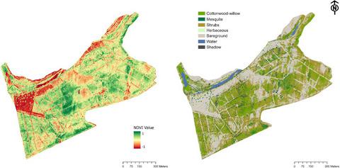
Unmanned Aerial Vehicles (UAVs) offer new opportunities for accurate, repeatable vegetation assessments, which are needed to adaptively manage restored habitat. We used UAVs, ground surveys, and satellite imagery to evaluate vegetation metrics for three riparian restoration sites along the Colorado River in Mexico and we compared the data accuracy and efficiency (cost and time requirements) between the three methods. We used an off-the-shelf UAV coupled with a multispectral sensor to determine Normalized Difference Vegetation Index (NDVI) and vegetation cover. We were unable to accurately classify vegetation by individual species, but by grouping riparian species of interest (cottonwood-willow, mesquite, shrubs), we achieved high overall model accuracies of 87–96% across sites (Kappa = 0.82–0.95). Producer’s and user’s accuracies were moderate to high for target vegetation classes (69–100%). UAV and ground-survey vegetation percent cover differed due to differences in methodologies (UAVs measure aerial cover; ground surveys measure foliar cover) and sources of error for each method. Correlations between UAV and ground survey vegetation cover were moderate (rs(90) = 0.24–0.58, p < 0.05). UAV NDVI (0.50–0.61) was significantly higher than Landsat NDVI (0.40–0.45) for all sites (p < 0.0001), likely due to presence of shadows with high NDVI values in UAV imagery. UAV NDVI, Landsat NDVI and UAV total vegetation cover were strongly correlated (rs(90) = 0.72–0.85, p < 0.05). UAV surveys were more labor- and cost- intensive than ground surveys in the first year, but were slightly less so in the second year. We conclude that UAVs can provide efficient, accurate assessments of riparian vegetation, which can be used in restoration site management. Due to UAV limitations to assess vegetation in a multi-layered canopy and inability to classify individual riparian species with similar spectral signals, we recommend a combined approach of UAV and ground surveys.
中文翻译:

提高无人机评估干旱河岸栖息地恢复的效率和准确性
无人驾驶飞行器 (UAV) 为准确、可重复的植被评估提供了新的机会,这是适应性管理恢复的栖息地所必需的。我们使用无人机、地面调查和卫星图像来评估墨西哥科罗拉多河沿岸三个河岸恢复点的植被指标,并比较了三种方法之间的数据准确性和效率(成本和时间要求)。我们使用现成的无人机和多光谱传感器来确定归一化差异植被指数 (NDVI) 和植被覆盖。我们无法按单个物种对植被进行准确分类,但通过对感兴趣的河岸物种(棉柳、豆科灌木、灌木)进行分组,我们实现了跨站点 87-96% 的高整体模型精度(Kappa = 0.82-0.95)。对于目标植被类别,生产者和用户的准确度为中到高(69-100%)。由于方法(无人机测量空中覆盖;地面调查测量叶面覆盖)和每种方法的误差来源不同,无人机和地面调查植被百分比覆盖率有所不同。无人机与地面调查植被覆盖之间的相关性适中(rs(90) = 0.24–0.58,p < 0.05)。无人机 NDVI (0.50–0.61) 显着高于所有站点的 Landsat NDVI (0.40–0.45) (p < 0.0001),这可能是由于无人机图像中存在具有高 NDVI 值的阴影。UAV NDVI、Landsat NDVI 和 UAV 总植被覆盖密切相关(rs(90) = 0.72–0.85, p < 0.05)。无人机调查在第一年比地面调查更耗费人力和成本,但在第二年略少。我们得出结论,无人机可以提供有效、准确的河岸植被评估,可用于恢复现场管理。由于无人机评估多层冠层植被的局限性以及无法对具有相似光谱信号的单个河岸物种进行分类,我们建议采用无人机和地面调查相结合的方法。
更新日期:2021-05-05
中文翻译:
提高无人机评估干旱河岸栖息地恢复的效率和准确性
无人驾驶飞行器 (UAV) 为准确、可重复的植被评估提供了新的机会,这是适应性管理恢复的栖息地所必需的。我们使用无人机、地面调查和卫星图像来评估墨西哥科罗拉多河沿岸三个河岸恢复点的植被指标,并比较了三种方法之间的数据准确性和效率(成本和时间要求)。我们使用现成的无人机和多光谱传感器来确定归一化差异植被指数 (NDVI) 和植被覆盖。我们无法按单个物种对植被进行准确分类,但通过对感兴趣的河岸物种(棉柳、豆科灌木、灌木)进行分组,我们实现了跨站点 87-96% 的高整体模型精度(Kappa = 0.82-0.95)。对于目标植被类别,生产者和用户的准确度为中到高(69-100%)。由于方法(无人机测量空中覆盖;地面调查测量叶面覆盖)和每种方法的误差来源不同,无人机和地面调查植被百分比覆盖率有所不同。无人机与地面调查植被覆盖之间的相关性适中(rs(90) = 0.24–0.58,p < 0.05)。无人机 NDVI (0.50–0.61) 显着高于所有站点的 Landsat NDVI (0.40–0.45) (p < 0.0001),这可能是由于无人机图像中存在具有高 NDVI 值的阴影。UAV NDVI、Landsat NDVI 和 UAV 总植被覆盖密切相关(rs(90) = 0.72–0.85, p < 0.05)。无人机调查在第一年比地面调查更耗费人力和成本,但在第二年略少。我们得出结论,无人机可以提供有效、准确的河岸植被评估,可用于恢复现场管理。由于无人机评估多层冠层植被的局限性以及无法对具有相似光谱信号的单个河岸物种进行分类,我们建议采用无人机和地面调查相结合的方法。


 京公网安备 11010802027423号