Geoscience Frontiers ( IF 8.5 ) Pub Date : 2021-05-05 , DOI: 10.1016/j.gsf.2021.101224 Mahfuzur Rahman , Chen Ningsheng , Golam Iftekhar Mahmud , Md Monirul Islam , Hamid Reza Pourghasemi , Hilal Ahmad , Jules Maurice Habumugisha , Rana Muhammad Ali Washakh , Mehtab Alam , Enlong Liu , Zheng Han , Huayong Ni , Tian Shufeng , Ashraf Dewan
|
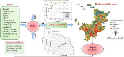
Bangladesh experiences frequent hydro-climatic disasters such as flooding. These disasters are believed to be associated with land use changes and climate variability. However, identifying the factors that lead to flooding is challenging. This study mapped flood susceptibility in the northeast region of Bangladesh using Bayesian regularization back propagation (BRBP) neural network, classification and regression trees (CART), a statistical model (STM) using the evidence belief function (EBF), and their ensemble models (EMs) for three time periods (2000, 2014, and 2017). The accuracy of machine learning algorithms (MLAs), STM, and EMs were assessed by considering the area under the curve—receiver operating characteristic (AUC-ROC). Evaluation of the accuracy levels of the aforementioned algorithms revealed that EM4 (BRBP-CART-EBF) outperformed (AUC > 90%) standalone and other ensemble models for the three time periods analyzed. Furthermore, this study investigated the relationships among land cover change (LCC), population growth (PG), road density (RD), and relative change of flooding (RCF) areas for the period between 2000 and 2017. The results showed that areas with very high susceptibility to flooding increased by 19.72% between 2000 and 2017, while the PG rate increased by 51.68% over the same period. The Pearson correlation coefficient for RCF and RD was calculated to be 0.496. These findings highlight the significant association between floods and causative factors. The study findings could be valuable to policymakers and resource managers as they can lead to improvements in flood management and reduction in flood damage and risks.
中文翻译:
洪水及其与土地覆盖变化、人口增长和道路密度的关系
孟加拉国经常遭受洪水等水文气候灾害。这些灾害被认为与土地利用变化和气候变化有关。然而,确定导致洪水的因素具有挑战性。本研究使用贝叶斯正则化反向传播 (BRBP) 神经网络、分类和回归树 (CART)、使用证据信念函数 (EBF) 的统计模型 (STM) 及其集成模型 ( EM)三个时间段(2000 年、2014 年和 2017 年)。机器学习算法 (MLA)、STM 和 EM 的准确性通过考虑曲线下面积 - 接收器操作特性 (AUC-ROC) 进行评估。对上述算法的准确性水平的评估表明,在分析的三个时间段内,EM4 (BRBP-CART-EBF) 的表现优于 (AUC > 90%) 独立模型和其他集成模型。此外,本研究调查了 2000 年至 2017 年期间土地覆盖变化 (LCC)、人口增长 (PG)、道路密度 (RD) 和洪水区相对变化 (RCF) 之间的关系。 2000 年至 2017 年间,极高的洪水敏感性增加了 19.72%,而同期 PG 率增加了 51.68%。RCF和RD的Pearson相关系数经计算为0.496。这些发现强调了洪水与致病因素之间的显着关联。


 京公网安备 11010802027423号