当前位置:
X-MOL 学术
›
J. Appl. Ecol.
›
论文详情
Our official English website, www.x-mol.net, welcomes your
feedback! (Note: you will need to create a separate account there.)
The impact of logging on vertical canopy structure across a gradient of tropical forest degradation intensity in Borneo
Journal of Applied Ecology ( IF 5.0 ) Pub Date : 2021-05-03 , DOI: 10.1111/1365-2664.13895 D.T. Milodowski 1, 2 , D.A. Coomes 3 , T. Swinfield 3, 4 , T. Jucker 3, 5 , T. Riutta 6, 7 , Y. Malhi 6 , M. Svátek 8 , J. Kvasnica 8 , D.F.R.P. Burslem 9 , R.M. Ewers 7 , Y.A. Teh 10 , M. Williams 1, 2
中文翻译:

伐木对婆罗洲热带森林退化强度梯度垂直冠层结构的影响
更新日期:2021-05-03
Journal of Applied Ecology ( IF 5.0 ) Pub Date : 2021-05-03 , DOI: 10.1111/1365-2664.13895 D.T. Milodowski 1, 2 , D.A. Coomes 3 , T. Swinfield 3, 4 , T. Jucker 3, 5 , T. Riutta 6, 7 , Y. Malhi 6 , M. Svátek 8 , J. Kvasnica 8 , D.F.R.P. Burslem 9 , R.M. Ewers 7 , Y.A. Teh 10 , M. Williams 1, 2
Affiliation
|
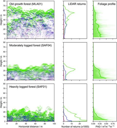
- Forest degradation through logging is pervasive throughout the world's tropical forests, leading to changes in the three-dimensional canopy structure that have profound consequences for wildlife, microclimate and ecosystem functioning. Quantifying these structural changes is fundamental to understanding the impact of degradation, but is challenging in dense, structurally complex forest canopies.
- We exploited discrete-return airborne LiDAR surveys across a gradient of logging intensity in Sabah, Malaysian Borneo, and assessed how selective logging had affected canopy structure (Plant Area Index, PAI, and its vertical distribution within the canopy).
- LiDAR products compared well to independent, analogue models of canopy structure produced from detailed ground-based inventories undertaken in forest plots, demonstrating the potential for airborne LiDAR to quantify the structural impacts of forest degradation at landscape scale, even in some of the world's tallest and most structurally complex tropical forests.
- Plant Area Index estimates across the plot network exhibited a strong linear relationship with stem basal area (R2 = 0.95). After at least 11–14 years of recovery, PAI was ~28% lower in moderately logged plots and ~52% lower in heavily logged plots than that in old-growth forest plots. These reductions in PAI were associated with near-complete lack of trees >30-m tall, which had not been fully compensated for by increasing plant area lower in the canopy. This structural change drives a marked reduction in the diversity of canopy environments, with the deep, dark understorey conditions characteristic of old-growth forests far less prevalent in logged sites. Full canopy recovery is likely to take decades.
- Synthesis and applications. Effective management and restoration of tropical forests requires detailed monitoring of the forest and its environment. We demonstrate that airborne LiDAR can effectively map the canopy architecture of the complex tropical forests of Borneo, capturing the three-dimensional impact of degradation on canopy structure at landscape scales, therefore facilitating efforts to restore and conserve these ecosystems.
中文翻译:
伐木对婆罗洲热带森林退化强度梯度垂直冠层结构的影响
- 伐木导致的森林退化在世界热带森林中普遍存在,导致三维冠层结构发生变化,对野生动物、小气候和生态系统功能产生深远影响。量化这些结构变化是了解退化影响的基础,但在密集、结构复杂的森林冠层中具有挑战性。
- 我们在马来西亚婆罗洲沙巴的采伐强度梯度上利用了离散返回机载 LiDAR 调查,并评估了选择性采伐如何影响冠层结构(植物面积指数、PAI 及其在冠层内的垂直分布)。
- LiDAR 产品与根据在森林地块进行的详细地面清单生成的独立的、模拟的冠层结构模型进行了很好的比较,证明了机载 LiDAR 有潜力在景观尺度上量化森林退化的结构影响,即使在世界上一些最高和结构最复杂的热带森林。
- 整个小区网络的植物面积指数估计值与茎基面积 ( R 2 = 0.95)表现出很强的线性关系。经过至少 11-14 年的恢复,中度采伐地块的 PAI 比原始森林地块的 PAI 低约 28%,重度采伐地块的 PAI 降低约 52%。PAI 的这些减少与几乎完全缺乏> 30 米高的树木有关,这并没有通过增加树冠下部的植物面积来完全补偿。这种结构变化导致冠层环境多样性显着减少,原始森林特有的深而黑暗的林下条件在采伐地点远不那么普遍。完全恢复树冠可能需要几十年的时间。
- 合成与应用。热带森林的有效管理和恢复需要对森林及其环境进行详细监测。我们证明机载 LiDAR 可以有效地绘制婆罗洲复杂热带森林的冠层结构图,捕捉退化对景观尺度冠层结构的三维影响,从而促进恢复和保护这些生态系统的努力。


 京公网安备 11010802027423号