当前位置:
X-MOL 学术
›
Geogr. Res.
›
论文详情
Our official English website, www.x-mol.net, welcomes your
feedback! (Note: you will need to create a separate account there.)
New conceptual framework for flood risk assessment in Sheffield, UK
Geographical Research ( IF 2.9 ) Pub Date : 2021-05-03 , DOI: 10.1111/1745-5871.12478 I‐Hui Chen 1
Geographical Research ( IF 2.9 ) Pub Date : 2021-05-03 , DOI: 10.1111/1745-5871.12478 I‐Hui Chen 1
Affiliation
|
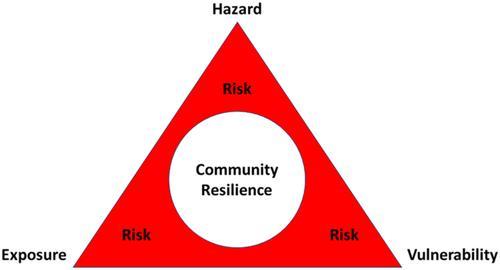
This study explores a new framework of flood risk assessment that considers four components, namely hazard, exposure, vulnerability, and community resilience. The key variables and coefficients were selected using principal component analysis and geographically weighted regression (GWR) in a geographic information system (GIS). GWR was applied to present a spatial relation between flood risks and regeneration areas for dependent and independent variables in the four components. Then the new conceptual framework was overlaid as a flood risk map using risk indicators of the four components. The first three components were included in the GIS framework to map flood risk indices, whereas the community resilience component was subtracted from the total indices. Finally, the total number of indices of the flood risk map were divided into nine levels, from 0 to 8. Overall, the study shows the utility of the flood risk map, which is based on the spatial coincidence of mapping of the four components in a case study of Sheffield in the United Kingdom. Areas with an index value of 8 on the flood risk map had the highest flood risks, which points to where there is a need for regeneration to improve flood defences and resilience.
中文翻译:

英国谢菲尔德洪水风险评估的新概念框架
本研究探索了一个新的洪水风险评估框架,该框架考虑了四个组成部分,即灾害、暴露、脆弱性和社区恢复力。在地理信息系统 (GIS) 中使用主成分分析和地理加权回归 (GWR) 选择关键变量和系数。应用 GWR 来呈现洪水风险和再生区域之间的空间关系,用于四个分量中的因变量和自变量。然后使用四个组成部分的风险指标将新的概念框架叠加为洪水风险图。前三个组成部分包含在 GIS 框架中以绘制洪水风险指数,而社区复原力组成部分从总指数中减去。最后,将洪水风险图的指标总数分为九个级别,从 0 到 8。总体而言,该研究显示了洪水风险图的效用,该图基于英国谢菲尔德案例研究中四个分量映射的空间重合。洪水风险地图上指数值为 8 的区域洪水风险最高,这表明需要重建以提高洪水防御和恢复能力的区域。
更新日期:2021-05-03
中文翻译:
英国谢菲尔德洪水风险评估的新概念框架
本研究探索了一个新的洪水风险评估框架,该框架考虑了四个组成部分,即灾害、暴露、脆弱性和社区恢复力。在地理信息系统 (GIS) 中使用主成分分析和地理加权回归 (GWR) 选择关键变量和系数。应用 GWR 来呈现洪水风险和再生区域之间的空间关系,用于四个分量中的因变量和自变量。然后使用四个组成部分的风险指标将新的概念框架叠加为洪水风险图。前三个组成部分包含在 GIS 框架中以绘制洪水风险指数,而社区复原力组成部分从总指数中减去。最后,将洪水风险图的指标总数分为九个级别,从 0 到 8。总体而言,该研究显示了洪水风险图的效用,该图基于英国谢菲尔德案例研究中四个分量映射的空间重合。洪水风险地图上指数值为 8 的区域洪水风险最高,这表明需要重建以提高洪水防御和恢复能力的区域。


 京公网安备 11010802027423号