Remote Sensing of Environment ( IF 11.1 ) Pub Date : 2021-05-03 , DOI: 10.1016/j.rse.2021.112474 J.J. Carrera-Hernández
|
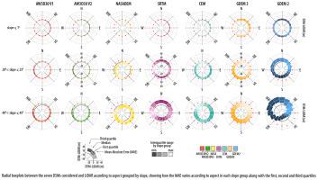
This work assesses the vertical accuracy of eight Digital Surface Models (DSMs) currently available for Mexico (LiDAR, ALOS AW3D30 V2 and V3, ASTER GDEM V2 and V3, SRTM, NASADEM and Mexico's Continuous Elevation Model (CEM)). The AW3D30, ASTER GDEM, SRTM and NASADEM DSMs cover nearly the entire globe and can be downloaded at no cost, while the LiDAR and CEM DSMs are distributed by Mexico's Institute of Geography and Statistics (INEGI). The accuracy of these DSMs is assessed by considering: 1) benchmarks as reference data at the national level, and 2) LiDAR DSM as reference data on six different zones with variability in slope, vegetation cover and elevation. Using geodetic benchmarks as reference elevation on those areas covered by LiDAR (ALiDAR=370,200 km2, nbench=24,175), it was found that LiDAR has the best vertical accuracy of all DSMs considered (MAELiDAR = 1.96), which is why it was used as reference elevation to develop seven DEMs of Difference (DoDs) with the remainder DSMs. Using ncells = 350 × 106 for the aforementioned comparisons, it was found that the vertical accuracy of AW3D30 V2 and V3 is similar (MAE=2.5 m), followed by NASADEM, SRTM, CEM, ASTER GDEM3 and ASTER GDEM 2, with MAE values of 3.1, 3.8, 4.6, 6.0 and 7.2 m respectively. The previously mentioned values vary according to slope and slope orientation (i.e. aspect): for flat areas (slope≤5∘), the NASADEM exhibits the lowest MAE (with MAE values of 1.6 for slope≤1∘ and MAE = 2.0 m when 1∘<slope≤5∘), whereas MAEAW3D30V3=1.9 and 2.2 m for the previously mentioned slopes. With the use of radial boxplots developed on slope groups of 5∘, it was found that both MAE and bias are increasingly affected by aspect as slope increases on all the DSMs. In the case of both AW3D30 DSMs, on flat terrain a difference of only 0.1 m in bias (i.e. median of differences with respect to LiDAR) is found between SE and NW slopes; however, this difference increases according to slope: 0.6 m for 5∘<slope≤10∘, 1.2 m for 10∘<slope≤15∘, and 1.9 m for 15∘<slope≤20∘. Through the analyses undertaken, it is shown that slope—and not vegetation cover—is the factor that has the largest impact on the error of DSMs, and that the effect of aspect on error increases as terrain steepens. This work shows that all DSMs present errors and that an adequate accuracy assessment of DSMs needs to consider the spatial distribution of GCPs, Difference of DSMs (DoDs) and derivatives of DSMs (i.e., slope and aspect) as the use of DoDs provide information on DSM errors (i.e. interpolation artefacts) that can not be assessed through the use of geodetic benchmarks and because DSM errors depend on both slope and aspect.
中文翻译:
并非所有DEM都是平等的:在墨西哥对六个全球可用的30 m分辨率DEM进行了评估,其中包括大地测量基准和LiDAR
这项工作评估了当前可用于墨西哥的八个数字表面模型(DSM)的垂直精度(LiDAR,ALOS AW3D30 V2和V3,ASTER GDEM V2和V3,SRTM,NASADEM和墨西哥的连续高程模型(CEM))。AW3D30,ASTER GDEM,SRTM和NASADEM DSM几乎覆盖全球,可以免费下载,而LiDAR和CEM DSM由墨西哥地理与统计研究所(INEGI)分发。通过考虑以下因素来评估这些DSM的准确性:1)基准作为国家一级的参考数据,以及2)LiDAR DSM作为六个不同区域的参考数据,这些区域的坡度,植被覆盖度和高程都有变化。使用大地基准作为LiDAR覆盖区域的参考高程(A LiDAR = 370,200 km 2,n基准= 24,175),发现LiDAR在所有考虑的DSM中具有最高的垂直精度(MAE LiDAR = 1.96),这就是为什么它被用作与其他DSM一起开发七个差异DEM(DoD)的参考标高的原因。使用n单元 = 350×10 6进行上述比较,发现AW3D30 V2和V3的垂直精度相似(MAE = 2.5 m),其次是NASADEM,SRTM,CEM,ASTER GDEM3和ASTER GDEM 2, MAE值分别为3.1、3.8、4.6、6.0和7.2 m。前面提到的值根据斜率和斜率取向(即方面)而变化:对于平坦区域(slope≤5 ∘)时,表现出NASADEM 1.6最低MAE(具有MAE值slope≤1 ∘和MAE =2.0米当1 ∘ <slope≤5 ∘),而MAE AW3D30V3 = 1.9和2.2米为前面提到的斜坡。与使用上的5组斜率开发径向盒状图的∘,人们发现,MAE和偏压两者都日益受到作为所有的DSM的斜率增加方面。在两个AW3D30 DSM的情况下,在平坦地形上SE和NW斜率之间的偏差仅为0.1 m(即,相对于LiDAR的差异的中值);然而,这种差异根据斜率增加:0.6 m表示5 ∘ <slope≤10 ∘,1.2米10 ∘ <slope≤15 ∘,和1.9米15 ∘ <slope≤20 ∘。通过进行的分析表明,坡度而不是植被覆盖度是对DSMs误差影响最大的因素,并且当地形变陡时,坡向对误差的影响会增加。这项工作表明,所有DSM都存在错误,并且对DSM进行足够的准确性评估时,需要考虑GCP的空间分布,DSM的差异(DoDs)和DSM的导数(即斜率和纵横比),因为使用DoD可以提供有关以下方面的信息: DSM错误(即插值伪像)无法通过使用大地测量基准进行评估,并且因为DSM错误取决于坡度和坡度。


 京公网安备 11010802027423号