当前位置:
X-MOL 学术
›
Ecol. Evol.
›
论文详情
Our official English website, www.x-mol.net, welcomes your feedback! (Note: you will need to create a separate account there.)
Spatial–temporal variations in deforestation hotspots in Sumatra and Kalimantan from 2001–2018
Ecology and Evolution ( IF 2.6 ) Pub Date : 2021-05-02 , DOI: 10.1002/ece3.7562 Minerva Singh 1 , Siheng Yan 1
Ecology and Evolution ( IF 2.6 ) Pub Date : 2021-05-02 , DOI: 10.1002/ece3.7562 Minerva Singh 1 , Siheng Yan 1
Affiliation
|
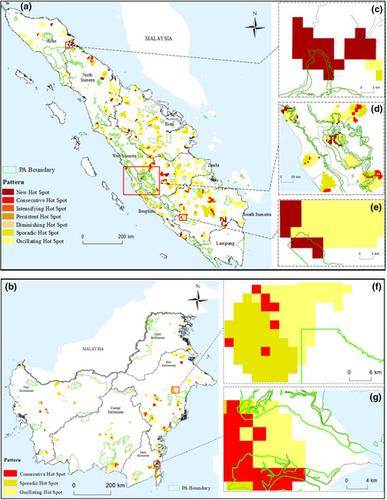
Tropical deforestation varies temporally and spatially which can inhibit the ability of existing protected areas to stem forest loss. Identifying the spatial–temporal distribution of deforestation and its concentration can help decision makers decide conservation priorities and leverage limited resources. This study assessed how topographic and anthropogenic variables affect deforestation patterns within and outside protected areas on the islands of Sumatra and Kalimantan in Indonesia. Emerging hotspot analysis (EHA) was used to evaluate spatial and temporal trends of forest loss on the Hansen annual forest loss data for these islands from 2001–2018. For the two islands, most hotspots were detected outside protected areas; those within protected areas were mainly concentrated at boundaries, where lower elevation/slope and high human pressure could be observed. New hotspots were identified within the three PAs in Sumatra, while three kinds of hotspots (consecutive, oscillating, and sporadic) were found in the two PAs of Kalimantan (Kutai and Teluk Kelumpang). Areas with high human pressure (average human footprint higher than 12) were covered by a high density of hotspots. The results identify specific areas where forest loss has emerged recently, which could indicate a conservation priority. It is suggested that new protected areas be established in locations showing intensifying and persistent hotspots—those where deforestation has occurred for ≥16 of 18 years of the study period.
中文翻译:

2001-2018 年苏门答腊和加里曼丹森林砍伐热点的时空变化
热带森林砍伐在时间和空间上各不相同,这会抑制现有保护区阻止森林流失的能力。确定森林砍伐的时空分布及其集中度可以帮助决策者决定保护优先事项并利用有限的资源。本研究评估了地形和人为变量如何影响印度尼西亚苏门答腊岛和加里曼丹岛保护区内外的森林砍伐模式。新兴热点分析 (EHA) 用于评估这些岛屿 2001-2018 年汉森年度森林损失数据中森林损失的时空趋势。对于这两个岛屿,大多数热点都在保护区之外;保护区内的主要集中在边界,在那里可以观察到较低的海拔/坡度和较高的人体压力。在苏门答腊的三个保护区内发现了新的热点,而在加里曼丹的两个保护区(古泰和 Teluk Kelumpang)发现了三种热点(连续、振荡和零星)。人类压力大的区域(平均人类足迹高于 12)被高密度热点覆盖。结果确定了最近出现森林损失的特定区域,这可能表明保护优先事项。建议在热点持续加剧的地区建立新的保护区——在研究期间的 18 年中,森林砍伐的时间≥16 年。和零星)在加里曼丹的两个保护区(Kutai 和 Teluk Kelumpang)被发现。人类压力大的区域(平均人类足迹高于 12)被高密度热点覆盖。结果确定了最近出现森林损失的特定区域,这可能表明保护优先事项。建议在热点持续加剧的地区建立新的保护区——在研究期间的 18 年中,森林砍伐的时间≥16 年。和零星)在加里曼丹的两个保护区(Kutai 和 Teluk Kelumpang)被发现。人类压力大的区域(平均人类足迹高于 12)被高密度热点覆盖。结果确定了最近出现森林损失的特定区域,这可能表明保护优先事项。建议在热点持续加剧的地区建立新的保护区——在研究期间的 18 年中,森林砍伐的时间≥16 年。
更新日期:2021-06-22
中文翻译:
2001-2018 年苏门答腊和加里曼丹森林砍伐热点的时空变化
热带森林砍伐在时间和空间上各不相同,这会抑制现有保护区阻止森林流失的能力。确定森林砍伐的时空分布及其集中度可以帮助决策者决定保护优先事项并利用有限的资源。本研究评估了地形和人为变量如何影响印度尼西亚苏门答腊岛和加里曼丹岛保护区内外的森林砍伐模式。新兴热点分析 (EHA) 用于评估这些岛屿 2001-2018 年汉森年度森林损失数据中森林损失的时空趋势。对于这两个岛屿,大多数热点都在保护区之外;保护区内的主要集中在边界,在那里可以观察到较低的海拔/坡度和较高的人体压力。在苏门答腊的三个保护区内发现了新的热点,而在加里曼丹的两个保护区(古泰和 Teluk Kelumpang)发现了三种热点(连续、振荡和零星)。人类压力大的区域(平均人类足迹高于 12)被高密度热点覆盖。结果确定了最近出现森林损失的特定区域,这可能表明保护优先事项。建议在热点持续加剧的地区建立新的保护区——在研究期间的 18 年中,森林砍伐的时间≥16 年。和零星)在加里曼丹的两个保护区(Kutai 和 Teluk Kelumpang)被发现。人类压力大的区域(平均人类足迹高于 12)被高密度热点覆盖。结果确定了最近出现森林损失的特定区域,这可能表明保护优先事项。建议在热点持续加剧的地区建立新的保护区——在研究期间的 18 年中,森林砍伐的时间≥16 年。和零星)在加里曼丹的两个保护区(Kutai 和 Teluk Kelumpang)被发现。人类压力大的区域(平均人类足迹高于 12)被高密度热点覆盖。结果确定了最近出现森林损失的特定区域,这可能表明保护优先事项。建议在热点持续加剧的地区建立新的保护区——在研究期间的 18 年中,森林砍伐的时间≥16 年。


 京公网安备 11010802027423号