当前位置:
X-MOL 学术
›
Hydrol. Process.
›
论文详情
Our official English website, www.x-mol.net, welcomes your
feedback! (Note: you will need to create a separate account there.)
The Kwakshua Watersheds Observatory, central coast of British Columbia, Canada
Hydrological Processes ( IF 2.8 ) Pub Date : 2021-04-30 , DOI: 10.1002/hyp.14198 Ian J. W. Giesbrecht 1, 2 , William C. Floyd 3, 4 , Suzanne E. Tank 1, 5 , Ken P. Lertzman 1, 2 , Brian P. V. Hunt 1, 6 , Maartje C. Korver 1, 7 , Allison A. Oliver 1, 5, 8 , Ray Brunsting 1 , Paul Sanborn 1, 9 , Santiago G. Gonzalez Arriola 1 , Gordon W. Frazer 1, 10 , Kyra A. St. Pierre 1, 6 , Shawn Hateley 1 , James McPhail 1, 11 , Colby Owen 1, 11 , Stewart Butler 3 , Bryn Fedje 1 , Emma Myers 1 , Lucy Quayle 1 , Emily Haughton 1 , Isabelle Desmarais 1 , Rob White 1 , David J. Levy‐Booth 1, 12 , Colleen T. E. Kellogg 1 , Jennifer M. Jackson 1 , William W. Mohn 12 , Steven J. Hallam 12 , Justin Del Bel Belluz 1
Hydrological Processes ( IF 2.8 ) Pub Date : 2021-04-30 , DOI: 10.1002/hyp.14198 Ian J. W. Giesbrecht 1, 2 , William C. Floyd 3, 4 , Suzanne E. Tank 1, 5 , Ken P. Lertzman 1, 2 , Brian P. V. Hunt 1, 6 , Maartje C. Korver 1, 7 , Allison A. Oliver 1, 5, 8 , Ray Brunsting 1 , Paul Sanborn 1, 9 , Santiago G. Gonzalez Arriola 1 , Gordon W. Frazer 1, 10 , Kyra A. St. Pierre 1, 6 , Shawn Hateley 1 , James McPhail 1, 11 , Colby Owen 1, 11 , Stewart Butler 3 , Bryn Fedje 1 , Emma Myers 1 , Lucy Quayle 1 , Emily Haughton 1 , Isabelle Desmarais 1 , Rob White 1 , David J. Levy‐Booth 1, 12 , Colleen T. E. Kellogg 1 , Jennifer M. Jackson 1 , William W. Mohn 12 , Steven J. Hallam 12 , Justin Del Bel Belluz 1
Affiliation
|
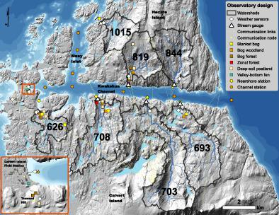
The Kwakshua Watersheds Observatory (KWO) is an integrative watersheds observatory on the coastal margin of a rain-dominated bog-forest landscape in British Columbia (BC), Canada. Established in 2013, the goal of the KWO is to understand and model the flux of terrestrial materials from land to sea – the origins, pathways, processes and ecosystem consequences – in the context of long-term environmental change. The KWO consists of seven gauged watersheds and a network of observation sites spanning from land to sea and along drainage gradients within catchments. Time-series datasets include year-round measurements of weather, soil hydrology, streamflow, aquatic biogeochemistry, microbial ecology and nearshore oceanographic conditions. Sensor measurements are recorded every 5 min and water samples are collected approximately monthly. Additional observations are made during high-flow conditions. We used remote sensing to map watershed terrain, drainage networks, soils and terrestrial ecosystems. The watersheds range in size from 3.2 to 12.8 km2, with varying catchment characteristics that influence hydrological and biogeochemical responses. Despite local variation, the overall study area is a global hotspot for yields of dissolved organic carbon, dissolved organic nitrogen and dissolved iron at the coastal margin. This observatory helps fill an important gap in the global network of observatories, in terms of spatial location (central coast of BC), climate (temperate oceanic), hydrology (very high runoff, pluvial regime), geology (igneous intrusive, glacially scoured), vegetation (bog rainforest) and soils (large stores of organic carbon).
中文翻译:

加拿大不列颠哥伦比亚省中部海岸的夸克舒亚流域天文台
夸克舒亚流域天文台 (KWO) 是一个综合流域天文台,位于加拿大不列颠哥伦比亚省 (BC) 以雨水为主的沼泽森林景观的沿海边缘。KWO 成立于 2013 年,其目标是在长期环境变化的背景下了解和模拟从陆地到海洋的陆地物质通量——起源、途径、过程和生态系统后果。KWO 由七个测量的流域和一个从陆地到海洋以及沿流域内的排水梯度的观测点网络组成。时间序列数据集包括对天气、土壤水文、河流流量、水生生物地球化学、微生物生态学和近岸海洋条件的全年测量。每 5 分钟记录一次传感器测量值,大约每月收集一次水样。在高流量条件下进行了额外的观察。我们使用遥感来绘制流域地形、排水网络、土壤和陆地生态系统的地图。流域大小从 3.2 到 12.8 公里不等2,具有影响水文和生物地球化学响应的不同流域特征。尽管存在局部差异,但整个研究区域是沿海边缘溶解有机碳、溶解有机氮和溶解铁产量的全球热点。该天文台有助于填补全球天文台网络在空间位置(不列颠哥伦比亚省中部海岸)、气候(温带海洋)、水文(非常高的径流、雨洪状况)、地质(火成岩侵入、冰川冲刷)方面的重要空白、植被(沼泽雨林)和土壤(大量有机碳)。
更新日期:2021-06-11
中文翻译:
加拿大不列颠哥伦比亚省中部海岸的夸克舒亚流域天文台
夸克舒亚流域天文台 (KWO) 是一个综合流域天文台,位于加拿大不列颠哥伦比亚省 (BC) 以雨水为主的沼泽森林景观的沿海边缘。KWO 成立于 2013 年,其目标是在长期环境变化的背景下了解和模拟从陆地到海洋的陆地物质通量——起源、途径、过程和生态系统后果。KWO 由七个测量的流域和一个从陆地到海洋以及沿流域内的排水梯度的观测点网络组成。时间序列数据集包括对天气、土壤水文、河流流量、水生生物地球化学、微生物生态学和近岸海洋条件的全年测量。每 5 分钟记录一次传感器测量值,大约每月收集一次水样。在高流量条件下进行了额外的观察。我们使用遥感来绘制流域地形、排水网络、土壤和陆地生态系统的地图。流域大小从 3.2 到 12.8 公里不等2,具有影响水文和生物地球化学响应的不同流域特征。尽管存在局部差异,但整个研究区域是沿海边缘溶解有机碳、溶解有机氮和溶解铁产量的全球热点。该天文台有助于填补全球天文台网络在空间位置(不列颠哥伦比亚省中部海岸)、气候(温带海洋)、水文(非常高的径流、雨洪状况)、地质(火成岩侵入、冰川冲刷)方面的重要空白、植被(沼泽雨林)和土壤(大量有机碳)。


 京公网安备 11010802027423号