Applied Geochemistry ( IF 3.1 ) Pub Date : 2021-04-30 , DOI: 10.1016/j.apgeochem.2021.104983 Omar Rahal , Layachi Gouaidia , Maria Dolores Fidelibus , Chiara Marchina , Claudio Natali , Gianluca Bianchini
|
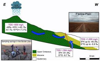
The F'Kirina plain in eastern Algeria is an endorheic basin suffering water scarcity due to a combination of natural and man-made causes. Its hydrogeological system is complex as made by interconnected aquifers represented by Mesozoic, Cenozoic, and Quaternary lithological units. The combination of drought indicators and water level data shows that a groundwater drought affected the plain during the last 15 years, which reflects on current water quality. The reported geochemical analyses, including major ions and trace elements, indicate that the groundwater resource is suffering from salinization, mainly due to evaporation and leaching of soil salts, a process that is coupled with simultaneous cation-exchange effects. In this framework, we observe a geochemical evolution from the fresh Ca–HCO3 facies, typical of springs bordering the plain, towards more saline groundwater characterized by chloride/sulphate-rich facies in the middle of the plain approaching the sebka. However, geochemical diagrams indicate that in few wells salinization is also influenced by upraising of deep groundwater. The water isotopic composition of the F'Kirina plain samples suggests that they diversely record both recharge and evaporation components. Moreover, the most 18O and D depleted compositions among the investigated ground-waters suggest recharge contributions by comparatively higher elevation or the involvement of old (fossil) water components.
中文翻译:
F'Kirina平原(阿尔及利亚东部)地下水的水文地质和地球化学特征
阿尔及利亚东部的F'Kirina平原是一个内生流域,由于自然原因和人为原因共同造成水资源短缺。它的水文地质系统是复杂的,由中生代,新生代和第四纪岩性单元代表的相互连接的含水层构成。干旱指标和水位数据的结合表明,在过去的15年中,地下水干旱影响了平原,这反映了当前的水质。已报告的地球化学分析(包括主要离子和微量元素)表明,地下水资源正遭受盐碱化的影响,这主要归因于土壤盐分的蒸发和浸出,这一过程与同时发生的阳离子交换效应相结合。在此框架下,我们观察到了新鲜Ca–HCO 3的地球化学演化。岩相通常是与平原接壤的泉水,流向盐度较高的地下水,其特征是在靠近塞布卡的平原中部富含氯化物/硫酸盐。但是,地球化学图表明,在少数几口井中,盐碱化还受到深层地下水上升的影响。F'Kirina平原样品的水同位素组成表明,它们以多种方式记录补给和蒸发成分。此外,在研究的地下水中,O和D消耗最多的18种成分表明,相对较高的海拔高度或旧的(化石)水成分参与了补给作用。


 京公网安备 11010802027423号