当前位置:
X-MOL 学术
›
Hydrol. Process.
›
论文详情
Our official English website, www.x-mol.net, welcomes your
feedback! (Note: you will need to create a separate account there.)
Monitoring and modelling of hydrological processes in the semiarid region of Brazil: The Cariri experimental basins
Hydrological Processes ( IF 2.8 ) Pub Date : 2021-04-28 , DOI: 10.1002/hyp.14194 Vajapeyam S. Srinivasan 1 , Hugo M. de Alcântara 2 , Carlos de O. Galvão 1 , Ulisses A. Bezerra 1 , John E. de Brito Leite Cunha 2
Hydrological Processes ( IF 2.8 ) Pub Date : 2021-04-28 , DOI: 10.1002/hyp.14194 Vajapeyam S. Srinivasan 1 , Hugo M. de Alcântara 2 , Carlos de O. Galvão 1 , Ulisses A. Bezerra 1 , John E. de Brito Leite Cunha 2
Affiliation
|
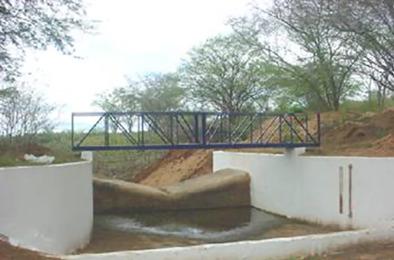
Catchments have highly variable yields of runoff and soil erosion. The size, land use and the surface cover play a significant role and influence the catchment response and parameter values of simulation models. Two experimental basins—the Cariri basins—were equipped in a semi-arid region of Brazil, for obtaining runoff and sediment yield at different catchment scales, as well as, to evaluate the influence of the land use and surface cover. In the first basin, located in the municipality of Sumé, the field studies were carried out at two different scales: four micro-catchments with an area of around 0.5 ha and nine standard Wischmeier-type erosion plots of 100 m2. The experimental units had varied vegetation and management. They were subjected only to natural rainfall events, and were monitored from 1982 to 1991. The total runoff and total sediment yield were determined for each of the events. The installations in the second basin, in the municipality of São João do Cariri, from 1999, include two erosion plots, three micro-catchments, and two sub-catchments of a small basin. These basins are still being monitored for runoff and sediment production. Among the micro-catchments two are nested to detect any scale effect at the micro-catchment level. Nearly 600 events of precipitation, that produced runoff in at least one of the experimental units, have been registered. These data have been used to evaluate the influence of various factors, including cultivation practices and to calibrate hydrological models for plots and micro-catchments. Parameters have been tested by means of cross validations among micro-catchments and sub-catchments. The data sets are made available to all the catchment hydrology researchers and others at https://doi.org/10.5281/zenodo.4690886.
中文翻译:

巴西半干旱地区的水文过程监测与建模:卡里里实验盆地
集水区的径流和土壤侵蚀产量变化很大。规模,土地利用和地表覆盖起着重要作用,并影响流域响应和模拟模型的参数值。在巴西的半干旱地区装备了两个实验盆地-卡里里盆地,以获取不同集水规模的径流和沉积物产量,以及评估土地利用和地表覆盖的影响。在位于苏梅市的第一个盆地中,进行了两个不同规模的实地研究:四个面积约0.5公顷的微型集水区和九个100 m 2的标准Wischmeier型侵蚀区。实验单位的植被和管理方式各异。它们仅受到自然降雨事件的影响,并在1982年至1991年期间受到监测。确定了每个事件的总径流量和总沉积物产量。从1999年起在圣若昂杜卡里里(SãoJoãodo Cariri)市的第二个盆地中的设施包括一个小盆地的两个侵蚀区,三个微型集水区和两个子集水区。这些盆地仍在监测径流和沉积物的产生。在微型集水区之间嵌套两个,以检测微型集水区水平上的任何水垢效应。已经记录了将近600个降水事件,这些降水事件至少在一个实验单位中产生了径流。这些数据已用于评估各种因素的影响,包括耕作方法和校准样地和小流域的水文模型。参数已通过微型集水区和子集水区之间的交叉验证进行了测试。这些数据集可在https://doi.org/10.5281/zenodo.4690886中提供给所有流域水文学研究人员和其他人员。
更新日期:2021-05-22
中文翻译:
巴西半干旱地区的水文过程监测与建模:卡里里实验盆地
集水区的径流和土壤侵蚀产量变化很大。规模,土地利用和地表覆盖起着重要作用,并影响流域响应和模拟模型的参数值。在巴西的半干旱地区装备了两个实验盆地-卡里里盆地,以获取不同集水规模的径流和沉积物产量,以及评估土地利用和地表覆盖的影响。在位于苏梅市的第一个盆地中,进行了两个不同规模的实地研究:四个面积约0.5公顷的微型集水区和九个100 m 2的标准Wischmeier型侵蚀区。实验单位的植被和管理方式各异。它们仅受到自然降雨事件的影响,并在1982年至1991年期间受到监测。确定了每个事件的总径流量和总沉积物产量。从1999年起在圣若昂杜卡里里(SãoJoãodo Cariri)市的第二个盆地中的设施包括一个小盆地的两个侵蚀区,三个微型集水区和两个子集水区。这些盆地仍在监测径流和沉积物的产生。在微型集水区之间嵌套两个,以检测微型集水区水平上的任何水垢效应。已经记录了将近600个降水事件,这些降水事件至少在一个实验单位中产生了径流。这些数据已用于评估各种因素的影响,包括耕作方法和校准样地和小流域的水文模型。参数已通过微型集水区和子集水区之间的交叉验证进行了测试。这些数据集可在https://doi.org/10.5281/zenodo.4690886中提供给所有流域水文学研究人员和其他人员。


 京公网安备 11010802027423号