Catena ( IF 5.4 ) Pub Date : 2021-04-28 , DOI: 10.1016/j.catena.2021.105379 Josip Terzić , Damir Grgec , Jasmina Lukač Reberski , Ana Selak , Ivana Boljat , Marina Filipović
|
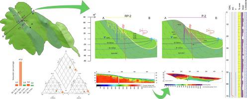
Ilovik is one of the smallest inhabited islands (5.51 km2) in the Adriatic Sea. It is composed of karstified Cretaceous and Paleogene limestones. Despite its small size, the island was the subject of an extensive research program.
The main objective was setting up a groundwater extraction site to extract brackish groundwater at a rate of least 1.0 L/s with chloride concentrations below 5000 mg/L.
The research was carried out in three phases using various methods: geological and hydrogeological mapping, geophysical profiling (electrical tomography and seismic refraction), investigatory core drilling, test-well design, pumping tests, groundwater level monitoring, and hydrogeochemical analyses (in situ and laboratory tests). The underground spread of electrical resistivity mapped the groundwater level and transition zone from fresh to brackish water, and seismic velocities indicated fractured zones. After the pumping tests, hydraulic parameters were calculated based on calculations for similar karstic aquifers, and hydraulic conductivity was within orders of magnitude of 10−4–10−6 m/s. The results have great applicability, as the water quantity and quality were determined. Additionally, parametric estimation of the hydrogeological properties was useful even in heterogeneous Dinaric karst environments. Such karst environments have to be studied via several different methods, with common interpretation, to avoid ambiguous conclusions.
中文翻译:
迪纳里克喀斯特小岛咸淡水晶状体的水文地质估计:克罗地亚Ilovik案例研究
伊洛维克(Ilovik )是亚得里亚海最小的有人居住的岛屿之一(5.51 km 2)。它由喀斯特白垩纪和古近系石灰岩组成。尽管面积很小,但该岛还是一项广泛的研究计划的主题。
主要目标是建立一个地下水提取站点,以至少1.0 L / s的速率提取含盐地下水,氯化物浓度低于5000 mg / L。
该研究分三个阶段使用各种方法进行:地质和水文地质测绘,地球物理分布图(电层析成像和地震折射),调查岩心钻探,测试井设计,抽水试验,地下水位监测以及水文地球化学分析(原位和实地分析)。实验室测试)。地下电阻率分布图绘制了地下水位和从淡水到微咸水的过渡带,地震速度指示了裂缝带。抽水试验后,基于对类似岩溶含水层的计算,计算了水力参数,水力传导率在10 -4 –10 -6数量级内 小姐。由于确定了水的数量和质量,因此该结果具有很大的适用性。此外,即使在非均质的Dinaric喀斯特环境中,水文地质特性的参数估计也很有用。为了避免模棱两可的结论,必须通过几种不同的方法对这种喀斯特环境进行研究,并且要有共同的解释。


 京公网安备 11010802027423号