当前位置:
X-MOL 学术
›
Hydrol. Process.
›
论文详情
Our official English website, www.x-mol.net, welcomes your
feedback! (Note: you will need to create a separate account there.)
Quantifying snow water equivalent using terrestrial ground penetrating radar and unmanned aerial vehicle photogrammetry
Hydrological Processes ( IF 2.8 ) Pub Date : 2021-04-25 , DOI: 10.1002/hyp.14190 Semih Yildiz 1 , Zuhal Akyurek 1, 2 , Andrew Binley 3
Hydrological Processes ( IF 2.8 ) Pub Date : 2021-04-25 , DOI: 10.1002/hyp.14190 Semih Yildiz 1 , Zuhal Akyurek 1, 2 , Andrew Binley 3
Affiliation
|
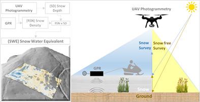
This study demonstrates the potential value of a combined unmanned aerial vehicle (UAV) Photogrammetry and ground penetrating radar (GPR) approach to map snow water equivalent (SWE) over large scales. SWE estimation requires two different physical parameters (snow depth and density), which are currently difficult to measure with the spatial and temporal resolution desired for basin-wide studies. UAV photogrammetry can provide very high-resolution spatially continuous snow depths (SD) at the basin scale, but does not measure snow densities. GPR allows nondestructive quantitative snow investigation if the radar velocity is known. Using photogrammetric snow depths and GPR two-way travel times (TWT) of reflections at the snow-ground interface, radar velocities in snowpack can be determined. Snow density (RSN) is then estimated from the radar propagation velocity (which is related to electrical permittivity of snow) via empirical formulas. A Phantom-4 Pro UAV and a MALA GX450 HDR model GPR mounted on a ski mobile were used to determine snow parameters. A snow-free digital surface model (DSM) was obtained from the photogrammetric survey conducted in September 2017. Then, another survey in synchronization with a GPR survey was conducted in February 2019 whilst the snowpack was approximately at its maximum thickness. Spatially continuous snow depths were calculated by subtracting the snow-free DSM from the snow-covered DSM. Radar velocities in the snowpack along GPR survey lines were computed by using UAV-based snow depths and GPR reflections to obtain snow densities and SWEs. The root mean square error of the obtained SWEs (384 mm average) is 63 mm, indicating good agreement with independent SWE observations and the error lies within acceptable uncertainty limits.
中文翻译:

使用地面探地雷达和无人机摄影测量法对雪水当量进行量化
这项研究表明,结合无人机摄影测量法和探地雷达(GPR)方法在大尺度上绘制雪水当量(SWE)的潜在价值。SWE估算需要两个不同的物理参数(雪深和密度),目前很难用流域范围研究所需的时空分辨率来测量。无人机摄影测量可以在流域尺度上提供非常高分辨率的空间连续降雪深度(SD),但不能测量降雪密度。如果知道雷达速度,GPR可以进行无损定量雪雪调查。使用摄影测量的雪深和雪地界面反射的GPR双向传播时间(TWT),可以确定积雪中的雷达速度。然后通过经验公式根据雷达传播速度(与雪的介电常数有关)估算雪密度(RSN)。安装在滑雪板上的Phantom-4 Pro无人机和MALA GX450 HDR GPR模型被用来确定降雪参数。从2017年9月进行的摄影测量中获得了无雪数字表面模型(DSM)。然后,在2019年2月进行了与GPR测量同步的另一次测量,当时雪堆的厚度约为其最大厚度。通过从积雪的DSM中减去无雪的DSM,可以计算出空间连续的积雪深度。通过使用基于无人机的降雪深度和GPR反射来计算沿GPR测量线的积雪中的雷达速度,以获得积雪密度和SWE。
更新日期:2021-05-22
中文翻译:
使用地面探地雷达和无人机摄影测量法对雪水当量进行量化
这项研究表明,结合无人机摄影测量法和探地雷达(GPR)方法在大尺度上绘制雪水当量(SWE)的潜在价值。SWE估算需要两个不同的物理参数(雪深和密度),目前很难用流域范围研究所需的时空分辨率来测量。无人机摄影测量可以在流域尺度上提供非常高分辨率的空间连续降雪深度(SD),但不能测量降雪密度。如果知道雷达速度,GPR可以进行无损定量雪雪调查。使用摄影测量的雪深和雪地界面反射的GPR双向传播时间(TWT),可以确定积雪中的雷达速度。然后通过经验公式根据雷达传播速度(与雪的介电常数有关)估算雪密度(RSN)。安装在滑雪板上的Phantom-4 Pro无人机和MALA GX450 HDR GPR模型被用来确定降雪参数。从2017年9月进行的摄影测量中获得了无雪数字表面模型(DSM)。然后,在2019年2月进行了与GPR测量同步的另一次测量,当时雪堆的厚度约为其最大厚度。通过从积雪的DSM中减去无雪的DSM,可以计算出空间连续的积雪深度。通过使用基于无人机的降雪深度和GPR反射来计算沿GPR测量线的积雪中的雷达速度,以获得积雪密度和SWE。


 京公网安备 11010802027423号