当前位置:
X-MOL 学术
›
Hydrol. Process.
›
论文详情
Our official English website, www.x-mol.net, welcomes your
feedback! (Note: you will need to create a separate account there.)
Multi‐year observations of the high mountain water cycle in the Langtang catchment, Central Himalaya
Hydrological Processes ( IF 2.8 ) Pub Date : 2021-04-25 , DOI: 10.1002/hyp.14189 Jakob F Steiner 1, 2 , Tika R Gurung 2 , Sharad P Joshi 2 , Inka Koch 2 , Tuomo Saloranta 3 , Joseph Shea 4 , Arun B Shrestha 2 , Emmy Stigter 1 , Walter W Immerzeel 1
Hydrological Processes ( IF 2.8 ) Pub Date : 2021-04-25 , DOI: 10.1002/hyp.14189 Jakob F Steiner 1, 2 , Tika R Gurung 2 , Sharad P Joshi 2 , Inka Koch 2 , Tuomo Saloranta 3 , Joseph Shea 4 , Arun B Shrestha 2 , Emmy Stigter 1 , Walter W Immerzeel 1
Affiliation
|
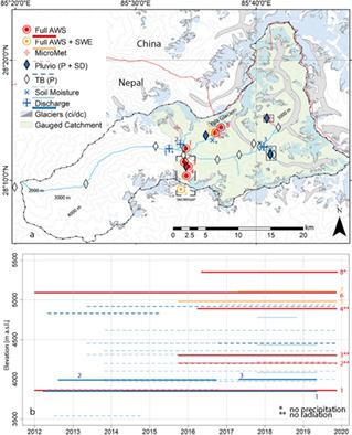
The Langtang catchment is a high mountain, third order catchment in the Gandaki basin in the Central Himalaya (28.2°N, 85.5°E), that eventually drains into the Ganges. The catchment spans an elevation range from 1400 to 7234 m a.s.l. and approximately one quarter of the area is glacierized. Numerous research projects have been conducted in the valley during the last four decades, with a strong focus on the cryospheric components of the catchment water balance. Since 2012 multiple weather stations and discharge stations provide measurements of atmospheric and hydrologic variables. Full weather stations are used to monitor at an hourly resolution all four radiation components (incoming and outgoing shortwave and longwave radiation; SWin/out and LWin/out), air temperature, humidity, wind speed and direction, and precipitation, and cover an elevational range of 3862–5330 m a.s.l. Air temperature and precipitation are monitored along elevation gradients for investigations of the spatial variability of the high mountain meteorology. Dedicated point‐scale observations of snow cover, depth and water equivalent as well as ice loss have been carried out over multiple years and complement the observations of the water cycle. All data presented is openly available in a database and will be updated annually.
中文翻译:

喜马拉雅中部朗塘流域高山水循环的多年观测
朗塘流域是喜马拉雅山中部甘达基盆地(北纬 28.2°,东经 85.5°)的一座高山三级流域,最终流入恒河。流域海拔从 1400 米到 7234 米不等,大约四分之一的面积被冰川覆盖。过去四十年来,该山谷开展了许多研究项目,重点关注流域水平衡的冰冻圈组成部分。自 2012 年以来,多个气象站和排放站提供大气和水文变量的测量。完整的气象站用于以每小时的分辨率监测所有四个辐射分量(传入和传出的短波和长波辐射;SW输入/输出和 LW输入/输出)、气温、湿度、风速和风向、降水量和覆盖率海拔范围为 3862–5330 m asl 沿着海拔梯度监测气温和降水,以研究高山气象的空间变化。多年来对积雪、深度、水当量以及冰损失进行了专门的点尺度观测,并补充了水循环的观测。所有提供的数据都在数据库中公开提供,并将每年更新。
更新日期:2021-05-17
中文翻译:
喜马拉雅中部朗塘流域高山水循环的多年观测
朗塘流域是喜马拉雅山中部甘达基盆地(北纬 28.2°,东经 85.5°)的一座高山三级流域,最终流入恒河。流域海拔从 1400 米到 7234 米不等,大约四分之一的面积被冰川覆盖。过去四十年来,该山谷开展了许多研究项目,重点关注流域水平衡的冰冻圈组成部分。自 2012 年以来,多个气象站和排放站提供大气和水文变量的测量。完整的气象站用于以每小时的分辨率监测所有四个辐射分量(传入和传出的短波和长波辐射;SW输入/输出和 LW输入/输出)、气温、湿度、风速和风向、降水量和覆盖率海拔范围为 3862–5330 m asl 沿着海拔梯度监测气温和降水,以研究高山气象的空间变化。多年来对积雪、深度、水当量以及冰损失进行了专门的点尺度观测,并补充了水循环的观测。所有提供的数据都在数据库中公开提供,并将每年更新。


 京公网安备 11010802027423号