当前位置:
X-MOL 学术
›
Hydrol. Process.
›
论文详情
Our official English website, www.x-mol.net, welcomes your feedback! (Note: you will need to create a separate account there.)
Long-term hydrology and aquatic biogeochemistry data from H. J. Andrews Experimental Forest, Cascade Mountains, Oregon
Hydrological Processes ( IF 3.2 ) Pub Date : 2021-04-25 , DOI: 10.1002/hyp.14187 Sherri L. Johnson 1 , Don Henshaw 1 , Greg Downing 1 , Steve Wondzell 1 , Mark Schulze 2 , Adam Kennedy 2 , Greg Cohn 2 , Stephanie A. Schmidt 1 , Julia A. Jones 3
Hydrological Processes ( IF 3.2 ) Pub Date : 2021-04-25 , DOI: 10.1002/hyp.14187 Sherri L. Johnson 1 , Don Henshaw 1 , Greg Downing 1 , Steve Wondzell 1 , Mark Schulze 2 , Adam Kennedy 2 , Greg Cohn 2 , Stephanie A. Schmidt 1 , Julia A. Jones 3
Affiliation
|
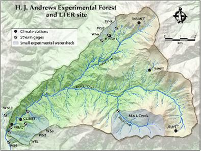
The H. J. Andrews Experimental Forest (HJA) encompasses the 6400 ha Lookout Creek watershed in western Oregon, USA. Hydrologic, chemistry and precipitation data have been collected, curated, and archived for up to 70 years. The HJA was established in 1948 to study the effects of harvest of old-growth conifer forest and logging-road construction on water quality, quantity and vegetation succession. Over time, research questions have expanded to include terrestrial and aquatic species, communities and ecosystem dynamics. There are nine small experimental watersheds and 10 gaging stations in the HJA, including both reference and experimentally treated watersheds. Gaged watershed areas range from 8.5 to 6242 ha. All gaging stations record stage height, water conductivity, water temperature and above-stream air temperature. At nine of the gage sites, flow-proportional water samples are collected and composited over 3-week intervals for chemical analysis. Analysis of stream and precipitation chemistry began in 1968. Analytes include dissolved and particulate species of nitrogen and phosphorus, dissolved organic carbon, pH, specific conductance, suspended sediment, alkalinity, and major cations and anions. Supporting climate measurements began in the 1950s in association with the first small watershed experiments. Over time, and following the initiation of the Long Term Ecological Research (LTER) grant in 1980, infrastructure expanded to include a set of benchmark and secondary meteorological stations located in clearings spanning the elevation range within the Lookout Creek watershed, as well as a large number of forest understory temperature stations. Extensive metadata on sensor configurations, changes in methods over time, sensor accuracy and precision, and data quality control flags are associated with the HJA data.
中文翻译:

来自俄勒冈州喀斯喀特山脉HJ安德鲁斯实验森林的长期水文和水生生物地球化学数据
HJ安德鲁斯实验森林(HJA)涵盖了美国俄勒冈州西部6400公顷的Lookout Creek流域。水文,化学和降水数据已收集,整理和存档长达70年。HJA成立于1948年,旨在研究采伐旧针叶林和伐木道路对水质,水量和植被演替的影响。随着时间的流逝,研究问题已经扩展到包括陆生和水生物种,群落和生态系统动态。HJA中有9个小型实验流域和10个测量站,包括参考流域和经过实验处理的流域。有标尺的流域面积在8.5到6242公顷之间。所有计量站均记录平台高度,水电导率,水温和上游空气温度。在九个量具站点中,流量成比例的水样本将在3周的时间间隔内收集并合成以进行化学分析。流和沉淀化学的分析始于1968年。分析物包括氮和磷的溶解和颗粒物,溶解的有机碳,pH,比电导,悬浮沉积物,碱度以及主要的阳离子和阴离子。支持气候的测量始于1950年代,是第一个小流域实验的结合。随着时间的流逝,继1980年启动长期生态研究(LTER)赠款后,基础设施扩展到包括一套基准和辅助气象站,这些站位于跨越Lookout Creek流域高程范围的空地中,森林地下温度站的数量。
更新日期:2021-05-22
中文翻译:
来自俄勒冈州喀斯喀特山脉HJ安德鲁斯实验森林的长期水文和水生生物地球化学数据
HJ安德鲁斯实验森林(HJA)涵盖了美国俄勒冈州西部6400公顷的Lookout Creek流域。水文,化学和降水数据已收集,整理和存档长达70年。HJA成立于1948年,旨在研究采伐旧针叶林和伐木道路对水质,水量和植被演替的影响。随着时间的流逝,研究问题已经扩展到包括陆生和水生物种,群落和生态系统动态。HJA中有9个小型实验流域和10个测量站,包括参考流域和经过实验处理的流域。有标尺的流域面积在8.5到6242公顷之间。所有计量站均记录平台高度,水电导率,水温和上游空气温度。在九个量具站点中,流量成比例的水样本将在3周的时间间隔内收集并合成以进行化学分析。流和沉淀化学的分析始于1968年。分析物包括氮和磷的溶解和颗粒物,溶解的有机碳,pH,比电导,悬浮沉积物,碱度以及主要的阳离子和阴离子。支持气候的测量始于1950年代,是第一个小流域实验的结合。随着时间的流逝,继1980年启动长期生态研究(LTER)赠款后,基础设施扩展到包括一套基准和辅助气象站,这些站位于跨越Lookout Creek流域高程范围的空地中,森林地下温度站的数量。


 京公网安备 11010802027423号