Geoscience Frontiers ( IF 8.5 ) Pub Date : 2021-04-24 , DOI: 10.1016/j.gsf.2021.101206 Sumit Das , Amitesh Gupta
|
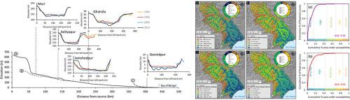
The Subarnarekha River in east India experiences frequent high magnitude flooding in monsoon season. In this study, we present an in-depth analysis of flood hydrology and GIS-based flood susceptibility mapping of the entire catchment. About 40 years of annual peak discharge data, historical cross-sections of different gauging sites, and 12 flood conditioning factors were considered. Our flood susceptibility mapping followed an expert knowledge-based multi-parametric analytical hierarchy process (AHP) and optimized AHP-VIP methods. Peak hydrology data indicated more than 5 times higher discharge contrasted with the mean streamflow of the peak monsoon month in all hydro-monitoring stations that correspond to possible overbank flooding in the shallow semi-alluvial reaches of the Subarnarekha River. Width-depth ratio revealed continuous changes on the channel cross-sections at decadal scale in all gauging sites. Predicted flood susceptibility map through optimized AHP-VIP method showed a great amount of areas (38%) have a high probability of flooding and demands earnest attention of administrative bodies. The AHP-VIP based flood susceptibility map was theoritically validated through AUC approach and it showed fairly high accuracy (AUC = 0.93). Our study offers an exceptionally cost and time effective solution to the flooding issues in the Subarnarekha basin.
中文翻译:
基于多准则决策的印度Subarnarekha盆地洪水敏感性和时变水地貌变化的地理空间映射
印度东部的Subarnarekha河在季风季节经常发生大洪水。在这项研究中,我们对整个流域的洪水水文学和基于GIS的洪水敏感性地图进行了深入分析。考虑了大约40年的年度峰值流量数据,不同测量地点的历史剖面以及12个洪水调节因素。我们的洪水敏感性制图遵循基于专家知识的多参数分析层次结构过程(AHP)和优化的AHP-VIP方法。峰值水文学数据表明,与所有季风季的平均季流量相比,所有水监测站的流量都高出5倍以上,这与Subarnarekha河浅半冲积河段可能发生的河滩泛滥相对应。宽深比表明,在所有测量地点,通道横截面都以十年尺度连续变化。通过优化的AHP-VIP方法预测的洪水敏感性图表明,大量地区(38%)发生洪水的可能性很高,需要行政管理部门的认真关注。理论上通过AUC方法对基于AHP-VIP的洪水敏感性图进行了验证,该图显示了相当高的精度(AUC = 0.93)。我们的研究为Subarnarekha盆地的洪水问题提供了一种成本有效且时间有效的解决方案。理论上通过AUC方法对基于AHP-VIP的洪水敏感性图进行了验证,该图显示了相当高的精度(AUC = 0.93)。我们的研究为Subarnarekha盆地的洪水问题提供了一种成本有效且时间有效的解决方案。理论上通过AUC方法对基于AHP-VIP的洪水敏感性图进行了验证,该图显示了相当高的精度(AUC = 0.93)。我们的研究为Subarnarekha盆地的洪水问题提供了一种成本有效且时间有效的解决方案。


 京公网安备 11010802027423号