Journal of Volcanology and Geothermal Research ( IF 2.4 ) Pub Date : 2021-04-21 , DOI: 10.1016/j.jvolgeores.2021.107255 Ruli Andaru , Jiann Yeou Rau , Devy Kamil Syahbana , Ardy Setya Prayoga , Heruningtyas Desi Purnamasari
|
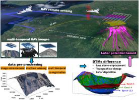
Mount Agung (the highest volcano in Bali, Indonesia) began to erupt on November 21, 2017, after having been dormant for 53 years. More than 100,000 people were evacuated within the hazard zone between September 2017 (when the highest volcanic alert was issued) and early 2018. The eruptions continued until June 2019, accompanied by at least 110 explosions. During the eruptive crisis, the observation of the lava dome's emplacement was essential for mitigating the potential hazard. Details of the lava dome growth, including the volumetric changes and effusion rates, provide valuable information about potential eruption scenarios and lahar depositions. In this paper, the essential role of multi-temporal unmanned aerial vehicle (UAV) images in the monitoring of Mt. Agung's lava dome, and in determining the areas of potential lahar hazards during the crisis between 2017 and 2019 is described. A fixed-wing UAV was launched outside the hazard zone to photograph the lava dome on five occasions. Image enhancement, machine learning, and photogrammetry were combined to improve image quality, remove point clouds outliers, and generate digital terrain models (DTMs) and orthoimages. The analysis of the obtained DTMs and orthoimages resulted in qualitative and quantitative data highlighting the changes inside the crater and on the surrounding slopes. These results reveal that, from November 25 to December 16, 2017, the lava dome grew vertically by 126 m and reached a volume of 26.86 ± 0.64 × 10⁶ m3. In addition, its surface experienced a maximal uplift of approximately 52 m until July 2019 with the emergence of a new dome with a volume estimated at 9.52 ± 0.086 × 10⁶ m3. The difference between the DTMs of 2017 and 2019 reveals the total volume of erupted material (886,100 ± 8000 m3) that was deposited on the surrounding slopes. According to the lahar inundation simulation, the deposited material may cause dangerous lahars in 21 drainages, which extend in the north (N), north-east (N-E), south (S), south-east (S-E), and south-west (S-W) sectors of the volcano. This paper presents the use of UAV remote sensing for the production of high-spatial resolution DTMs, which can be used to both observe the emplacement of a lava dome, and to identify areas with potential lahar risk during a volcano crisis.
中文翻译:
使用无人机遥感观测熔岩穹顶的位置和潜在的拉哈尔灾害区域:以巴厘岛阿贡山2017-2019年喷发危机为例
在休眠了53年之后,阿贡山(印度尼西亚巴厘岛最高的火山)于2017年11月21日开始爆发。在2017年9月(发布最高火山警报)至2018年初之间,有10万人被疏散在危险区内。爆发持续至2019年6月,至少发生110起爆炸。在爆发危机期间,观察熔岩穹顶的位置对于减轻潜在危害至关重要。熔岩穹顶生长的详细信息,包括体积变化和积水速率,可提供有关潜在喷发情况和拉哈沉积的有价值的信息。在本文中,多时空无人机(UAV)图像在Mt监测中的重要作用。阿贡的熔岩穹顶 并确定了2017年至2019年危机期间潜在的Lahar危害区域。一架固定翼无人机在危险区域外发射,以五次拍摄熔岩穹顶。图像增强,机器学习和摄影测量技术相结合,以提高图像质量,消除点云离群值并生成数字地形模型(DTM)和正射影像。对获得的DTM和正射影像的分析得出定性和定量数据,突出了陨石坑内部和周围斜坡的变化。这些结果表明,从2017年11月25日到12月16日,熔岩穹顶垂直增长126 m,体积达到26.86±0.64×10 一架固定翼无人机在危险区域外发射,以五次拍摄熔岩穹顶。图像增强,机器学习和摄影测量技术相结合,以提高图像质量,消除点云离群值并生成数字地形模型(DTM)和正射影像。对获得的DTM和正射影像的分析得出定性和定量数据,突出了陨石坑内部和周围斜坡的变化。这些结果表明,从2017年11月25日到12月16日,熔岩穹顶垂直增长126 m,体积达到26.86±0.64×10 一架固定翼无人机在危险区域外发射,以五次拍摄熔岩穹顶。图像增强,机器学习和摄影测量技术相结合,以提高图像质量,消除点云离群值并生成数字地形模型(DTM)和正射影像。对获得的DTM和正射影像的分析得出定性和定量数据,突出了陨石坑内部和周围斜坡的变化。这些结果表明,从2017年11月25日到12月16日,熔岩穹顶垂直增长126 m,体积达到26.86±0.64×10 对获得的DTM和正射影像的分析得出定性和定量数据,突出了陨石坑内部和周围斜坡的变化。这些结果表明,从2017年11月25日到12月16日,熔岩穹顶垂直增长126 m,体积达到26.86±0.64×10 对获得的DTM和正射影像的分析得出定性和定量数据,突出了陨石坑内部和周围斜坡的变化。这些结果表明,从2017年11月25日到12月16日,熔岩穹顶垂直增长126 m,体积达到26.86±0.64×10⁶ m 3。此外,直到2019年7月,随着新穹顶的出现,其表面经历了大约52 m的最大隆起,体积估计为9.52±0.086×10 6 m 3。2017年和2019年DTM之间的差异揭示了喷发物质的总体积(886,100±8000 m 3)沉积在周围的斜坡上。根据Lahar淹没模拟,沉积的物质可能会在21条排水管中造成危险的Lahar,这些排水管在北部(N),东北(NE),南部(S),东南(SE)和西南延伸(SW)火山的扇区。本文介绍了使用无人机遥感技术生产高空间分辨率的DTM,该DTM可用于观察熔岩穹顶的位置,并识别火山爆发期间可能存在拉哈尔风险的区域。


 京公网安备 11010802027423号