当前位置:
X-MOL 学术
›
Hydrol. Process.
›
论文详情
Our official English website, www.x-mol.net, welcomes your
feedback! (Note: you will need to create a separate account there.)
Influence of groundwater and topography on stream drying in semi‐arid headwater streams
Hydrological Processes ( IF 2.8 ) Pub Date : 2021-04-21 , DOI: 10.1002/hyp.14185 Sara R. Warix 1 , Sarah E. Godsey 1 , Kathleen A. Lohse 1, 2 , Rebecca L. Hale 2
Hydrological Processes ( IF 2.8 ) Pub Date : 2021-04-21 , DOI: 10.1002/hyp.14185 Sara R. Warix 1 , Sarah E. Godsey 1 , Kathleen A. Lohse 1, 2 , Rebecca L. Hale 2
Affiliation
|
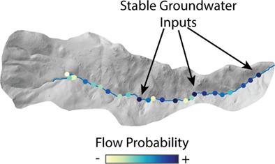
Non‐perennial streams comprise over half of the global stream network and impact downstream water quality. Although aridity is a primary driver of stream drying globally, surface flow permanence varies spatially and temporally within many headwater streams, suggesting that these complex drying patterns may be driven by topographic and subsurface factors. Indeed, these factors affect shallow groundwater flows in perennial systems, but there has been only limited characterisation of shallow groundwater residence times and groundwater contributions to intermittent streams. Here, we asked how groundwater residence times, shallow groundwater contributions to streamflow, and topography interact to control stream drying in headwater streams. We evaluated this overarching question in eight semi‐arid headwater catchments based on surface flow observations during the low‐flow period, coupled with tracer‐based groundwater residence times. For one headwater catchment, we analysed stream drying during the seasonal flow recession and rewetting period using a sensor network that was interspersed between groundwater monitoring locations, and linked drying patterns to groundwater inputs and topography. We found a poor relationship between groundwater residence times and flowing network extent (R2 < 0.24). Although groundwater residence times indicated that old groundwater was present in all headwater streams, surface drying also occurred in each of them, suggesting old, deep flowpaths are insufficient to sustain surface flows. Indeed, the timing of stream drying at any given point typically coincided with a decrease in the contribution from near‐surface sources and an increased relative contribution of groundwater to streamflow at that location, whereas the spatial pattern of drying within the stream network typically correlated with locations where groundwater inputs were most seasonally variable. Topographic metrics only explained ~30% of the variability in seasonal flow permanence, and surprisingly, we found no correlation with seasonal drying and down‐valley subsurface storage area. Because we found complex spatial patterns, future studies should pair dense spatial observations of subsurface properties, such as hydraulic conductivity and transmissivity, to observations of seasonal flow permanence.
中文翻译:

地下水和地形对半干旱上游水流干燥的影响
非常年性河流占全球河流网络的一半以上,并影响下游水质。尽管干旱是全球河床干燥的主要驱动力,但地表水的持久性在许多源头水流中在空间和时间上都在变化,这表明这些复杂的干燥方式可能受地形和地下因素驱动。的确,这些因素影响多年生系统中的浅层地下水流量,但是浅层地下水停留时间和地下水对间歇流的贡献只有有限的特征。在这里,我们问了地下水停留时间,浅层地下水对水流的贡献以及地形如何相互作用以控制源头水流的干燥。我们根据低流量时期的地表水观测以及示踪剂对地下水的停留时间,在八个半干旱源头集水区评估了这一总体问题。对于一个水源流域,我们使用散布在地下水监测位置之间的传感器网络分析了季节性流量衰退和再湿润期间的河流干燥,并将干燥模式与地下水输入和地形联系在一起。我们发现地下水停留时间与流动网络范围之间的关系很差(并将干燥方式与地下水输入和地形联系起来。我们发现地下水停留时间与流动网络范围之间的关系很差(并将干燥方式与地下水输入和地形联系起来。我们发现地下水停留时间与流动网络范围之间的关系很差(R 2 <0.24)。尽管地下水的停留时间表明所有源头水流中都存在旧的地下水,但它们中的每一个也都发生了表面干燥,这表明旧的深层流径不足以维持地表水流。实际上,在任何给定点的河流干燥时间通常与近地表水源的贡献减少以及该位置的地下水对河流水流的相对贡献增加有关,而河流网络内的干燥空间格局通常与地下水输入量季节变化最大的位置。地形学指标仅解释了季节性流量永久性的约30%的变化,而且令人惊讶的是,我们发现与季节性干燥和河谷地下地下存储区域没有相关性。因为我们发现了复杂的空间格局,
更新日期:2021-05-12
中文翻译:
地下水和地形对半干旱上游水流干燥的影响
非常年性河流占全球河流网络的一半以上,并影响下游水质。尽管干旱是全球河床干燥的主要驱动力,但地表水的持久性在许多源头水流中在空间和时间上都在变化,这表明这些复杂的干燥方式可能受地形和地下因素驱动。的确,这些因素影响多年生系统中的浅层地下水流量,但是浅层地下水停留时间和地下水对间歇流的贡献只有有限的特征。在这里,我们问了地下水停留时间,浅层地下水对水流的贡献以及地形如何相互作用以控制源头水流的干燥。我们根据低流量时期的地表水观测以及示踪剂对地下水的停留时间,在八个半干旱源头集水区评估了这一总体问题。对于一个水源流域,我们使用散布在地下水监测位置之间的传感器网络分析了季节性流量衰退和再湿润期间的河流干燥,并将干燥模式与地下水输入和地形联系在一起。我们发现地下水停留时间与流动网络范围之间的关系很差(并将干燥方式与地下水输入和地形联系起来。我们发现地下水停留时间与流动网络范围之间的关系很差(并将干燥方式与地下水输入和地形联系起来。我们发现地下水停留时间与流动网络范围之间的关系很差(R 2 <0.24)。尽管地下水的停留时间表明所有源头水流中都存在旧的地下水,但它们中的每一个也都发生了表面干燥,这表明旧的深层流径不足以维持地表水流。实际上,在任何给定点的河流干燥时间通常与近地表水源的贡献减少以及该位置的地下水对河流水流的相对贡献增加有关,而河流网络内的干燥空间格局通常与地下水输入量季节变化最大的位置。地形学指标仅解释了季节性流量永久性的约30%的变化,而且令人惊讶的是,我们发现与季节性干燥和河谷地下地下存储区域没有相关性。因为我们发现了复杂的空间格局,


 京公网安备 11010802027423号