Journal of Asian Earth Sciences ( IF 2.7 ) Pub Date : 2021-04-19 , DOI: 10.1016/j.jseaes.2021.104782 Zakaria Hamimi , Mohamed Abdelkareem , Abdel-Rahman Fowler , Mohammed H. Younis , Mohammed Matsah , Fathy Abdalla
|
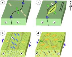
The Central Asir Shear Zone (CASZ) is a N- to NNE-oriented inhomogeneous strain zone parallel to the Nabitah shear belt in southern Saudi Arabia. It is ~200 km long and 20 km wide, and traverses the Asir terrane. The deformed terrains in the vicinity of the CASZ have experienced a prolonged history involving three successive phases of deformation: arc-collision, dextral transpression and sinistral strike-slip faulting. Remote-sensing data analysis and field investigation provide insights into the geological and structural features along the CASZ. Image transformation and enhancement reveal faults and folds, and discriminate between granitoids, metavolcanics, gabbros and younger (Ablah Group) sediments. The obtained evidence points to polyphase deformation of the area, characterized by narrow zones of high strain, folding and shearing enclosing slices of less deformed rocks. Lineament analysis shows predominantly NNE, NNW, N and NE trends of folds and shear zones, and NW, NE and E fracture trends. The CASZ has a >100 m.y. long deformation history, including a change from dextral to sinistral shearing. Both shearing senses are found on the older N-S and younger NW-SE fault systems. N-S oriented shearing was accompanied by intrusion of granitoids and localized hydrothermal alteration along N to NNE trending shear zones. Strain analysis shows low strain in the Ablah basin sediments, consistent with Ablah deposition after the tectonic climax in the region.
中文翻译:
阿拉伯盾牌西部地区Asir剪切带的遥感和结构研究:对新元古代EW冈瓦纳大会的启示
中央Asir剪切带(CASZ)是N-NNE定向的不均匀应变带,与沙特阿拉伯南部的Nabitah剪切带平行。它长约200公里,宽20公里,横穿Asir地表。CASZ附近的变形地形经历了很长的历史,涉及三个连续的变形阶段:电弧碰撞,右旋压制和左旋走滑断裂。遥感数据分析和现场调查提供了有关CASZ沿线地质和构造特征的见识。图像变换和增强显示出断层和褶皱,并区分了花岗岩,超火山,长辉石和较年轻的(Ablah集团)沉积物。获得的证据表明该区域为多相变形,其特征是高应变的狭窄区域,折叠并剪切变形较小的岩石的切片。线性分析显示褶皱和剪切带的主要是NNE,NNW,N和NE趋势,以及NW,NE和E断裂趋势。CASZ的变形历史超过100年,包括从右旋剪切到左鼻剪切的变化。在较老的NS和较年轻的NW-SE断层系统中都发现了两种剪切意义。NS定向剪切伴随着花岗岩的侵入和沿N到NNE趋势剪切带的局部热液蚀变。应变分析表明,阿拉伯盆地沉积物中的应变较低,与该地区构造高潮后的阿拉伯沉积一致。包括从右切变到左切变。在较老的NS和较年轻的NW-SE断层系统中都发现了两种剪切意义。NS定向剪切伴随着花岗岩的侵入和沿N到NNE趋势剪切带的局部热液蚀变。应变分析表明,阿拉伯盆地沉积物中的应变较低,与该地区构造高潮后的阿拉伯沉积一致。包括从右切变到左切变。在较老的NS和较年轻的NW-SE断层系统中都发现了两种剪切意义。NS定向剪切伴随着花岗岩的侵入和沿N到NNE趋势剪切带的局部热液蚀变。应变分析表明,阿拉伯盆地沉积物中的应变较低,与该地区构造高潮后的阿拉伯沉积一致。


 京公网安备 11010802027423号