Catena ( IF 5.4 ) Pub Date : 2021-04-18 , DOI: 10.1016/j.catena.2021.105354 Sana Khan , Kirstie A. Fryirs , Samuel Shumack
|
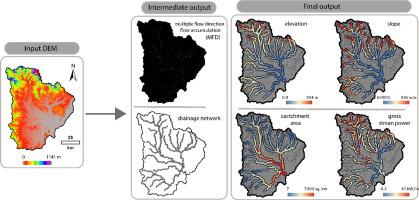
The global availability of Digital Elevation Models (DEMs) has enabled rapid, catchment scale geomorphic analysis of river systems. In this paper, we present a semi-automated GIS approach to quickly and accurately extract catchment scale geomorphic controls: slope, gross stream power and valley bottom width, and import bed material texture data along a drainage network. To enable rapid applicability of this approach, we provide the workflow for calculating elevation, slope, contributing catchment area and gross stream power embedded within ArcGIS toolkit, ArcGIS ModelBuilder and Python script as supplementary data. We also present an approach for disaggregating the drainage network and deciding the most appropriate reach length over which to calculate slope based on catchment topography. We demonstrate the importance of investigating DEM quality prior to use, strategic selection of the flow accumulation algorithm, and validation of the drainage network output using aerial imagery.
中文翻译:
使用公开可用的数据集,对河流多样性的集水规模地貌控制进行半自动计算
数字高程模型(DEM)在全球范围内的应用已经实现了对河流系统的快速,集水规模地貌分析。在本文中,我们提出了一种半自动化的GIS方法,可以快速而准确地提取集水规模的地貌控制:坡度,总流功率和谷底宽度,并沿排水网络导入床层质地数据。为了使这种方法能够快速适用,我们提供了工作流来计算作为辅助数据嵌入在ArcGIS工具包,ArcGIS ModelBuilder和Python脚本中的高程,坡度,集水区面积和总水流功率。我们还提出了一种方法,用于分解排水网络并确定最合适的河段长度,根据集水区的地形来计算坡度。


 京公网安备 11010802027423号