Earth, Planets and Space ( IF 3.0 ) Pub Date : 2021-04-16 , DOI: 10.1186/s40623-021-01415-2 Dinh Toan Vu , Sylvain Bonvalot , Sean Bruinsma , Luyen K. Bui
|
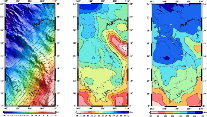
High-resolution Moho and lithosphere–asthenosphere boundary depth models for Vietnam and its surrounding areas are determined based on a recently released geoid model constructed from surface and satellite gravity data (GEOID_LSC_C model) and on 3ʹʹ resolution topography data (mixed SRTM model). A linear density gradient for the crust and a temperature-dependent density for the lithospheric mantle were used to determine the lithospheric structure under the assumption of local isostasy. In a first step, the impact of correcting elevation data from sedimentary basins to estimate Moho depth has been evaluated using CRUST1.0 model. Results obtained from a test area where seismic data are available, which demonstrated that the sedimentary effect should be considered before the inversion process. The geoid height and elevation-corrected sedimentary layer were filtered to remove signals originating below the lithosphere. The resulting Moho and lithosphere–asthenosphere boundary depth models computed at 1ʹ resolution were evaluated against seismic data as well as global and local lithospheric models available in the study region. These comparisons indicate a consistency of our Moho depth estimation with the seismic data within 1.5 km in standard deviation for the whole Vietnam. This new Moho depth model for the study region represents a significant improvement over the global models CRUST1.0 and GEMMA, which have standard deviations of 3.2 and 3.3 km, respectively, when compared to the seismic data. Even if a detailed geological interpretation of the results is out of scope of this paper, a joint analysis of the obtained models with the high-resolution Bouguer gravity anomaly is finally discussed in terms of the main geological patterns of the study region. The high resolution of our Moho and lithosphere–asthenosphere boundary depth models contribute to better constrain the lithospheric structure as well as tectonic and geodynamic processes of this region. The differences in Moho depth visible in the northeast and southwest sides of the Red River Fault Zone confirmed that the Red River Fault Zone may be considered the boundary between two continental blocks: South China and Indochina blocks. However, no remarkable differences in lithosphere–asthenosphere boundary depth were obtained from our results. This suggests that the Red River Fault Zone developed within the crust and remained a crustal fault.
中文翻译:
高分辨率重力大地水准面推导的越南当地岩石圈结构模型
越南及其周边地区的高分辨率Moho和岩石圈-软流圈边界深度模型是根据最近发布的基于地表和卫星重力数据的大地水准面模型(GEOID_LSC_C模型)和3分辨率的地形数据(混合SRTM模型)确定的。地壳的线性密度梯度和岩石圈地幔的随温度变化的密度被用来确定假设为局部等静态的岩石圈结构。第一步,使用CRUST1.0模型评估了校正沉积盆地高程数据以估算莫霍深度的影响。从可获得地震数据的测试区域获得的结果表明,在反演过程之前应考虑沉积作用。对大地水准面高度和经高程校正的沉积层进行过滤,以去除源自岩石圈以下的信号。根据地震数据以及研究区域可用的全球和局部岩石圈模型,对以1ʹ分辨率计算出的Moho和岩石圈-软流圈边界深度模型进行了评估。这些比较表明,整个越南的Moho深度估算值与标准差在1.5 km以内的地震数据保持一致。对于研究区域,这种新的Moho深度模型代表了对全球模型CRUST1.0和GEMMA的重大改进,与地震数据相比,CRUST1.0和GEMMA的标准偏差分别为3.2 km和3.3 km。即使对结果进行详细的地质解释超出了本文的范围,最后,根据研究区域的主要地质模式,对获得的具有高分辨率布格重力异常的模型进行了联合分析。我们的Moho和岩石圈-软流圈边界深度模型的高分辨率有助于更好地约束该地区的岩石圈结构以及构造和地球动力学过程。在红河断层带的东北侧和西南侧可见的莫霍面深度的差异证实,红河断层带可以被认为是两个大陆块(华南和印度支那块)之间的边界。但是,根据我们的结果,岩石圈-软流圈边界深度没有明显差异。这表明红河断层带在地壳内发育,仍然是地壳断层。


 京公网安备 11010802027423号