Ecological Engineering ( IF 3.9 ) Pub Date : 2021-04-15 , DOI: 10.1016/j.ecoleng.2021.106236 Kelly M. Biagi , M. Graham Clark , Sean K. Carey
|
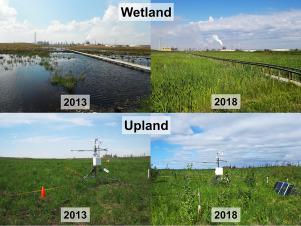
Mine reclamation in the Athabasca oil sands region is legally required as companies must reconstruct disturbed landscapes into functioning ecosystems which previously existed in the Boreal landscape. Upland-wetland systems are relatively new in the constructed landscape and only two exist to date. The objective of this work is to understand the key hydrological changes post-management of a constructed peatland watershed and provide insight on the overall system function. Six years of hydrometric data are presented from the Sandhill Fen Watershed (SFW), a 52-ha upland-wetland catchment built on soft tailings with a pump system to provide fresh water, support drainage, and limit salinization. Wet years (seasonal precipitation > evapotranspiration) occurred in 2013, 2016 and 2018 and dry years (seasonal precipitation < evapotranspiration) occurred in 2014, 2015 and 2017 where wet years had large 5-, 10- and 100-year storms which were absent in dry years. Surface conductance and solar radiation explained most of the variation in ET fluxes. Changes in management practices drove many of the observed hydrological changes. Heavy management in 2013 muted water table (WT) responses to climate as inflow and outflow (via pumps) controlled WT response. After 2014, management efforts declined and hydrological exchanges were predominantly vertical, and saturated storage across the wetland increased. As a result, WT variability was tightly coupled to ET regardless of WT position relative to the ground surface, with greater changes related to deeper water tables, suggesting the absence of water conserving feedback mechanisms. Intra-watershed water movement was primarily towards the wetland from recharge areas in the upland swale, whereas surface runoff was rare and only occurred during extreme rain events and spring snowmelt. Peat properties were degraded compared to those observed in undisturbed peatlands, and natural stratification of the peat profile was absent. Results suggest that current conditions are not favorable for fen-peatland development as marsh-like conditions have developed, limiting water conserving functions and the ability to persist long-term in a changing climate.
中文翻译:
阿萨巴斯卡油砂地区人工泥炭流域的水文功能:潜在轨迹和经验教训
法律要求在阿萨巴斯卡油砂地区进行矿山复垦,因为公司必须将受干扰的景观重建为之前在北方景观中存在的功能生态系统。山地-湿地系统在人工景观中相对较新,迄今为止只有两个。这项工作的目的是了解人工泥炭流域管理后的关键水文变化,并提供整体系统功能的见解。桑德希尔芬流域(SFW)提供了六年的水文数据,该丘陵地带是一块52公顷的高地湿地集水区,建立在软尾矿上,并配有泵系统,以提供淡水,支持排水和限制盐碱化。2013年,2016年和2018年发生湿年(季节降水>蒸散),而干旱年(季节降水<蒸散 蒸发蒸腾)发生在2014年,2015年和2017年,其中潮湿年份有5、10和100年的大型风暴,而干旱年份则没有。表面电导和太阳辐射解释了ET通量的大部分变化。管理实践的变化推动了许多观测到的水文变化。2013年的繁重管理使地下水位(WT)对气候的响应变得无能为力,因为流入和流出(通过泵)控制了WT响应。2014年之后,管理工作减少了,水文交换主要是垂直交换,整个湿地的饱和蓄水量增加了。结果,不管WT相对于地面的位置如何,WT的可变性都与ET紧密相关,与更深的地下水位有关的变化更大,这表明缺乏节水反馈机制。流域内的水流主要是从高地沼泽的补给区流向湿地,而地表径流很少见,仅在极端降雨事件和春季融雪期间发生。与未受扰动的泥炭地相比,泥炭的性能下降,并且泥炭剖面没有自然分层。结果表明,随着沼泽状条件的发展,当前的条件不利于奋斗草原的发展,限制了节水功能和在不断变化的气候中长期维持的能力。并且没有泥炭剖面的自然分层。结果表明,随着沼泽状条件的发展,当前的条件不利于奋斗草原的发展,限制了节水功能和在不断变化的气候中长期维持的能力。并且没有泥炭剖面的自然分层。结果表明,随着沼泽状条件的发展,当前的条件不利于奋斗草原的发展,限制了节水功能和在不断变化的气候中长期维持的能力。


 京公网安备 11010802027423号