当前位置:
X-MOL 学术
›
Geolog. J.
›
论文详情
Our official English website, www.x-mol.net, welcomes your
feedback! (Note: you will need to create a separate account there.)
Assessment of tectonic activity based on the geomorphic indices in the middle reaches of the upstream of Jinsha River, China
Geological Journal ( IF 1.4 ) Pub Date : 2021-04-13 , DOI: 10.1002/gj.4148 Yiqi Ji 1 , Shengrui Su 1, 2 , Zhiheng Liu 1 , Qiangbing Huang 1, 2
Geological Journal ( IF 1.4 ) Pub Date : 2021-04-13 , DOI: 10.1002/gj.4148 Yiqi Ji 1 , Shengrui Su 1, 2 , Zhiheng Liu 1 , Qiangbing Huang 1, 2
Affiliation
|
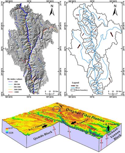
The middle reaches of the upstream of Jinsha River (MRUJR) is located in the eastern segment of the Jinsha River suture zone on the southwest of China. A study of the MRUJR based on tectonic geomorphology is noteworthy for providing a profound understanding of the tectonic transition between the Sichuan-Yunnan and Qamdo blocks and active tectonics in various subbasins. Based on the global digital elevation model Shuttle Radar Topography Mission 1 (30 m resolution) data and geographic information system techniques, four geomorphic indices, the hypsometric integral, stream length-gradient, drainage basin asymmetry, and drainage basin shape were calculated and analysed. Combined with geologic evidence from field surveys and fault slip rates estimated, the tectonic activities and mechanisms were discussed. Through the specific analytical comparisons, the variations in the geomorphic indices were unlikely affected by lithology and climate but showed changes in relevant tectonic activity. The analysis results of geomorphic index value manifested related strong activities in the northwestern and southeastern regions of MRUJR, tilt directions are mainly SW–NE and NE–SW, respectively. The MRUJR is undergoing rapid uplift. These results are consistent with the field evidence.
更新日期:2021-04-13


 京公网安备 11010802027423号