当前位置:
X-MOL 学术
›
Remote Sens. Ecol. Conserv.
›
论文详情
Our official English website, www.x-mol.net, welcomes your
feedback! (Note: you will need to create a separate account there.)
The real potential of current passive satellite data to map aboveground biomass in tropical forests
Remote Sensing in Ecology and Conservation ( IF 3.9 ) Pub Date : 2021-04-08 , DOI: 10.1002/rse2.203 Nidhi Jha 1, 2, 3 , Nitin Kumar Tripathi 1 , Nicolas Barbier 2 , Salvatore G. P. Virdis 1 , Wirong Chanthorn 4 , Gaëlle Viennois 2 , Warren Y. Brockelman 3 , Anuttara Nathalang 3 , Sissades Tongsima 3 , Nophea Sasaki 5 , Raphaël Pélissier 2 , Maxime Réjou‐Méchain 2
Remote Sensing in Ecology and Conservation ( IF 3.9 ) Pub Date : 2021-04-08 , DOI: 10.1002/rse2.203 Nidhi Jha 1, 2, 3 , Nitin Kumar Tripathi 1 , Nicolas Barbier 2 , Salvatore G. P. Virdis 1 , Wirong Chanthorn 4 , Gaëlle Viennois 2 , Warren Y. Brockelman 3 , Anuttara Nathalang 3 , Sissades Tongsima 3 , Nophea Sasaki 5 , Raphaël Pélissier 2 , Maxime Réjou‐Méchain 2
Affiliation
|
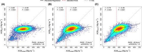
Forest biomass estimation at large scale is challenging and generally entails large uncertainty in tropical regions. With their wall-to-wall coverage ability, passive remote sensing signals are frequently used to extrapolate field estimates of forest aboveground biomass (AGB). However, studies often use limited reference data and/or flawed validation schemes and thus report unreliable extrapolation error estimates. Here, we compared the ability of three medium- to high-resolution passive satellite sensors, Landsat-8 (L8), Sentinel-2B (S2) and Worldview-3 (WV3), to map AGB in a forest landscape of Thailand. We used a large airborne LiDAR-derived AGB dataset as a reference to train and validate a random forest algorithm and conducted robust error assessments and variable selection using spatialized cross-validations. Our results indicate that the selected predictors strongly varied among the three sensors and between analyses restricted to low (≤200 Mg ha−1) and high (>200 Mg ha−1) AGB areas. WV3 and S2 data outperformed L8 data to extrapolate AGB (RMSE of 68 and 72 against 84 Mg ha−1, respectively) due to the inclusion of the red-edge band and, probably, to their higher spatial and spectral resolution. Sensitivity to large AGB values was higher for WV3 than for S2 and L8 with saturation point of 247 Mg ha−1 against 204 and 192 Mg ha−1. AGB values above these saturation points remained poorly predictable, especially for L8, indicating that several tropical forest AGB maps should be interpreted with extreme caution. However, predicted gradients of lower AGB values (≤200 Mg ha−1), i.e., in early forest successional stages, were fairly consistent among sensors (r > 0.70), even if the mean absolute difference between estimates was large when AGB predictions were extrapolated out of the calibration area at regional level (34%). We finally showed that calibrating the model only within the sensitivity AGB domain (e.g., <200 Mg ha−1) minimizes the risk of induced bias for estimating small AGB values. These results provide important benchmarks for interpreting previously published maps and to improve future validation schemes.
中文翻译:

当前被动卫星数据绘制热带森林地上生物量的真正潜力
大规模的森林生物量估计具有挑战性,并且通常在热带地区存在很大的不确定性。凭借其墙到墙的覆盖能力,被动遥感信号经常用于外推森林地上生物量 (AGB) 的实地估计。然而,研究经常使用有限的参考数据和/或有缺陷的验证方案,因此报告不可靠的外推误差估计。在这里,我们比较了三个中高分辨率无源卫星传感器 Landsat-8 (L8)、Sentinel-2B (S2) 和 Worldview-3 (WV3) 在泰国森林景观中绘制 AGB 的能力。我们使用大型机载 LiDAR 衍生的 AGB 数据集作为参考来训练和验证随机森林算法,并使用空间化交叉验证进行稳健的误差评估和变量选择。-1 ) 和高 (>200 Mg ha -1 ) AGB 区域。WV3 和 S2 数据优于 L8 数据以推断 AGB(相对于 84 Mg ha -1 的RMSE 分别为 68 和 72 ),因为包含了红边带,并且可能是因为它们具有更高的空间和光谱分辨率。WV3 对大 AGB 值的敏感性高于 S2 和 L8,饱和点为 247 Mg ha -1,而饱和点为204 和 192 Mg ha -1。高于这些饱和点的 AGB 值仍然很难预测,尤其是对于 L8,这表明应该非常谨慎地解释几个热带森林 AGB 地图。然而,较低 AGB 值(≤200 Mg ha -1),即在早期森林演替阶段,传感器之间相当一致 ( r > 0.70),即使当 AGB 预测从区域级别的校准区域外推时,估计值之间的平均绝对差异很大 (34%)。我们最终表明,仅在灵敏度 AGB 域(例如,<200 Mg ha -1)内校准模型可将估计小 AGB 值时诱发偏差的风险降至最低。这些结果为解释以前发布的地图和改进未来的验证方案提供了重要的基准。
更新日期:2021-04-08
中文翻译:
当前被动卫星数据绘制热带森林地上生物量的真正潜力
大规模的森林生物量估计具有挑战性,并且通常在热带地区存在很大的不确定性。凭借其墙到墙的覆盖能力,被动遥感信号经常用于外推森林地上生物量 (AGB) 的实地估计。然而,研究经常使用有限的参考数据和/或有缺陷的验证方案,因此报告不可靠的外推误差估计。在这里,我们比较了三个中高分辨率无源卫星传感器 Landsat-8 (L8)、Sentinel-2B (S2) 和 Worldview-3 (WV3) 在泰国森林景观中绘制 AGB 的能力。我们使用大型机载 LiDAR 衍生的 AGB 数据集作为参考来训练和验证随机森林算法,并使用空间化交叉验证进行稳健的误差评估和变量选择。-1 ) 和高 (>200 Mg ha -1 ) AGB 区域。WV3 和 S2 数据优于 L8 数据以推断 AGB(相对于 84 Mg ha -1 的RMSE 分别为 68 和 72 ),因为包含了红边带,并且可能是因为它们具有更高的空间和光谱分辨率。WV3 对大 AGB 值的敏感性高于 S2 和 L8,饱和点为 247 Mg ha -1,而饱和点为204 和 192 Mg ha -1。高于这些饱和点的 AGB 值仍然很难预测,尤其是对于 L8,这表明应该非常谨慎地解释几个热带森林 AGB 地图。然而,较低 AGB 值(≤200 Mg ha -1),即在早期森林演替阶段,传感器之间相当一致 ( r > 0.70),即使当 AGB 预测从区域级别的校准区域外推时,估计值之间的平均绝对差异很大 (34%)。我们最终表明,仅在灵敏度 AGB 域(例如,<200 Mg ha -1)内校准模型可将估计小 AGB 值时诱发偏差的风险降至最低。这些结果为解释以前发布的地图和改进未来的验证方案提供了重要的基准。


 京公网安备 11010802027423号