当前位置:
X-MOL 学术
›
Appl. Veg. Sci.
›
论文详情
Our official English website, www.x-mol.net, welcomes your
feedback! (Note: you will need to create a separate account there.)
Mapping structural attributes of tropical dry forests by combining Synthetic Aperture Radar and high‐resolution satellite imagery data
Applied Vegetation Science ( IF 2.0 ) Pub Date : 2021-04-04 , DOI: 10.1111/avsc.12580 Juan Andres‐Mauricio 1 , José René Valdez‐Lazalde 2 , Stephanie P. George‐Chacón 1 , J. Luis Hernández‐Stefanoni 1
Applied Vegetation Science ( IF 2.0 ) Pub Date : 2021-04-04 , DOI: 10.1111/avsc.12580 Juan Andres‐Mauricio 1 , José René Valdez‐Lazalde 2 , Stephanie P. George‐Chacón 1 , J. Luis Hernández‐Stefanoni 1
Affiliation
|
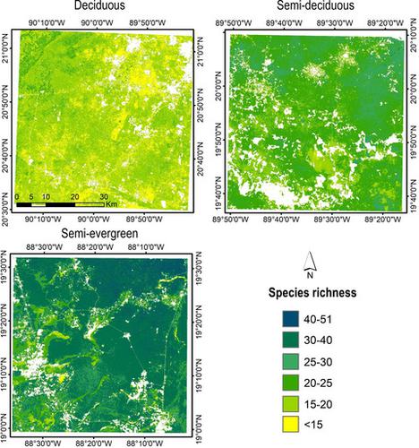
Optical satellite imagery has been used for mapping the spatial distribution of vegetation structure attributes; however, obtaining accurate estimates with optical imagery can be difficult in tropical forests due to their dense canopy and multi‐layered vegetation. Synthetic aperture radar imagery can be more suitable in this case, as the radar signal can penetrate the forest canopy and interact with stems, providing a better estimation of the vegetation structure. This study compared the accuracy of forest species richness, tree diameter, height, and basal area estimates obtained using Sentinel‐2 and Advanced Land Observing Satellite ‐1 (ALOS) Phased Array type L‐band Synthetic Aperture Radar (PALSAR) data, either combined or separately.
中文翻译:

结合合成孔径雷达和高分辨率卫星图像数据绘制热带干旱森林的结构属性
光学卫星图像已用于绘制植被结构属性的空间分布图。但是,由于热带森林茂密的树冠和多层的植被,因此很难用光学图像获得准确的估计值。在这种情况下,合成孔径雷达图像可能更适合,因为雷达信号可以穿透森林冠层并与茎干相互作用,从而可以更好地估算植被结构。这项研究比较了使用Sentinel-2和高级陆地观测卫星-1(ALOS)相控阵类型L波段合成孔径雷达(PALSAR)数据获得的森林物种丰富度,树木直径,高度和基础面积估计值的准确性,或分开。
更新日期:2021-04-29
中文翻译:
结合合成孔径雷达和高分辨率卫星图像数据绘制热带干旱森林的结构属性
光学卫星图像已用于绘制植被结构属性的空间分布图。但是,由于热带森林茂密的树冠和多层的植被,因此很难用光学图像获得准确的估计值。在这种情况下,合成孔径雷达图像可能更适合,因为雷达信号可以穿透森林冠层并与茎干相互作用,从而可以更好地估算植被结构。这项研究比较了使用Sentinel-2和高级陆地观测卫星-1(ALOS)相控阵类型L波段合成孔径雷达(PALSAR)数据获得的森林物种丰富度,树木直径,高度和基础面积估计值的准确性,或分开。


 京公网安备 11010802027423号