Ocean & Coastal Management ( IF 4.8 ) Pub Date : 2021-04-01 , DOI: 10.1016/j.ocecoaman.2021.105632 Naheem Adebisi , Abdul-Lateef Balogun , Teh Hee Min , Abdulwaheed Tella
|
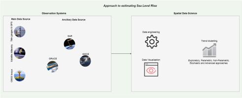
Significant developments have been made in the observation systems and techniques of estimating sea level towards meeting the standard accuracy requirement of Global Climate Observation Systems (GCOS). This study undertakes a systematic review of the current advances in estimating sea level change in the context of the 4th industrial revolution. Trends in the use of main observation systems such as tide gauges, satellite altimetry, and ancillary systems such as GNSS and Autonomous Surface Vehicles were explored. Crucially, we examined the contribution of dedicated waveform retracking strategies, advanced corrections and radar technology such as Ka-band altimetry of SARAL/Altika and SAR mode innovations to the progress in coastal altimetry. Further, we show the role of emerging spatial data science concepts and processing workflows in sea level study. Findings suggest that in-situ sea level observation through tide gauges remains the best approach for long-term coastal sea level study despite its limitations while satellite altimetry is suitable for contemporary global and regional scales. Detailed understating of global, regional and local mean sea level change will require an augmentation of tide gauge, satellite altimetry and other ancillary remote sensing and in situ systems. Densification of tide gauges and co-located GNSS networks at sparsely covered regions and improvement in precision of satellite altimetry data for coastal use are also essential for a fully integrated sea level observation system. From the analysis of over 30 trend models that span exploratory, parametric, non-parametric, stochastic and advanced classes in the literature, we conclude that the best model is the one with good statistical foundation and similar assumption with the sea level pattern.
中文翻译:
估计海平面上升的进展:潮汐仪,卫星测高仪和空间数据科学方法的回顾
为了满足全球气候观测系统(GCOS)的标准精度要求,观测系统和海平面估算技术已经取得了重大进展。这项研究对第四次工业革命背景下海平面变化的最新估计进行了系统的回顾。探索了主要观测系统(如潮汐仪,卫星测高仪)以及辅助系统(如GNSS和自动水面飞行器)的使用趋势。至关重要的是,我们研究了专用波形跟踪策略,先进的校正技术和雷达技术(如SARAL / Altika的Ka波段测高仪)和SAR模式创新对沿海测高仪发展的贡献。进一步,我们展示了新兴的空间数据科学概念和处理工作流程在海平面研究中的作用。研究结果表明,尽管有其局限性,但通过潮汐仪进行的原位海平面观测仍然是长期沿海海平面研究的最佳方法,而卫星测高法则适用于当代的全球和区域尺度。全球,区域和地方平均海平面变化的详细低估将需要增加潮汐仪,卫星测高仪和其他辅助遥感及原位系统。对于完全集成的海平面观测系统来说,在稀疏覆盖区域的潮汐仪和位于同一地点的GNSS网络的致密化以及卫星测高仪数据在沿海地区的使用精度的提高也是必不可少的。通过对超过30种趋势模型的分析,这些模型涵盖了探索性,参数性,


 京公网安备 11010802027423号