当前位置:
X-MOL 学术
›
Earth Surf.Process. Land.
›
论文详情
Our official English website, www.x-mol.net, welcomes your
feedback! (Note: you will need to create a separate account there.)
Mega-scale glacial lineations formed by ice shelf grounding in the Canadian Beaufort Sea during multiple glaciations
Earth Surface Processes and Landforms ( IF 2.8 ) Pub Date : 2021-03-31 , DOI: 10.1002/esp.5125 Michael Riedel 1 , Scott Dallimore 2 , Michael Wamsteeker 3 , Gary Taylor 4 , Edward L. King 5 , Kristin M. M. Rohr 2 , Jong Kuk Hong 6 , Young Keun Jin 6
Earth Surface Processes and Landforms ( IF 2.8 ) Pub Date : 2021-03-31 , DOI: 10.1002/esp.5125 Michael Riedel 1 , Scott Dallimore 2 , Michael Wamsteeker 3 , Gary Taylor 4 , Edward L. King 5 , Kristin M. M. Rohr 2 , Jong Kuk Hong 6 , Young Keun Jin 6
Affiliation
|
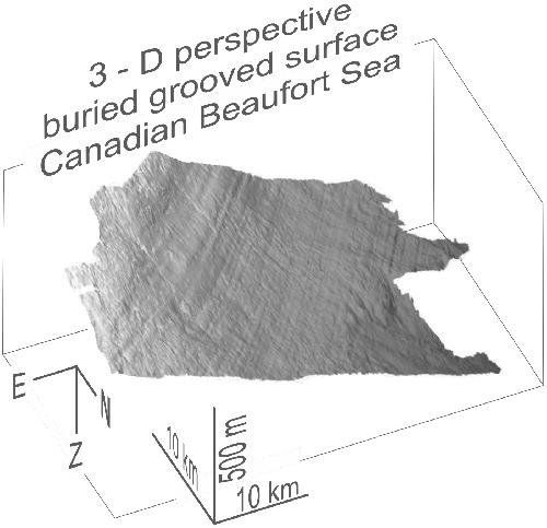
Mega-scale glacial lineations formed by the raking of ice shelves across the seafloor have been reported from multiple polar regions. Here, we present the first evidence of continental slope situated buried lineations in the southern Canadian Beaufort Sea in present-day water depths of 220 to 800 m. Three separate surfaces with lineations are defined at sub-seafloor depths of 40 m to 390 m. All lineations are mostly parallel to the general trend of slope contours. The uppermost surface is recognized over a distance of 56 km. In water depths > 500 m the lineations are parallel to each other at a consistent direction (43°–44°). The second lineated surface is a regionally occurring erosional unconformity. This event has two sub-sets of lineations: mid-slope situated lineations oriented at 42°–48°, and lineations closer to the continental shelf break at 55°–59°. The third lineated surface is an unconformable horizon buried up to 390 m below seafloor with lineaments oriented between 30° and 55°. All three sets of lineations are interpreted to have been produced by ice-ploughing on the paleo-seafloor through the grounding of an ice shelf. Our observations are similar to those documented along the slope off northern Alaska, Chukchi Rise, and Lomonosov Ridge. Collectively, these observations support the concept of an extensive ice shelf across the Arctic Ocean that grounded locally along its margins during multiple glaciations, including during the penultimate (or an earlier) glaciation. The youngest set of lineations indicates ice movement to the southwest with a suggested source in Amundsen Gulf and/or M'Clure Strait. Tentative age considerations for these youngest lineations indicate the first evidence for an analogous extensive ice shelf configuration for the Last Glacial Maximum.
中文翻译:

加拿大波弗特海冰架在多次冰川作用期间接地形成的巨型冰川线
已有多个极地地区报告了由横跨海底的冰架倾斜形成的巨型冰川线。在这里,我们提出了大陆坡位于加拿大波弗特海南部现今水深 220 至 800 m 的埋藏线的第一个证据。在 40 m 至 390 m 的海底深度处定义了三个带有划线的独立表面。所有线形大多平行于坡度等值线的总趋势。最上面的表面在 56 公里的距离内被识别。在水深 > 500 m 中,线以一致的方向相互平行(43°–44°)。第二个线状表面是区域性发生的侵蚀不整合面。该事件有两个子集线状体:位于 42°–48° 的中坡定位线状体,更靠近大陆架的线在 55°–59°断裂。第三条线状表面是埋藏在海底以下 390 m 处的不整合地层,线状线的方向介于 30° 和 55° 之间。所有三组线都被解释为通过冰架的接地在古海底进行冰犁而产生的。我们的观察结果与阿拉斯加北部、楚科奇隆起和罗蒙诺索夫海岭附近斜坡上记录的观察结果相似。总的来说,这些观察结果支持横跨北冰洋的广泛冰架的概念,在多次冰期期间,包括在倒数第二次(或更早)冰期期间,沿其边缘局部搁浅。最年轻的一组线表明冰向西南移动,建议来源位于阿蒙森湾和/或 M'Clure 海峡。
更新日期:2021-03-31
中文翻译:
加拿大波弗特海冰架在多次冰川作用期间接地形成的巨型冰川线
已有多个极地地区报告了由横跨海底的冰架倾斜形成的巨型冰川线。在这里,我们提出了大陆坡位于加拿大波弗特海南部现今水深 220 至 800 m 的埋藏线的第一个证据。在 40 m 至 390 m 的海底深度处定义了三个带有划线的独立表面。所有线形大多平行于坡度等值线的总趋势。最上面的表面在 56 公里的距离内被识别。在水深 > 500 m 中,线以一致的方向相互平行(43°–44°)。第二个线状表面是区域性发生的侵蚀不整合面。该事件有两个子集线状体:位于 42°–48° 的中坡定位线状体,更靠近大陆架的线在 55°–59°断裂。第三条线状表面是埋藏在海底以下 390 m 处的不整合地层,线状线的方向介于 30° 和 55° 之间。所有三组线都被解释为通过冰架的接地在古海底进行冰犁而产生的。我们的观察结果与阿拉斯加北部、楚科奇隆起和罗蒙诺索夫海岭附近斜坡上记录的观察结果相似。总的来说,这些观察结果支持横跨北冰洋的广泛冰架的概念,在多次冰期期间,包括在倒数第二次(或更早)冰期期间,沿其边缘局部搁浅。最年轻的一组线表明冰向西南移动,建议来源位于阿蒙森湾和/或 M'Clure 海峡。


 京公网安备 11010802027423号