当前位置:
X-MOL 学术
›
Hydrol. Process.
›
论文详情
Our official English website, www.x-mol.net, welcomes your
feedback! (Note: you will need to create a separate account there.)
Investigating sea‐state effects on flash flood hydrograph and inundation forecasting
Hydrological Processes ( IF 2.8 ) Pub Date : 2021-03-29 , DOI: 10.1002/hyp.14151 George Papaioannou 1 , George Varlas 1 , Anastasios Papadopoulos 1 , Athanasios Loukas 2 , Petros Katsafados 3 , Elias Dimitriou 1
Hydrological Processes ( IF 2.8 ) Pub Date : 2021-03-29 , DOI: 10.1002/hyp.14151 George Papaioannou 1 , George Varlas 1 , Anastasios Papadopoulos 1 , Athanasios Loukas 2 , Petros Katsafados 3 , Elias Dimitriou 1
Affiliation
|
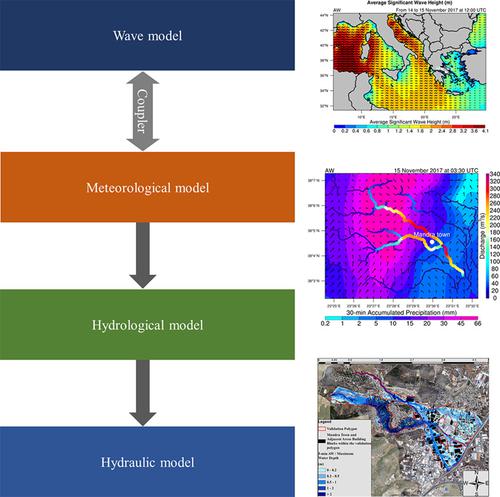
A common source of uncertainty in flood inundation forecasting is the hydrograph used. Given the role of sea‐air‐hydro‐land chain processes on the water cycle, flood hydrographs in coastal areas can be indirectly affected by sea state. This study investigates sea‐state effects on precipitation, discharge, and flood inundation forecasting implementing atmospheric, ocean wave, hydrological, and hydraulic‐hydrodynamic coupled models. The Chemical Hydrological Atmospheric Ocean wave System (CHAOS) was used for coupled hydro‐meteorological‐wave simulations ‘accounting’ or ‘not accounting’ the impact of sea state on precipitation and, subsequently, on flood hydrograph. CHAOS includes the WRF‐Hydro hydrological model and the WRF‐ARW meteorological model two‐way coupled with the WAM wave model through the OASIS3‐MCT coupler. Subsequently, the 2D HEC‐RAS hydraulic‐hydrodynamic model was forced by the flood hydrographs and map the inundated areas. A flash flood event occurred on 15 November 2017 in Mandra, Attica, Greece, causing 24 fatalities, and damages was selected as case study. The calibration of models was performed exploiting historical flood records and previous studies. Human interventions such as hydraulic works and the urban areas were included in the hydraulic modelling geometry domain. The representation of the resistance caused by buildings was based on Unmanned Aerial System (UAS) data while the local elevation rise method was used in the urban‐flood simulation. The flood extent results were assessed using the Critical Success Index (CSI), and CSI penalize. Integrating sea‐state affected the forecast of precipitation and discharge peaks, causing up to +24% and from −8% to +36% differences, respectively, improving inundation forecast by 4.5% and flooding additional approximately 70 building blocks. The precipitation forcing time step was also highlighted as significant factor in such a small‐scale flash flood. The integrated multidisciplinary methodological approach could be adopted in operational forecasting for civil protection applications facilitating the protection of socio‐economic activities and human lives during similar future events.
中文翻译:

研究海况对山洪洪水水位的影响和淹没预报
洪水淹没预报的不确定性的一个常见来源是所使用的水位图。考虑到海空水陆链过程在水循环中的作用,沿海地区的洪水水位图可能会间接受到海况的影响。这项研究调查了大气状态对降水,流量和洪水淹没的影响,并通过大气,海浪,水文和水力-水动力耦合模型进行了预测。化学水文大气海浪系统(CHAOS)用于水文-气象-波耦合模拟,以“解释”或“不考虑”海况对降水的影响,以及随后对洪水水位的影响。CHAOS包括通过OASIS3-MCT耦合器与WM波模型双向耦合的WRF-Hydro水文模型和WRF-ARW气象模型。随后,2D HEC-RAS水力-水动力模型是由洪水水文图强迫绘制的,并绘制了淹没区域的地图。2017年11月15日在希腊阿提卡的曼德拉发生了一次山洪暴发事件,造成24人死亡,并选择了损失作为案例研究。利用历史洪水记录和先前的研究对模型进行了校准。水力模型几何领域中包括水力工程和市区等人为干预。建筑物引起的阻力的表示基于无人机系统(UAS)数据,而局部高程上升方法则用于城市洪水模拟中。使用“关键成功指数”(CSI)和CSI惩罚评估洪水程度结果。不断整合的海洋状况影响了降水量和排放量峰值的预测,造成分别高达+ 24%和-8%至+ 36%的差异,使洪水预报提高4.5%,并淹没了大约70个构建基块。在这样的小规模山洪暴发中,降水强迫时间步长也被认为是重要的因素。可以将综合的多学科方法学方法用于民防应用的业务预测中,以促进在类似未来事件中保护社会经济活动和人类生活。
更新日期:2021-04-19
中文翻译:
研究海况对山洪洪水水位的影响和淹没预报
洪水淹没预报的不确定性的一个常见来源是所使用的水位图。考虑到海空水陆链过程在水循环中的作用,沿海地区的洪水水位图可能会间接受到海况的影响。这项研究调查了大气状态对降水,流量和洪水淹没的影响,并通过大气,海浪,水文和水力-水动力耦合模型进行了预测。化学水文大气海浪系统(CHAOS)用于水文-气象-波耦合模拟,以“解释”或“不考虑”海况对降水的影响,以及随后对洪水水位的影响。CHAOS包括通过OASIS3-MCT耦合器与WM波模型双向耦合的WRF-Hydro水文模型和WRF-ARW气象模型。随后,2D HEC-RAS水力-水动力模型是由洪水水文图强迫绘制的,并绘制了淹没区域的地图。2017年11月15日在希腊阿提卡的曼德拉发生了一次山洪暴发事件,造成24人死亡,并选择了损失作为案例研究。利用历史洪水记录和先前的研究对模型进行了校准。水力模型几何领域中包括水力工程和市区等人为干预。建筑物引起的阻力的表示基于无人机系统(UAS)数据,而局部高程上升方法则用于城市洪水模拟中。使用“关键成功指数”(CSI)和CSI惩罚评估洪水程度结果。不断整合的海洋状况影响了降水量和排放量峰值的预测,造成分别高达+ 24%和-8%至+ 36%的差异,使洪水预报提高4.5%,并淹没了大约70个构建基块。在这样的小规模山洪暴发中,降水强迫时间步长也被认为是重要的因素。可以将综合的多学科方法学方法用于民防应用的业务预测中,以促进在类似未来事件中保护社会经济活动和人类生活。


 京公网安备 11010802027423号