Gondwana Research ( IF 7.2 ) Pub Date : 2021-03-29 , DOI: 10.1016/j.gr.2021.03.008 A. Vasanthi , M. Santosh
|
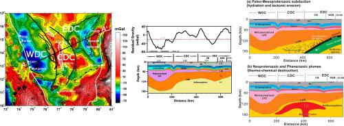
The construction and destruction of continents, cratons and supercontinents on the globe involved multiple events of plume, rifting, subduction-accretion, and collision through the long history of evolution of our planet. Archean cratons preserve the records of continent building in the Early Earth and understanding their lithospheric architecture is fundamental to building geodynamic models. The Dharwar craton in southern India is among the major cratons on the globe. Recent geological and geochronological studies indicate that the craton formed through the assembly of a number of micro-blocks, although the terrane boundaries and lithospheric structure have not been well-defined. Here, we analyze satellite gravity data, covering the entire Dharwar craton and its surrounding regions, with a view to understand the regional lithospheric architecture and the geodynamic evolution. Our results on the residual gravity field, based on finite element approach, can clearly demarcate the boundaries of the major geotectonic units in the Dharwar craton and surrounding regions. We identify the presence of a conspicuous residual gravity low (−55 mGal) that runs north–south for about 700 km, paralleling the western margin of the Dharwar craton. This gravity low passes through the Chitradurga schist belt and covers the Koyna seismogenic region in the north to Coimbatore in the south. The gravity patterns observed over this region, might suggest a deep-seated paleo- rift zone, which we term as ‘Koyna-Coimbatore rift’. The prominent gravity low associated with this rift structure, can be explained by the presence of a 70 km thick low velocity/low density zone (LVZ) in subcrustal lithospheric mantle, suggesting asthenospheric flow into the upper mantle. The Western Dharwar Craton (WDC) might extend further north encompassing the Koyna-Warna seismic zone. Another major finding from this study is delineation of the Central Dharwar Cratonic (CDC) block between the Chitradurga shear zone and the Kolar greenstone belt, which is characterized by a prominent residual gravity high zone (+20 mGal), coinciding with the exposures of the Closepet granitoids and their equivalents, possibly marking a collisional suture between two microblocks. The 2½D residual gravity modeling across an E-W profile, which cuts all the major geotectonic features of WDC, CDC and Eastern Dharwar Craton (EDC), reveals popping-up of the CDC terrane, below which Moho has upwarped to a depth of 36 km and the lithosphere is considerably thinner at about 120 km, compared to 48 km and 175 km respectively in the WDC. This feature corresponds to lithospheric destruction of almost 100–120 km below the Dharwar craton, with magma underplating. On the eastern side of the craton, the positive residual gravity contours that correspond to the Eastern Ghats Belt rocks, take a sharp turn into the adjacent offshore region northeast of Ongole, and continue further south, until the granulite terrane north of Chennai, indicating the absence of the Eastern Ghats Belt rocks east of Cuddapah Basin. Our gravity model is able to demarcate three collisional boundaries between (i) WDC and CDC, (ii) CDC and Cuddapah Basin, and (iii) Nellore Schist Belt and adjoining east coast terrane. The extensive lithospheric destruction with removal of nearly 100 km of the cratonic root is correlated to prolonged subduction during Paleo-Neoproterozoic, together with mantle plumes at different times playing a subordinate role, thus indicating combined mechanical, thermal and chemical erosion.
中文翻译:
太古代达尔文克拉通及其周围地层的岩石圈结构和地球动力学:来自卫星重力研究的新见解
在地球的漫长发展历史中,地球上各大洲,克拉通和超大陆的建设和破坏涉及羽流,裂谷,俯冲增生和碰撞等多种事件。太古代克拉通保存了早期地球大陆构造的记录,并且了解它们的岩石圈构造是建立地球动力学模型的基础。印度南部的Dharwar克拉通是全球主要克拉通之一。最近的地质和年代学研究表明,克拉通是通过组装许多微块而形成的,尽管地界和岩石圈结构尚未得到明确定义。在这里,我们分析了卫星重力数据,涵盖了整个Dharwar克拉通及其周围地区,以了解区域岩石圈构造和地球动力学演化。我们基于有限元方法在残余重力场上得到的结果可以清楚地划分出Dharwar克拉通及其周围地区主要大地构造单元的边界。我们确定存在一个明显的残余重力低点(−55 mGal),该重力北下向南延伸约700 km,与Dharwar克拉通的西边缘平行。该重力低点穿过Chitradurga片岩带,覆盖了北部的科伊纳地震发生区和南部的哥印拜陀。在该区域观察到的重力模式可能暗示着一个深层的古裂谷带,我们称其为“科伊纳-哥印拜陀裂谷”。与该裂谷结构有关的引力低点 可以解释为在地壳下岩石圈地幔中存在一个70 km厚的低速/低密度带(LVZ),这表明软流圈流入上地幔。西部Dharwar Craton(WDC)可能会进一步向北延伸,包括Koyna-Warna地震带。这项研究的另一个主要发现是在Chitradurga剪切带和Kolar绿岩带之间划定了中部Dharwar Cratonic(CDC)区块,该区块的特征是突出的残余重力高区(+20 mGal),与高辐射带的暴露量相吻合。壁毯花岗石及其等同物,可能标志着两个微块之间的碰撞缝合线。整个EW剖面的2½D残余重力模型都将切割WDC,CDC和Eastern Dharwar Craton(EDC)的所有主要构造特征,揭示出CDC地貌的弹出,在此之下,莫霍面上升到36公里的深度,而岩石圈则更薄,约120公里,而WDC分别为48公里和175公里。此特征对应于Dharwar克拉通以下近100-120 km的岩石圈破坏,并有岩浆作用。在克拉通的东侧,与东高止山脉带岩石相对应的正残余重力等高线,急速转弯进入Ongole东北部的相邻近海区域,并继续向南延伸,直到金奈以北的粒状花岗岩地层,表明瓜达帕盆地以东没有东高止山脉带岩石。我们的重力模型能够划定(i)WDC和CDC,(ii)CDC和Cuddapah盆地以及(iii)Nellore Schist带和毗邻的东海岸地带之间的三个碰撞边界。


 京公网安备 11010802027423号