当前位置:
X-MOL 学术
›
Earth Surf.Process. Land.
›
论文详情
Our official English website, www.x-mol.net, welcomes your
feedback! (Note: you will need to create a separate account there.)
A GIS focal approach for characterizing gully geometry
Earth Surface Processes and Landforms ( IF 2.8 ) Pub Date : 2021-03-29 , DOI: 10.1002/esp.5122 Carlos Castillo 1 , Henrique G. Momm 2 , Robert R. Wells 3 , Ronald L. Bingner 3 , Rafael Pérez 1
Earth Surface Processes and Landforms ( IF 2.8 ) Pub Date : 2021-03-29 , DOI: 10.1002/esp.5122 Carlos Castillo 1 , Henrique G. Momm 2 , Robert R. Wells 3 , Ronald L. Bingner 3 , Rafael Pérez 1
Affiliation
|
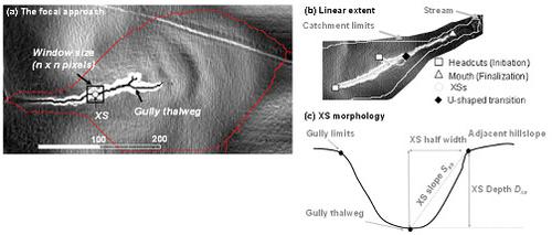
In this work we examined the explanatory factors of gully geometry in the Campiña landscape in southern Spain using a geographic information system (GIS) focal approach with regional topographic products (1.5 m LiDAR [light detecton and ranging] digital elevation model [DEM] for elevation data and 0.5 m orthophotography for gully limit delineation). We evaluated the performance of a focal approach (based on neighbourhood calculations) using topographic factors for characterizing the gully linear extent and cross-section (XS) morphology (i.e., depth, D, width, W, mean slope, S and width-to-depth ratio, WDR). As for the longitudinal analysis, focal variables (e.g., using the 11 × 11 mean thalweg slope and 75-m downstream mean slope) outperformed the pixel-based approach, with accurate spatial predictions for gully headcuts and mouth locations. The threshold between gullied and non-gullied areas in a slope-area diagram took the form of a break-line rather than a straight limit. For estimating the main XS dimensions (D and W), the Half-width method was applied by selecting the closest point to the thalweg at the gully limits. The tendency to underestimate XS depths was corrected by applying the equations derived from an assessment of the sampling errors in DEMs datasets. The 50 m adjacent slope to the gully was the best explanatory descriptor of both XS dimensions (due to energetic and geometric reasons) along with the channel density, drainage area and total gully length. The XS mean slope and WDR were controlled by the resistance of the materials (investigated through geotechnical and vane-test surveys) where incision processes were dominant (V-shaped XSs in upstream and middle reaches). As sedimentation started to become significant, both morphological parameters changed abruptly and XSs tended to show a trapezoid shape. An adaptative focal strategy with varying window sizes produced better results than the pixel-based approach, requiring larger calculation scopes in areas of greater DEM uncertainty.
中文翻译:

表征沟谷几何形状的 GIS 焦点方法
在这项工作中,我们使用地理信息系统 (GIS) 焦点方法和区域地形产品(1.5 m LiDAR [光检测和测距] 数字高程模型 [DEM] 用于高程)检查了西班牙南部坎皮纳景观中沟渠几何的解释因素数据和 0.5 m 正射影像用于刻划沟壑界限)。我们使用用于表征沟渠线性范围和横截面 (XS) 形态(即深度、D、宽度、W、平均坡度、S)的地形因素来评估聚焦方法(基于邻域计算)的性能和宽深比,WDR)。至于纵向分析,焦点变量(例如,使用 11 × 11 平均 thalweg 坡度和 75 米下游平均坡度)优于基于像素的方法,对沟壑断头和嘴部位置进行准确的空间预测。坡度面积图中沟壑区和非沟壑区之间的阈值采用折断线的形式,而不是直线限制。用于估计主要的 XS 尺寸(D和W),半角法是通过选择最接近沟谷界限处的 thalweg 的点来应用的。低估 XS 深度的趋势通过应用从 DEM 数据集中采样误差评估得出的方程得到纠正。与沟渠相邻的 50 m 坡度是 XS 维度(由于能量和几何原因)以及渠道密度、流域面积和沟渠总长度的最佳解释性描述符。XS 平均坡度和 WDR 由材料的阻力控制(通过岩土工程和叶片测试调查进行调查),其中切割过程占主导地位(上游和中游的 V 形 XS)。随着沉积开始变得显着,两种形态参数都发生了突然变化,XSs 趋于呈现梯形形状。
更新日期:2021-03-29
中文翻译:
表征沟谷几何形状的 GIS 焦点方法
在这项工作中,我们使用地理信息系统 (GIS) 焦点方法和区域地形产品(1.5 m LiDAR [光检测和测距] 数字高程模型 [DEM] 用于高程)检查了西班牙南部坎皮纳景观中沟渠几何的解释因素数据和 0.5 m 正射影像用于刻划沟壑界限)。我们使用用于表征沟渠线性范围和横截面 (XS) 形态(即深度、D、宽度、W、平均坡度、S)的地形因素来评估聚焦方法(基于邻域计算)的性能和宽深比,WDR)。至于纵向分析,焦点变量(例如,使用 11 × 11 平均 thalweg 坡度和 75 米下游平均坡度)优于基于像素的方法,对沟壑断头和嘴部位置进行准确的空间预测。坡度面积图中沟壑区和非沟壑区之间的阈值采用折断线的形式,而不是直线限制。用于估计主要的 XS 尺寸(D和W),半角法是通过选择最接近沟谷界限处的 thalweg 的点来应用的。低估 XS 深度的趋势通过应用从 DEM 数据集中采样误差评估得出的方程得到纠正。与沟渠相邻的 50 m 坡度是 XS 维度(由于能量和几何原因)以及渠道密度、流域面积和沟渠总长度的最佳解释性描述符。XS 平均坡度和 WDR 由材料的阻力控制(通过岩土工程和叶片测试调查进行调查),其中切割过程占主导地位(上游和中游的 V 形 XS)。随着沉积开始变得显着,两种形态参数都发生了突然变化,XSs 趋于呈现梯形形状。


 京公网安备 11010802027423号