Computers & Geosciences ( IF 4.4 ) Pub Date : 2021-03-25 , DOI: 10.1016/j.cageo.2021.104724 Amin Aghaee , Pejman Shamsipour , Shawn Hood , Rasmus Haugaard
|
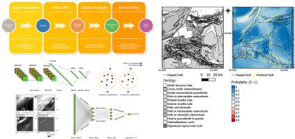
In this paper we present the framework and open-source software code to train and apply Deep Learning Convolutional Neural Networks (CNNs) to the prediction of geological lineaments using topographic, magnetic, and gravity raster data. Many important applications relate to the recognition of linear geological structures from remote sensing data, such as thrust faults, bedrock fault and shear zones, lithological contacts, fractures and fold structures. The digitization of fault lineaments is conventionally performed by geologists or geophysicists with working knowledge of the relevant data, e.g., topographic Digital Elevation Model, magnetic data, and gravity data. Visual inspection and extraction is simple but subjective; the process is also time-expensive with efficiency and accuracy depending on the individual's knowledge, experience, and skill. For decades there has been interest in ways to automate this process. Our CNN approach is trained using publicly available lineament GIS data from the Quest BC project in British Columbia, Canada, and the Loch Lilly-Kars area of New South Wales, Australia. The datasets used to train the prediction models resulted in interesting predictions proximal to the training areas: some major lineaments are indicated, some are missed, and potential new (valid) lineaments are indicated. The results indicate potential for use as a semi-automated lineament detection solution. In contrast, but as anticipated, application of the model to the blind-test area of the Swayze greenstone belt, Ontario, produced poor lineament prediction results (as compared to publicly available interpretations). We interpret this result as related to insufficiently large training data inputs. However, it is inferred that results could be improved through feature engineering (e.g., use of topographic slope, rather than simply elevation) without the need to simply create larger training datasets. We hope that, by making the code open-source, the geoscience community will use this platform to gradually improve an open source fault prediction model.
中文翻译:
卷积神经网络使用概率聚类进行遥感数据的半自动线性检测和矢量化:一种方法和一个挑战
在本文中,我们提供了框架和开源软件代码,以训练和应用深度学习卷积神经网络(CNN)来使用地形,磁和重力栅格数据预测地质构造。许多重要的应用涉及从遥感数据中识别线性地质结构,例如逆冲断层,基岩断层和剪切带,岩性接触,裂缝和褶皱结构。断层构造的数字化通常由地质学家或地球物理学家在具有相关数据(例如地形数字高程模型,磁数据和重力数据)的工作知识的情况下进行。外观检查和提取很简单,但主观;根据个人的知识,经验,和技巧。几十年来,人们一直对自动执行此过程的方法感兴趣。我们的CNN方法使用来自加拿大不列颠哥伦比亚省的Quest BC项目以及澳大利亚新南威尔士州的Loch Lilly-Kars地区的公开可用lineament GIS数据进行训练。用于训练预测模型的数据集在训练区域附近产生了有趣的预测:指示了一些主要谱系,有些遗漏了,并指出了潜在的新(有效)谱系。结果表明有潜力用作半自动谱系检测解决方案。相反,但正如预期的那样,将该模型应用到安大略省Swayze绿岩带的盲区测试中,产生了较差的线性预测结果(与可公开获得的解释相比)。我们认为此结果与训练数据输入不足有关。但是,可以推断,可以通过特征工程(例如,使用地形坡度,而不是简单地使用高程)来改善结果,而无需简单地创建较大的训练数据集。我们希望,通过使代码开源,地球科学界将使用该平台逐步改进开源故障预测模型。


 京公网安备 11010802027423号