Our official English website, www.x-mol.net, welcomes your
feedback! (Note: you will need to create a separate account there.)
City planning and floods: The strategy of Montpellier
The Geographical Journal ( IF 3.6 ) Pub Date : 2021-03-18 , DOI: 10.1111/geoj.12387 Alexandre Brun 1 , Jean‐Paul Volle 1
The Geographical Journal ( IF 3.6 ) Pub Date : 2021-03-18 , DOI: 10.1111/geoj.12387 Alexandre Brun 1 , Jean‐Paul Volle 1
Affiliation
|
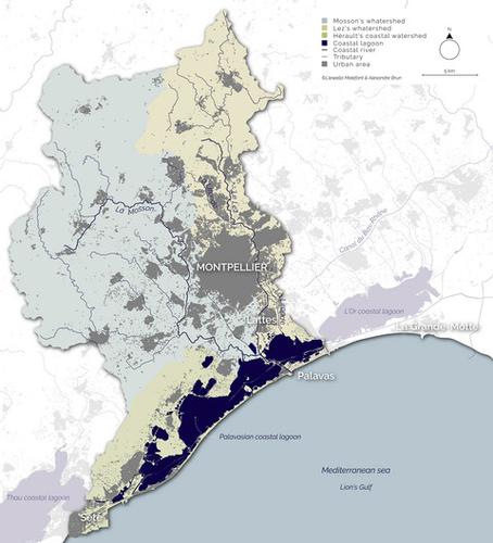
Located between Marseille and Barcelona, Montpellier is one of the most attractive cities of the Mediterranean coast. It has more than 460,000 inhabitants and grows by 7,500 more inhabitants every year. This is largely due to its positive image and its freshly constructed neighbourhoods “Antigone” and “Port-Marianne.” From the late 1970s, the municipality’s strategy was to organise the urban sprawl to the east and then towards the sea in the south of the city. The Lez, a small coastal river, well known for its spectacular flash floods, was the spine of this new urban growth. Internationally renowned architects and planners have been recruited to build these new “green” neighbourhoods (in French “éco-quartiers”) located on lands that used to be flooded regularly. This urban policy is largely due to the Montpellier’s former mayor Georges Frêche and his deputy, the geographer Raymond Dugrand. The “urban planning” concept, or “urban design” projects, have largely been used by the local experts and officials to describe this development, but seem to be misused in this case. It has being mostly a political city-project, still having the same objective as more than 30 years ago: to turn Montpellier towards the seaside. This paper will return to the strategy used at that time and, in retrospect, all the interrogations that have followed in terms of sustainable development and flood risk management.
中文翻译:

城市规划与洪水:蒙彼利埃的战略
蒙彼利埃位于马赛和巴塞罗那之间,是地中海沿岸最具吸引力的城市之一。它拥有超过 460,000 名居民,每年增加 7,500 名居民。这主要是由于其积极的形象和新建的街区“安提戈涅”和“玛丽安港”。从 1970 年代后期开始,该市的战略是组织城市向东扩张,然后向城市南部的大海扩张。Lez 是一条沿海小河,以其壮观的山洪而闻名,是这一新城市发展的支柱。已聘请国际知名建筑师和规划师在过去经常被洪水淹没的土地上建造这些新的“绿色”社区(法国“生态区”)。这一城市政策主要归功于蒙彼利埃的前市长 Georges Frêche 和他的副手、地理学家 Raymond Dugrand。“城市规划”概念,或“城市设计”项目,在很大程度上被当地专家和官员用来描述这一发展,但在这种情况下似乎被滥用了。它主要是一个政治城市项目,仍然具有与 30 多年前相同的目标:将蒙彼利埃转向海边。本文将回到当时使用的策略,并回顾在可持续发展和洪水风险管理方面的所有质疑。但在这种情况下似乎被滥用了。它主要是一个政治城市项目,仍然具有与 30 多年前相同的目标:将蒙彼利埃转向海边。本文将回到当时使用的策略,并回顾在可持续发展和洪水风险管理方面的所有质疑。但在这种情况下似乎被滥用了。它主要是一个政治城市项目,仍然具有与 30 多年前相同的目标:将蒙彼利埃转向海边。本文将回到当时使用的策略,并回顾在可持续发展和洪水风险管理方面的所有质疑。
更新日期:2021-03-18
中文翻译:
城市规划与洪水:蒙彼利埃的战略
蒙彼利埃位于马赛和巴塞罗那之间,是地中海沿岸最具吸引力的城市之一。它拥有超过 460,000 名居民,每年增加 7,500 名居民。这主要是由于其积极的形象和新建的街区“安提戈涅”和“玛丽安港”。从 1970 年代后期开始,该市的战略是组织城市向东扩张,然后向城市南部的大海扩张。Lez 是一条沿海小河,以其壮观的山洪而闻名,是这一新城市发展的支柱。已聘请国际知名建筑师和规划师在过去经常被洪水淹没的土地上建造这些新的“绿色”社区(法国“生态区”)。这一城市政策主要归功于蒙彼利埃的前市长 Georges Frêche 和他的副手、地理学家 Raymond Dugrand。“城市规划”概念,或“城市设计”项目,在很大程度上被当地专家和官员用来描述这一发展,但在这种情况下似乎被滥用了。它主要是一个政治城市项目,仍然具有与 30 多年前相同的目标:将蒙彼利埃转向海边。本文将回到当时使用的策略,并回顾在可持续发展和洪水风险管理方面的所有质疑。但在这种情况下似乎被滥用了。它主要是一个政治城市项目,仍然具有与 30 多年前相同的目标:将蒙彼利埃转向海边。本文将回到当时使用的策略,并回顾在可持续发展和洪水风险管理方面的所有质疑。但在这种情况下似乎被滥用了。它主要是一个政治城市项目,仍然具有与 30 多年前相同的目标:将蒙彼利埃转向海边。本文将回到当时使用的策略,并回顾在可持续发展和洪水风险管理方面的所有质疑。


 京公网安备 11010802027423号