Geomorphology ( IF 3.1 ) Pub Date : 2021-03-18 , DOI: 10.1016/j.geomorph.2021.107696 Sunando Bandyopadhyay , Sayantan Das , Nabendu Sekhar Kar
|
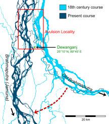
Avulsions involve switching of fluvial discharge through a new channel from an existing course and occur over varied timeframes ranging from hours to decades. With a peak discharge above 100,000 m3/s, the Brahmaputra (2900 km) is one of the largest rivers in the world. Its lower course through the Ganga–Brahmaputra–Meghna (GBM) Delta of Bangladesh was first mapped in 1764–73 as a broad eastward-swinging curvature skirting the subsiding Sylhet Wetlands and falling into the Meghna River. Beginning from the late eighteenth century, the river started to avulse into a linear, more direct, southward passage into the Ganga called the Jamuna and decreased its length by 46 km (14.2%) from its former course to the Bay of Bengal. Examination of the established timeline and procedure of the avulsion event using maps and images from 1764–73, 1830–34, 1854–60, 1907–24, and 2014, in addition to evidence from contemporary literature and tree-ring reconstructed long-term discharge data, connoted certain discrepancies. Our re-evaluation indicated that the Brahmaputra shifted westward and was captured by a parallel distributary of the neighbouring Tista system initiating the switch. This was probably aided by exceptionally high monsoonal discharge between 1786 and 1790 as well as the 1787 break-in of the Tista into the Brahmaputra. Because of its high width:depth ratio and braided planform that prevented fast escape of the discharge, abandonment of the eastern channel—the ‘Old’ Brahmaputra—progressed gradually; well into the next century with the new channel taking over almost completely by 1855–60. Comparable switchings of the Brahmaputra occurred six times in the last 11 kyr and significantly influenced development of the GBM Delta. The century-scale timeline of the last avulsion event described here refines its current understanding by proposing river capture as the mechanism of avulsion, possibly triggered by clustering of high-flood years.
中文翻译:
18-19世纪孟加拉国雅鲁藏布江的撕毁:基于制图和文学证据的回顾
撕脱涉及通过现有渠道通过新渠道转换河水排放,发生时间从数小时到数十年不等。峰值排放量超过100,000 m 3布拉马普特拉(2900公里)是世界上最大的河流之一。它的较低路线穿过孟加拉国的恒河-布拉马普特拉-梅格纳河(GBM)三角洲,最早于1764-73年绘制成图,呈宽广的向东摆动的弧度绕过沉陷的希尔尔特湿地,并落入梅格纳河。从18世纪末开始,这条河开始向一条线性的,更直接的,向南的河道通向称为Jamuna的恒河,并从原来的河道到孟加拉湾减少了46公里(14.2%)的长度。使用来自1764–73、1830–34、1854–60、1907–24和2014年的地图和图像,检查撕裂事件的既定时间线和程序,以及当代文献和长期重建的树木年轮的证据排出数据,表示某些差异。我们的重新评估表明,雅鲁藏布江向西移动,并被邻近的Tista系统的平行分配器捕获,从而启动了转换。这可能得益于1786年至1790年之间异常高的季风排放量,以及1787年Tista闯入雅鲁藏布江。由于其宽高比,编织平面状阻止了排放物的快速逃逸,东部河道(旧的布拉马普特拉河)的弃置逐渐进行。进入下一世纪,新渠道几乎将在1855-60年间完全接管。在过去的11年中,雅鲁藏布江的可比转换发生了六次,并且显着影响了GBM三角洲的发展。


 京公网安备 11010802027423号