Regional Studies in Marine Science ( IF 2.1 ) Pub Date : 2021-03-17 , DOI: 10.1016/j.rsma.2021.101745 Isidora Katara , William J. Peden , Hayley Bannister , Joseph Ribeiro , Lenka Fronkova , Callum Scougal , Roi Martinez , Anna Downie , Christopher J. Sweeting
|
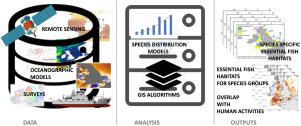
Competition for maritime space generates conflict between human activities and ecosystem conservation; Marine (Spatial) Plans provide conflict resolutions and clarify trade-offs. Spatial plans require appropriate scales, reliable maps of sites important to marine organisms. We present maps of hotspots of Essential Fish Habitats (EFH) at a high spatial resolution for English and Welsh waters. These outputs can be integrated into an improved spatial plan for these waters. We modelled the potential distribution for different life stages of commercially and ecologically important species, as a high-resolution indicator of the distribution of essential fish habitats. Model outputs were combined with observed, low-resolution fish distributions to derive ‘hotspot’ spawning and nursery areas. The Celtic Sea and coastal areas of the North Sea are highlighted as important spawning and nursery grounds. High pressure from human activities is expected to impact EFHs in the English Channel and the central-east Celtic Sea. Our approach maintains the high resolution of the model-derived maps while filling in information gaps. As fish share essential habitat preferences, protected hotspot areas are expected to sustain a multitude of species. Overlaying human activities, such as fishing, on the hotspot maps allows managers to identify areas of conservation interest and apply appropriate measures. The method is directly applicable to other areas and can be extended to use multiple sources of data for model development.
中文翻译:
鱼类栖息地保护热点:以英国和威尔士水域为例
争夺海洋空间会在人类活动和生态系统保护之间产生冲突;海洋(空间)计划提供了解决冲突的方法,并阐明了权衡取舍。空间计划需要适当的比例尺,对海洋生物重要的地点的可靠地图。我们以英语和威尔士水域的高分辨率显示了基本鱼类栖息地(EFH)热点的地图。这些输出可以集成到这些水域的改进空间规划中。我们对商业和生态上重要物种在不同生命阶段的潜在分布进行了建模,以此作为基本鱼类栖息地分布的高分辨率指标。模型输出与观察到的低分辨率鱼类分布相结合,得出“热点”产卵区和育苗区。凯尔特海和北海沿海地区被强调为重要的产卵场和苗圃场。预计人类活动的高压将影响英吉利海峡和中东部凯尔特海的EFH。我们的方法可以在保留信息空白的同时,保持模型衍生地图的高分辨率。由于鱼类享有重要的栖息地偏好,因此受保护的热点地区有望维持多种物种。在热点地图上叠加诸如钓鱼之类的人类活动,管理人员可以识别出保护区,并采取适当的措施。该方法直接适用于其他领域,可以扩展为使用多个数据源进行模型开发。预计人类活动的高压将影响英吉利海峡和中东部凯尔特海的EFH。我们的方法可以在保留信息空白的同时,保持模型衍生地图的高分辨率。由于鱼类享有重要的栖息地偏好,因此受保护的热点地区有望维持多种物种。在热点地图上叠加诸如钓鱼之类的人类活动,管理人员可以识别出保护区,并采取适当的措施。该方法直接适用于其他领域,可以扩展为使用多个数据源进行模型开发。预计人类活动的高压将影响英吉利海峡和中东部凯尔特海的EFH。我们的方法可以在保留信息空白的同时,保持模型衍生地图的高分辨率。由于鱼类享有重要的栖息地偏好,因此受保护的热点地区有望维持多种物种。在热点地图上叠加诸如钓鱼之类的人类活动,管理人员可以识别出保护区,并采取适当的措施。该方法直接适用于其他领域,可以扩展为使用多个数据源进行模型开发。受保护的热点地区有望维持多种物种。在热点地图上叠加诸如钓鱼之类的人类活动,管理人员可以识别出保护区,并采取适当的措施。该方法直接适用于其他领域,可以扩展为使用多个数据源进行模型开发。受保护的热点地区有望维持多种物种。在热点地图上叠加诸如钓鱼之类的人类活动,管理人员可以识别出保护区,并采取适当的措施。该方法直接适用于其他领域,可以扩展为使用多个数据源进行模型开发。


 京公网安备 11010802027423号