Geoscience Frontiers ( IF 8.5 ) Pub Date : 2021-03-16 , DOI: 10.1016/j.gsf.2021.101183 Kalil Traoré , David Menier , Erwan Gensac , Pascal Le Roy , Clément Lambert , Paul Bessin , Kevin Pedoja , Anne Duperret , Romain Le Gall
|
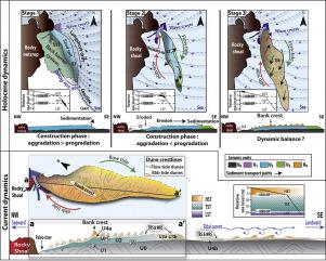
The morphology and internal structure of the Horaine Bank (Bay of Saint-Brieuc, NW France) are described based on multibeam echosounder and high-resolution seismic datasets coupled with vibro-core data. The Horaine Bank shows large-scale bedforms in the lee of a submerged rocky shoal, which allowed defining it as a Banner Bank. The internal structure of the sandbank reveals four seismic units (U1–U4) on a Cambrian basement (U0). The basal unit U1 is interpreted as reworked lowstand fluvial sediments those infilled micro incised valleys during a rise in sea level. This unit is overlain by paleo-coastal barrier sand-spit (U2) whose development was controlled by swell in the context of a rapid rise in sea level. The successive prograding unit (U3) is interpreted as flooding deposits in continuity with unit U2. The unit U4 is characterized by oblique reflectors oriented in two opposite directions. This last unit, dated post 3500 yr BP, corresponds to migrating dunes superimposed on the bank and observable in the high-resolution bathymetric data. The strong correlation between tidal currents and the apparent clockwise migration of dune crests suggests the presence of a tidal gyre controlling the present-day dynamics of most of the Horaine bank dunes. This study proposes a new model for the construction of banner banks characterized by the gradual transition of a sand spit to a banner bank during marine transgression and ensuing hydrodynamic variability.
中文翻译:
受形态动力学和大潮海岸结构设置控制的全新世横幅银行的演变:Saint-Brieuc湾(欧洲西北)
基于多波束回波测深仪和高分辨率地震数据集以及振动芯数据,描述了Horaine Bank(法国西北圣贝里乌克湾)的形态和内部结构。Horaine Bank在淹没的岩石浅滩的后部显示出大型床形,因此可以将其定义为Banner Bank。沙洲的内部结构揭示了寒武纪基底(U0)上的四个地震单元(U1-U4)。基本单位U1被解释为在海平面上升期间填充了微切谷的低水位河流沉积物。这个单元被古海岸屏障沙坑(U2)覆盖,在海平面迅速上升的背景下,沙丘的发展受到膨胀的控制。连续的精制单元(U3)被解释为与单元U2连续的水淹沉积物。单元U4的特征在于在两个相反方向上定向的倾斜反射器。最后一个日期为3500年BP后的单位对应于叠加在河岸上且可在高分辨率测深数据中观察到的沙丘。潮流与沙丘顶峰顺时针方向的迁移之间存在很强的相关性,这表明存在一个潮汐旋流,其控制着大多数Horaine河岸沙丘的当今动态。这项研究提出了一种新的横幅堤岸建设模型,其特征是在海侵过程中沙嘴逐渐过渡到横幅堤岸,从而确保了水动力的可变性。潮流与沙丘顶峰顺时针方向的迁移之间存在很强的相关性,这表明存在一个潮汐旋流,其控制着大多数Horaine河岸沙丘的当今动态。这项研究提出了一种新的横幅堤岸建设模型,其特征是在海侵过程中沙嘴逐渐过渡到横幅堤岸,从而确保了水动力的可变性。潮流与沙丘顶峰顺时针方向的迁移之间存在很强的相关性,这表明存在一个潮汐旋流,其控制着大多数Horaine河岸沙丘的当今动态。这项研究提出了一种新的横幅堤岸建设模型,其特征是在海侵过程中沙嘴逐渐过渡到横幅堤岸,从而确保了水动力的可变性。


 京公网安备 11010802027423号