当前位置:
X-MOL 学术
›
Remote Sens. Ecol. Conserv.
›
论文详情
Our official English website, www.x-mol.net, welcomes your
feedback! (Note: you will need to create a separate account there.)
Remote sensing of wildlife connectivity networks and priority locations for conservation in the Southern Agricultural Growth Corridor (SAGCOT) in Tanzania
Remote Sensing in Ecology and Conservation ( IF 3.9 ) Pub Date : 2021-03-10 , DOI: 10.1002/rse2.199 Pablo Cisneros‐Araujo 1 , Miguel Ramirez‐Lopez 2 , Diego Juffe‐Bignoli 3, 4 , Rasmus Fensholt 5 , Javier Muro 6 , María C. Mateo‐Sánchez 1 , Neil D. Burgess 3, 7
Remote Sensing in Ecology and Conservation ( IF 3.9 ) Pub Date : 2021-03-10 , DOI: 10.1002/rse2.199 Pablo Cisneros‐Araujo 1 , Miguel Ramirez‐Lopez 2 , Diego Juffe‐Bignoli 3, 4 , Rasmus Fensholt 5 , Javier Muro 6 , María C. Mateo‐Sánchez 1 , Neil D. Burgess 3, 7
Affiliation
|
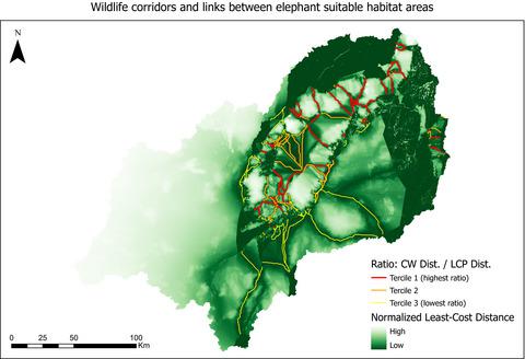
Land conversion is causing habitat loss and fragmentation worldwide, particularly in Africa, where the proliferation of agricultural development corridors may threaten vital areas for ecological connectivity and wildlife survival. To conserve connectivity, careful landscape planning is necessary, which strongly relies on remotely sensed land cover maps. Here, we present a remote sensing-based framework that efficiently identifies priority locations for connectivity conservation. We applied the framework in the Kilombero catchment and development cluster of the Southern Agricultural Growth Corridor (SAGCOT) in Tanzania, where new agricultural development projects could act as barriers for connectivity. Using satellite imagery from Sentinel-1 and 2, we mapped the mixture of mountain and lowland land covers and habitats with an overall accuracy of 75%. Then, we assessed ecological connectivity to predict African elephant corridors and prioritize them in two ways. First, we identified elephant corridors that contribute the most to current landscape connectivity, and second, we identified those whose restoration would significantly enhance landscape functionality and improve the current connectivity level. We mapped 214 potential elephant corridors, identified 43 of them as priority for conservation, and 43 as target for restoration. Our model predicted four already known corridor areas in and around the Kilombero valley floodplain, and other important corridors not yet identified by previous studies in the south of the basin. Priority elephant corridors inside the floodplain showed narrow widths and low permeability, indicating low functionality in the connectivity network. Nevertheless, the abundance of priority corridors for restoration suggests that connectivity could be recovered if the recommended measures are applied during SAGCOT planning and implementation process. Our findings demonstrate the possibilities of combining multispectral and radar data for guiding biodiversity management in development corridors and for assessing ecological connectivity worldwide.
中文翻译:

坦桑尼亚南部农业增长走廊 (SAGCOT) 野生动物连通网络和优先保护地点的遥感
土地转变正在全球范围内造成栖息地丧失和破碎化,特别是在非洲,农业发展走廊的扩散可能威胁到生态连通性和野生动物生存的重要地区。为了保持连通性,需要仔细的景观规划,这在很大程度上依赖于遥感土地覆盖图。在这里,我们提出了一个基于遥感的框架,可以有效地确定连通性保护的优先位置。我们在坦桑尼亚南部农业增长走廊 (SAGCOT) 的 Kilombero 流域和开发集群中应用了该框架,在那里新的农业开发项目可以作为连通性的障碍。使用来自 Sentinel-1 和 2 的卫星图像,我们以 75% 的整体准确度绘制了山地和低地土地覆盖和栖息地的混合图。然后,我们评估了生态连通性以预测非洲大象走廊,并以两种方式对其进行优先排序。首先,我们确定了对当前景观连通性贡献最大的大象走廊,其次,我们确定了那些恢复将显着增强景观功能并提高当前连通性水平的大象走廊。我们绘制了 214 条潜在的大象走廊,将其中 43 条确定为优先保护,43 条确定为恢复目标。我们的模型预测了基隆贝罗河谷洪泛区及其周围的四个已知走廊区域,以及盆地南部先前研究尚未确定的其他重要走廊。泛滥平原内的优先大象走廊宽度较窄,渗透率较低,表明连通性网络的功能较低。尽管如此,大量的优先恢复走廊表明,如果在 SAGCOT 规划和实施过程中采用建议的措施,则可以恢复连通性。我们的研究结果证明了将多光谱和雷达数据相结合以指导发展走廊中的生物多样性管理和评估全球生态连通性的可能性。
更新日期:2021-03-10
中文翻译:
坦桑尼亚南部农业增长走廊 (SAGCOT) 野生动物连通网络和优先保护地点的遥感
土地转变正在全球范围内造成栖息地丧失和破碎化,特别是在非洲,农业发展走廊的扩散可能威胁到生态连通性和野生动物生存的重要地区。为了保持连通性,需要仔细的景观规划,这在很大程度上依赖于遥感土地覆盖图。在这里,我们提出了一个基于遥感的框架,可以有效地确定连通性保护的优先位置。我们在坦桑尼亚南部农业增长走廊 (SAGCOT) 的 Kilombero 流域和开发集群中应用了该框架,在那里新的农业开发项目可以作为连通性的障碍。使用来自 Sentinel-1 和 2 的卫星图像,我们以 75% 的整体准确度绘制了山地和低地土地覆盖和栖息地的混合图。然后,我们评估了生态连通性以预测非洲大象走廊,并以两种方式对其进行优先排序。首先,我们确定了对当前景观连通性贡献最大的大象走廊,其次,我们确定了那些恢复将显着增强景观功能并提高当前连通性水平的大象走廊。我们绘制了 214 条潜在的大象走廊,将其中 43 条确定为优先保护,43 条确定为恢复目标。我们的模型预测了基隆贝罗河谷洪泛区及其周围的四个已知走廊区域,以及盆地南部先前研究尚未确定的其他重要走廊。泛滥平原内的优先大象走廊宽度较窄,渗透率较低,表明连通性网络的功能较低。尽管如此,大量的优先恢复走廊表明,如果在 SAGCOT 规划和实施过程中采用建议的措施,则可以恢复连通性。我们的研究结果证明了将多光谱和雷达数据相结合以指导发展走廊中的生物多样性管理和评估全球生态连通性的可能性。


 京公网安备 11010802027423号