Environmental Modelling & Software ( IF 4.8 ) Pub Date : 2021-03-09 , DOI: 10.1016/j.envsoft.2021.105030 Arash Modaresi Rad , Jason Kreitler , Mojtaba Sadegh
|
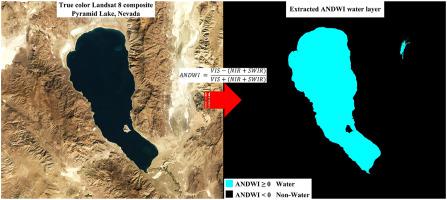
We present a comprehensive critical review of well-established satellite remote sensing water indices and offer a novel, robust Augmented Normalized Difference Water Index (ANDWI). ANDWI employs an expanded set of spectral bands, RGB, NIR, and SWIR1-2, to maximize the contrast between water and non-water pixels. Further, we implement a dynamic thresholding method, the Otsu algorithm, to enhance ANDWI's performance. Applied to a variety of environmental conditions, ANDWI with Otsu-thresholding offered the highest overall accuracy (accuracy = 0.98, F1 = 0.98, and Kappa = 0.96) compared to other indices (NDWI, MNDWI, AWEI, WI). We also propose a novel cloud filtering algorithm that substantially increases the number of useable images compared to the conventional cloud-free composites (124% increased observations in the studied area) and resolves inappropriate masking of water bodies and hot sands as clouds by conventional methods. Finally, we develop a Google Earth Engine App to readily delineate 16-day surface water bodies across the globe.
中文翻译:
增强的归一化差水指数可改善地表水监测
我们对完善的卫星遥感水指数进行全面的批判性审查,并提供新颖,强大的增强型归一化差异水指数(ANDWI)。ANDWI采用了一组扩展的光谱带,RGB,NIR和SWIR 1-2,以最大化水像素和非水像素之间的对比度。此外,我们实现了动态阈值方法,即Otsu算法,以增强ANDWI的性能。与其他指数(NDWI,MNDWI,AWEI,WI)相比,具有Otsu阈值的ANDWI在各种环境条件下均可提供最高的整体精度(精度= 0.98,F1 = 0.98和Kappa = 0.96)。我们还提出了一种新颖的云过滤算法,与传统的无云合成物相比,该算法显着增加了可用图像的数量(在研究区域内观测值增加了124%),并通过常规方法解决了水体和热沙作为云的不适当掩盖。最后,我们开发了一个Google Earth Engine应用程序,可以轻松描绘出全球16天的地表水体。


 京公网安备 11010802027423号