当前位置:
X-MOL 学术
›
Meteorol. Appl.
›
论文详情
Our official English website, www.x-mol.net, welcomes your
feedback! (Note: you will need to create a separate account there.)
High‐resolution flood precipitation and streamflow relationships in two US river basins
Meteorological Applications ( IF 2.3 ) Pub Date : 2021-03-05 , DOI: 10.1002/met.1979 Erin Dougherty 1, 2 , Ryan Morrison 3 , Kristen Rasmussen 1
Meteorological Applications ( IF 2.3 ) Pub Date : 2021-03-05 , DOI: 10.1002/met.1979 Erin Dougherty 1, 2 , Ryan Morrison 3 , Kristen Rasmussen 1
Affiliation
|
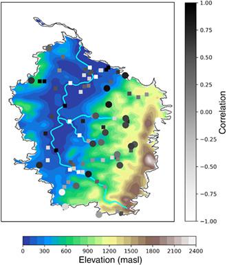
Relationships between rainfall and river discharge are important for governing flood characteristics and predicting flood impacts. Previous studies have examined these relationships, but they lacked the high‐resolution precipitation data necessary to analyse rainfall–streamflow correlations for individual flood episodes. The present study addresses this limitation by examining rainfall–streamflow relationships in two topographically and climatically different river basins: the Wabash River basin in Indiana and the Willamette River basin in Oregon, using high‐resolution, sub‐basin precipitation and discharge data. Results show that flood rainfall–streamflow relationships are highly spatially variable on a sub‐basin scale. In the Wabash basin, strong positive correlations exist between rainfall and streamflow near urban areas and slight terrain gradients during flash floods, while weaker correlations between rainfall and streamflow are observed in other areas of the basin and for slow‐rise floods. In the Willamette basin, strong positive slow‐rise flood rainfall–streamflow relationships occur in referenced gauges in the eastern, mountainous part of the basin, while strong negative correlations occur in non‐referenced gauges near reservoirs along the main rivers. Results suggest that in addition to high‐resolution rainfall variability, the influence of urbanization, topography and water management on flood rainfall–streamflow relationships needs to be considered in order to forecast local flood impacts better.
中文翻译:

美国两个流域的高分辨率洪水降水与流量关系
降雨与河流流量之间的关系对于控制洪水特征和预测洪水影响非常重要。先前的研究已经检查了这些关系,但它们缺乏分析单个洪水发作的降雨与流量相关性所必需的高分辨率降水数据。本研究通过使用高分辨率的次流域降水和流量数据,研究了两个地形和气候不同的流域(印第安纳州的瓦巴什河流域和俄勒冈州的威拉米特河流域)的降雨与流量关系,从而解决了这一局限性。结果表明,在次流域尺度上,洪水的降雨-流量关系在空间上是高度可变的。在沃巴什盆地,暴雨期间城市地区附近的降雨与径流之间存在很强的正相关,而山洪暴发期间地形梯度很小,而在流域其他地区和缓慢上升的洪水中,降雨与径流之间的相关性较弱。在威拉米特盆地,该盆地东部山区的参考水位出现强烈的正缓慢上升洪水-流量关系,而在主要河流水库附近的未参考水位出现强烈的负相关。结果表明,除了高分辨率降雨的可变性之外,还需要考虑城市化,地形和水管理对洪水降雨-流量关系的影响,以便更好地预测当地洪水的影响。在盆地的其他地区和缓慢上升的洪水中,降雨与水流之间的相关性较弱。在威拉米特盆地,该盆地东部山区的参考水位出现强烈的正缓慢上升洪水-流量关系,而在主要河流水库附近的未参考水位出现强烈的负相关。结果表明,除了高分辨率降雨的可变性之外,还需要考虑城市化,地形和水管理对洪水降雨-流量关系的影响,以便更好地预测当地洪水的影响。在盆地的其他地区和缓慢上升的洪水中,降雨与径流之间的相关性较弱。在威拉米特盆地,该盆地东部山区的参考水位出现强烈的正缓慢上升洪水-流量关系,而在主要河流水库附近的未参考水位出现强烈的负相关。结果表明,除了高分辨率降雨的可变性之外,还需要考虑城市化,地形和水管理对洪水降雨-流量关系的影响,以便更好地预测当地洪水的影响。盆地的山区,而在主要河流水库附近的非参考量表中则存在很强的负相关性。结果表明,除了高分辨率降雨的可变性之外,还需要考虑城市化,地形和水管理对洪水降雨-流量关系的影响,以便更好地预测当地洪水的影响。盆地的山区,而在主要河流水库附近的非参考量表中则存在很强的负相关性。结果表明,除了高分辨率降雨的可变性之外,还需要考虑城市化,地形和水管理对洪水降雨-流量关系的影响,以便更好地预测当地洪水的影响。
更新日期:2021-03-07
中文翻译:
美国两个流域的高分辨率洪水降水与流量关系
降雨与河流流量之间的关系对于控制洪水特征和预测洪水影响非常重要。先前的研究已经检查了这些关系,但它们缺乏分析单个洪水发作的降雨与流量相关性所必需的高分辨率降水数据。本研究通过使用高分辨率的次流域降水和流量数据,研究了两个地形和气候不同的流域(印第安纳州的瓦巴什河流域和俄勒冈州的威拉米特河流域)的降雨与流量关系,从而解决了这一局限性。结果表明,在次流域尺度上,洪水的降雨-流量关系在空间上是高度可变的。在沃巴什盆地,暴雨期间城市地区附近的降雨与径流之间存在很强的正相关,而山洪暴发期间地形梯度很小,而在流域其他地区和缓慢上升的洪水中,降雨与径流之间的相关性较弱。在威拉米特盆地,该盆地东部山区的参考水位出现强烈的正缓慢上升洪水-流量关系,而在主要河流水库附近的未参考水位出现强烈的负相关。结果表明,除了高分辨率降雨的可变性之外,还需要考虑城市化,地形和水管理对洪水降雨-流量关系的影响,以便更好地预测当地洪水的影响。在盆地的其他地区和缓慢上升的洪水中,降雨与水流之间的相关性较弱。在威拉米特盆地,该盆地东部山区的参考水位出现强烈的正缓慢上升洪水-流量关系,而在主要河流水库附近的未参考水位出现强烈的负相关。结果表明,除了高分辨率降雨的可变性之外,还需要考虑城市化,地形和水管理对洪水降雨-流量关系的影响,以便更好地预测当地洪水的影响。在盆地的其他地区和缓慢上升的洪水中,降雨与径流之间的相关性较弱。在威拉米特盆地,该盆地东部山区的参考水位出现强烈的正缓慢上升洪水-流量关系,而在主要河流水库附近的未参考水位出现强烈的负相关。结果表明,除了高分辨率降雨的可变性之外,还需要考虑城市化,地形和水管理对洪水降雨-流量关系的影响,以便更好地预测当地洪水的影响。盆地的山区,而在主要河流水库附近的非参考量表中则存在很强的负相关性。结果表明,除了高分辨率降雨的可变性之外,还需要考虑城市化,地形和水管理对洪水降雨-流量关系的影响,以便更好地预测当地洪水的影响。盆地的山区,而在主要河流水库附近的非参考量表中则存在很强的负相关性。结果表明,除了高分辨率降雨的可变性之外,还需要考虑城市化,地形和水管理对洪水降雨-流量关系的影响,以便更好地预测当地洪水的影响。


 京公网安备 11010802027423号