International Journal of Applied Earth Observation and Geoinformation ( IF 7.6 ) Pub Date : 2021-03-02 , DOI: 10.1016/j.jag.2021.102314 Christian Kempf , Jiaojiao Tian , Franz Kurz , Pablo D’Angelo , Thomas Schneider , Peter Reinartz
|
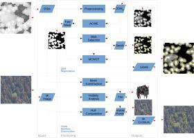
Individual tree crown (ITC) segmentation supports numerous applications in forest management and ecology. In the latter context, special attention is dedicated to the study of angular reflection effects, caused by the interaction of incident sunlight with a canopy. High precision airborne analysis of these effects requires multi-view sensor systems and multi-view ITC segmentation. In particular oblique view image segmentation is difficult and has been addressed by numerous template based methods. This contribution identifies persistent shortcomings in the state of the art and tackles the problem by a multi-step workflow utilizing the digital surface model (DSM), derived from multi-view stereo data. A slightly revised version of the previously published levelset-watershed segmentation of the DSM is presented as the first step. In the second step, the contour of the visible part of a candidate tree in images with known orientation is obtained by means of ray casting and concave hull calculation. The method was tested on a deciduous, mixed and coniferous plot, whose aerial images were acquired using the 3K camera system in 2018 at Kranzberg Forest, Bavaria, Germany. Accuracies were assessed at hand of human operator generated groundtruth tree tops for the DSM as well as images with zenit angles of approximately and 52 degrees. The resulting -scores, averaged over the plots, are /// for the DSM/near-nadir-/oblique-/maximum-oblique-images, respectively.
中文翻译:
斜查看单个树冠的轮廓
单个树冠(ITC)分割支持森林管理和生态学中的许多应用。在后一种情况下,应特别注意研究入射阳光与树冠的相互作用所引起的角反射效应。对这些影响的高精度机载分析需要多视图传感器系统和多视图ITC分割。特别地,斜视图图像分割是困难的,并且已经通过许多基于模板的方法来解决。该贡献指出了现有技术中的持续缺陷,并通过利用从多视图立体数据得出的数字表面模型(DSM)的多步骤工作流解决了该问题。第一步是对先前发布的DSM的水平集-分水岭分割方法进行略微修订。第二步 通过射线投射和凹壳计算获得候选树在具有已知方向的图像中的可见部分的轮廓。该方法在落叶,混合和针叶林地块上进行了测试,该地块的航拍图像于2018年在德国巴伐利亚州的Kranzberg森林中使用3K相机系统获取。评估了人工操作员为DSM生成的地面真木树树顶以及zenit角大约为1的图像的准确性和52度。所结果的-地块的平均得分是 /// 分别用于DSM /近天底/斜/最大斜图像。


 京公网安备 11010802027423号