Science of the Total Environment ( IF 8.2 ) Pub Date : 2021-02-25 , DOI: 10.1016/j.scitotenv.2021.146041 Hyojin Kim , Peter B.E. Sandersen , Rasmus Jakobsen , Anders Juhl Kallesøe , Niels Claes , Gitte Blicher-Mathiesen , Nikolaj Foged , Jens Aamand , Birgitte Hansen
|
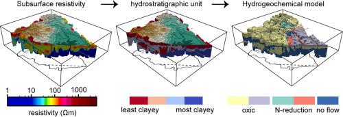
Diffuse pollution of nitrate from agricultural fields is a critical environmental problem around the world. Sources and sinks of nitrate are heterogeneously distributed over various spatial scales, and the connectivity and transport pathways between them also change at different temporal scales. Therefore, understanding the impact of these variabilities in nitrate transport to the aquatic environment is fundamental for a correct numerical modelling of nitrate transport within a catchment. This study, hence, investigated controls on the spatiotemporal variability of nitrate in a glacial landscape and upscaled it to catchment scale by synthesizing geological, hydrogeochemical, and geophysical information. We found that different parts of the sedimentary succession define the locations of nitrate sinks in this catchment. Denitrification mainly may occur mainly around the small patches of postglacial sediments on the outwash plain, which is the youngest formation covering the top layer of the catchment. In contrast, in older geological elements, which constitute the hill and the layers below the outwash plain, oxic, nitrate-containing groundwater was found, probably because of depletion of reduced compounds over the long exposure time. We also found that the boundary between these two formations may govern the seasonal shift of this oxic groundwater's connectivity to the stream consequently nitrate export from the catchment. This conceptual understanding of nitrate transport and sinks then was transformed into a 3D hydrogeochemistry model based on a high-resolution resistivity model of the catchment. We propose that such basic understanding of how a catchment hydrogeochemically operates should be the first step toward setting up a catchment scale hydrological model with reactive N transport.
中文翻译:
冰川沉积流域硝酸盐迁移和归宿的3D水文地球化学模型:迈向数值模型的第一步
来自农田的硝酸盐的扩散污染是世界范围内的关键环境问题。硝酸盐的源和汇在不同的空间尺度上是不均匀分布的,它们之间的连通性和运输途径也在不同的时间尺度上发生变化。因此,了解这些变化对硝酸盐向水环境的迁移的影响,是对流域内硝酸盐迁移进行正确数值模拟的基础。因此,本研究调查了冰川景观中硝酸盐时空变化的控制因素,并通过综合地质,水文地球化学和地球物理信息将其放大到集水规模。我们发现沉积演替的不同部分定义了该流域硝酸盐汇的位置。反硝化作用主要发生在外露平原的冰川后沉积物的小块周围,后者是覆盖流域顶层的最年轻的地层。相反,在较老的地质元素中,它们构成了丘陵和外露平原以下的层,发现了含氧,含硝酸盐的地下水,这可能是由于长时间暴露后化合物的减少所致。我们还发现,这两个地层之间的边界可能控制了该含氧地下水与河流之间的连通性的季节性变化,从而导致流域的硝酸盐输出。然后,将对硝酸盐迁移和汇的这种概念性理解转换为基于流域高分辨率电阻率模型的3D水文地球化学模型。


 京公网安备 11010802027423号