当前位置:
X-MOL 学术
›
Austral Ecol.
›
论文详情
Our official English website, www.x-mol.net, welcomes your
feedback! (Note: you will need to create a separate account there.)
Rephotography, permanent plots and remote sensing data provide varying insights on vegetation change on subantarctic Macquarie Island, 1980–2015
Austral Ecology ( IF 1.6 ) Pub Date : 2021-02-23 , DOI: 10.1111/aec.13015 Nicholas B. Fitzgerald 1 , Jamie B. Kirkpatrick 1 , Jenny J. Scott 1
Austral Ecology ( IF 1.6 ) Pub Date : 2021-02-23 , DOI: 10.1111/aec.13015 Nicholas B. Fitzgerald 1 , Jamie B. Kirkpatrick 1 , Jenny J. Scott 1
Affiliation
|
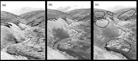
Despite its remoteness, the vegetation of Subantarctic Macquarie Island is amongst the most thoroughly surveyed and monitored in Australia. Eradication of invasive European rabbits was achieved in 2011, after a decline in introduced rabbit populations in the eighties and nineties and a resurgence in the early twenty-first century. The impacts of introduced rabbits and climate change on the vegetation of Macquarie Island are well-documented from long-term plots situated in some, but not all, of the vegetation types. Satellite data are sporadic, with substantial could-free coverage rare. The island has been well-photographed over many years, and several series of long-term photo-monitoring sites have been established over the past few decades. We compared insights on vegetation change derived from repeat landscape photography three years after myxoma virus was established, rabbit population resurgence and rabbits eradication, with plant species cover data from a set of long-term monitoring sites, and with spectral vegetation indices derived from satellite imagery covering the transition from high rabbit numbers to no rabbits. The repeat photography confirmed many well-documented vegetation trends, as well as providing an indication of previously unreported trends: stability of Acaena herbfield despite reduced disturbance; increase in cover of Pleurophyllum hookeri; increase in short grassland vegetation; and constancy in cover of Azorella macquariensis. Although subject to errors related to differences in sample size and resolution, the rephotography data gave the best information on spatial and temporal patterns of overall vegetation change. The plot data, where comparable, were not fully consistent with the rephotography data and are expensive to collect, requiring scientific expertise in the field and much time, while the sporadically available remote sensing data were effective in monitoring the revegetation/devegetation of ground and the recovery of Poa foliosa but we were unable to detect other changes.
中文翻译:

重新摄影、永久地块和遥感数据提供了对亚南极麦格理岛植被变化的不同见解,1980-2015
尽管地处偏远,亚南极麦格理岛的植被是澳大利亚调查和监测最彻底的地区之一。在八十年代和九十年代引入的兔子数量下降并在 21 世纪早期复苏之后,2011 年消灭了入侵的欧洲兔子。引入的兔子和气候变化对麦格理岛植被的影响从位于某些(但不是全部)植被类型的长期样地中得到了充分证明。卫星数据是零星的,大量免费覆盖的情况很少见。该岛多年来一直被很好地拍摄,并且在过去的几十年中建立了几个系列的长期照片监测点。我们比较了粘液瘤病毒建立三年后重复景观摄影得出的植被变化洞察、兔子种群的复苏和兔子的根除,以及来自一组长期监测站点的植物物种覆盖数据,以及来自卫星图像的光谱植被指数涵盖从高兔子数量到没有兔子的过渡。重复拍摄证实了许多有据可查的植被趋势,并提供了以前未报告的趋势的迹象:Acaena herbfield 尽管干扰减少;Pleurophyllum hookeri 的覆盖率增加;矮草地植被增加;Azorella macquariensis 的覆盖范围和稳定性。尽管受与样本大小和分辨率差异相关的误差的影响,重新摄影数据提供了关于整体植被变化的空间和时间模式的最佳信息。可比较的样地数据与重新摄影数据不完全一致,收集费用昂贵,需要实地的科学专业知识和大量时间,而零星可用的遥感数据可有效监测地面的重新植被/植被退化和早熟禾的恢复,但我们无法检测到其他变化。
更新日期:2021-02-23
中文翻译:
重新摄影、永久地块和遥感数据提供了对亚南极麦格理岛植被变化的不同见解,1980-2015
尽管地处偏远,亚南极麦格理岛的植被是澳大利亚调查和监测最彻底的地区之一。在八十年代和九十年代引入的兔子数量下降并在 21 世纪早期复苏之后,2011 年消灭了入侵的欧洲兔子。引入的兔子和气候变化对麦格理岛植被的影响从位于某些(但不是全部)植被类型的长期样地中得到了充分证明。卫星数据是零星的,大量免费覆盖的情况很少见。该岛多年来一直被很好地拍摄,并且在过去的几十年中建立了几个系列的长期照片监测点。我们比较了粘液瘤病毒建立三年后重复景观摄影得出的植被变化洞察、兔子种群的复苏和兔子的根除,以及来自一组长期监测站点的植物物种覆盖数据,以及来自卫星图像的光谱植被指数涵盖从高兔子数量到没有兔子的过渡。重复拍摄证实了许多有据可查的植被趋势,并提供了以前未报告的趋势的迹象:Acaena herbfield 尽管干扰减少;Pleurophyllum hookeri 的覆盖率增加;矮草地植被增加;Azorella macquariensis 的覆盖范围和稳定性。尽管受与样本大小和分辨率差异相关的误差的影响,重新摄影数据提供了关于整体植被变化的空间和时间模式的最佳信息。可比较的样地数据与重新摄影数据不完全一致,收集费用昂贵,需要实地的科学专业知识和大量时间,而零星可用的遥感数据可有效监测地面的重新植被/植被退化和早熟禾的恢复,但我们无法检测到其他变化。


 京公网安备 11010802027423号