Journal of South American Earth Sciences ( IF 1.7 ) Pub Date : 2021-02-23 , DOI: 10.1016/j.jsames.2021.103243 Bonansea Matias , Raquel Bazán , Alba Germán , Anabella Ferral , Giuliana Beltramone , Ana Cossavella , Lucio Pinotti
|
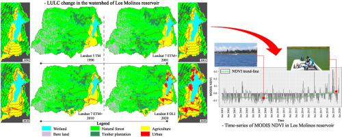
Understanding and modelling land use and land cover (LULC) change have become one of the major subjects of interest for environmental management due to the negative effects that human activities generate on the normal functioning and dynamics of freshwater resources. Remote sensing and geographic information systems (GIS) are essential tools for assessing the drivers that cause LULC change and its relationship with lake and reservoir water quality. The objective of this study was to assess the spatial and temporal dynamics of LULC change in the watershed of Los Molinos reservoir (Argentina), and to investigate its relationship with the reservoir's water quality. Four Landsat imagery was used to analyse the LULC change in the studied watershed and in different buffer zones from 1990 to 2020. Further, the Normalized Difference Vegetation Index (NDVI) derived from a MODIS time-series dataset (2001–2020) was used to explain the effects of LULC change on the status of the reservoir. Results showed that the most significant LULC change started two decades ago and it has intensified during the last ten years. This change is related to the intensification of agriculture activities, and to the increasing conversion into urban areas, mainly on the shores of Los Molinos reservoir. During the period 2010–2020, urbanization located in the 1 km buffer zone defined from the shore of the reservoir increased at an annual rate of 18.02%. The degradation trend of LULC in Los Molinos watershed significantly contributed to the degradation of water quality of the reservoir. This was corroborated by analysing the MODIS NDVI time-series, which showed that since 2014 the NDVI trend-line presented an increasing behaviour and extreme values of NDVI, related to algal blooms, were more frequently observed.
中文翻译:
评估洛斯莫利诺斯水库集水区的土地利用和土地覆被变化及其对水库水质的影响
由于人类活动对淡水资源的正常功能和动态产生负面影响,因此对土地利用和土地覆被(LULC)变化的理解和建模已成为环境管理关注的主要主题之一。遥感和地理信息系统(GIS)是评估导致LULC变化及其与湖泊和水库水质关系的驱动因素的重要工具。这项研究的目的是评估Los Molinos水库(阿根廷)流域内LULC变化的时空动态,并研究其与水库水质的关系。使用四张Landsat影像分析了1990年至2020年所研究的流域和不同缓冲区的LULC变化。此外,来自MODIS时间序列数据集(2001-2020年)的归一化植被指数(NDVI)用于解释LULC变化对储层状态的影响。结果表明,最重大的LULC变化始于二十年前,并且在最近十年中加剧了。这种变化与农业活动的集约化以及与主要在洛斯莫利诺斯水库沿岸的向城市地区的转变有关。在2010-2020年期间,位于水库岸边1公里缓冲区内的城市化以每年18.02%的速度增长。洛斯莫利诺斯河流域的LULC退化趋势显着促进了水库水质的退化。通过分析MODIS NDVI时间序列可以证实这一点,


 京公网安备 11010802027423号