Journal of Hydrology ( IF 5.9 ) Pub Date : 2021-02-23 , DOI: 10.1016/j.jhydrol.2021.126115 Kazem Nosrati , Zeinab Mohammadi-Raigani , Arman Haddadchi , Adrian L. Collins
|
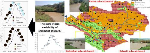
There is an increasing need for reliable information on the origin of fine-grained sediment transported by river systems, but critically, at temporal scales that reflect the timing and pattern of sediment mobilization and delivery in response to effective precipitation events. Temporal variability is likely to be more pronounced in steep mountainous catchments. Accordingly, the main objective of this study was to investigate the temporal variability of sediment sources during and between flood events, in a mountainous catchment in Iran, using a geochemical fingerprinting approach and Bayesian un-mixing model. Potential sediment sources were classified as either tributary sub-basin spatial end members or individual source types represented by surface soils and channel banks. A total of 34 geochemical elements, elemental ratios and weathering indices were measured as potential tracers on a total of 155 samples, including 40 target samples collected across the hydrographs of four flood events at the overall catchment outlet. Virtual mixture tests, used to compare the computed source estimates with known source mixtures, revealed better fits in the case of spatial, rather than source type apportionment. The Bayesian un-mixing model results revealed pronounced intra-storm variations in the relative contributions from both the spatial sources and source types, but with Quaternary surface soils and channel banks being dominant at different stages of the hydrographs. For all the suspended sediment samples collected throughout the three small to medium size events, the Babazid, middle upstream sub-catchment, was the major (84%–99%) sediment source while for the largest sampled event, suspended sediment samples predominantly (>98%) originated from the Kalkoshan, the most southern sub-catchment. By investigating both spatial sources and source types, temporal variations in the dominant sources were revealed. Quaternary geology and channel banks were identified as the main sediment sources. By combining instantaneous suspended sediment loads through the sampled flood events (across all floods) and using the corresponding source proportions derived from the MixSIR un-mixing model, channel banks and channel bank and surface soils generated 2911 kg and 34,171 kg of suspended sediment, respectively. Whilst the use of spatial source end members is practical in medium-size drainage basins, integration with estimates of sediment source type contributions is more informative to managers in selecting relevant sediment mitigation methods. The intra-storm results underscore the need to manage sediment loss from both surface soils and channel banks.
中文翻译:
使用贝叶斯指纹分析方法阐明悬浮物来源的暴风雨内变化
越来越需要关于河流系统细颗粒沉积物来源的可靠信息,但至关重要的是,在时间尺度上反映对有效降水事件响应的沉积物动员和输送的时间和方式。在陡峭的山区流域,时间变化可能更加明显。因此,本研究的主要目的是使用地球化学指纹图谱方法和贝叶斯分解模型研究伊朗山区流域洪水事件期间和洪水事件之间的泥沙源随时间变化。潜在的沉积物来源分为支流子盆地的空间末端成员或以表层土壤和河道堤岸为代表的单个来源类型。共有34种地球化学元素,元素比和风化指数在总共155个样品上作为潜在示踪剂进行了测量,其中包括在整个集水区出口处的4次洪水事件的水位图中收集的40个目标样品。虚拟混合物测试用于将计算出的源估计值与已知源混合物进行比较,显示出在空间分配而非源类型分配的情况下更好的拟合度。贝叶斯非混合模型的结果显示,风暴源内空间源和源类型的相对贡献都有明显的变化,但第四纪表层土壤和河床在水文测量的不同阶段占主导地位。对于在三个中小型活动(巴巴济德,上游上游子汇水区)中收集的所有悬浮沉积物样本,是主要的沉积物来源(84%–99%),而对于最大的采样事件,悬浮的沉积物样品主要(> 98%)来自最南端的子流域卡尔科山。通过调查空间源和源类型,揭示了主要源的时间变化。第四纪地质和河床岸被确定为主要的沉积物来源。通过组合采样洪水事件(所有洪水)中的瞬时悬浮泥沙负荷,并使用根据MixSIR解混模型得出的相应源比例,河床岸,河岸岸和表层土壤分别产生2911 kg和34171 kg的悬浮泥沙。 。尽管在中型流域中使用空间源端部件是可行的,与沉积物来源类型贡献的估算值相结合,对于管理者选择相关的沉积物缓解方法更具参考价值。暴风雨中的结果突显了需要管理地表土壤和河道两岸的沉积物流失。


 京公网安备 11010802027423号