Earth-Science Reviews ( IF 10.8 ) Pub Date : 2021-02-22 , DOI: 10.1016/j.earscirev.2021.103564 Jonathan C. Evenick
|
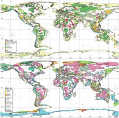
Sedimentary basins have been well documented for many years, but their boundaries are often inadequately represented. This study delineated 764 basins using global geologic datasets to create more consistent basin outlines that can be utilized to conduct future global studies. Every sedimentary basin contains an incomplete record of Earth's history, but the study of all of the global basins provides a more complete view of the evolution of the planet as well as a better framework to study the resources within these basins. Additional basin attributes were captured that will aid future research and modeling (name, type, age, area, depth, presence of evaporites, evaporite type, presence of volcanics, etc.).
Most sedimentary basins formed during the breakup of Rodinia, Pannotia, and Pangea (Proterozoic-Cambrian and Mesozoic). Many of the older basins are now situated in the interiors of continents as intracratonic and foreland basins, whereas most of the younger basins are located at the edges of the continents as passive margins, strike-slip, or arc-related basins. The basin type also was found to relate to the maximum sediment thickness with passive margin, foreland, fold and thrust belt, and intracratonic basins often having the thickest sedimentary sequences (>3.0–4.0 km). It was also found that 217 basins contained 369 evaporite intervals and that these sequences were most often located within passive margins and foreland basins, and almost never observed in backarc - marginal sea and forearc basins. Temporally, evaporite deposition was somewhat intermittent throughout Earth's history, but there was widespread deposition during the late Permian and late Triassic intervals with other notable events during the Neoproterozoic-early Cambrian, Aptian-Albian, middle Eocene, and late Miocene (Messinian) time periods. Based on paleogeographic reconstructions, almost all of the 369 evaporite units were deposited within 45 degrees of the equator and were likely influenced by confluence of regional and global factors (e.g., tectonic events, geographical restrictions, and climate).
中文翻译:
使用修订后的全球沉积盆地图了解地球的历史
多年以来,沉积盆地已经有大量文献记载,但是它们的边界常常显示得不够充分。这项研究使用全球地质数据描绘了764个盆地,以创建更一致的盆地轮廓,可用于进行未来的全球研究。每个沉积盆地都包含不完整的地球历史记录,但是对所有全球盆地的研究提供了关于行星演化的更完整视图,以及一个研究这些盆地中资源的更好框架。捕获了其他盆地属性,这将有助于将来的研究和建模(名称,类型,年龄,面积,深度,蒸发岩的存在,蒸发岩的类型,火山的存在等)。
大多数沉积盆地形成于Rodinia,Pantonia和Pangea(元古代—寒武纪和中生代)破裂期间。现在,许多较早的盆地都位于大陆内部,如克拉通内陆和前陆盆地,而大多数较年轻的盆地都位于大陆的边缘,如被动边缘,走滑或与弧有关的盆地。还发现盆地类型与最大沉积物厚度有关,具有被动边缘,前陆,褶皱和逆冲带,以及克拉通盆地通常具有最厚的沉积层序(> 3.0-4.0 km)。还发现有217个盆地包含369个蒸发岩层段,并且这些序列最常位于被动边缘和前陆盆地内,而在后弧-边缘海和前陆盆地中几乎从未观察到。暂时 蒸发岩沉积在整个地球历史上都是断断续续的,但是在二叠纪晚期和三叠纪晚期存在广泛的沉积,同时在新元古代-寒武纪早期,阿普天一阿尔比亚,中始新世和中新世(Messinian)时期也有其他值得注意的事件。根据古地理重建,几乎所有369个蒸发岩单元都沉积在赤道45度以内,并可能受区域和全球因素(例如构造事件,地理限制和气候)的汇合影响。


 京公网安备 11010802027423号